Property Record
256 W Morris Dr, Queen Valley, AZ 85118


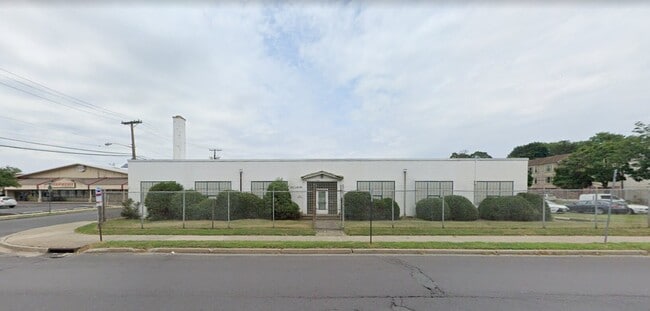
This Property Is For Sale
Current Lease Availabilities
NEARBY LISTINGS FOR SALE OR LEASE
Property Detail
256 W Morris Dr
11-18201-0000-00001
Mercer
Industrialgeneral
New Jersey
X
1
34021C0209F
1.44 AC
2024
Trenton/295
2025
Northern New Jersey
000400
Trenton-Princeton, NJ
27,363 SF
DEMOGRAPHICS near 256 W Morris Dr
1 Mile
3 Mile
5 Mile
2024 Total Population
32,677
130,831
252,606
2029 Population
31,985
129,139
250,097
Pop Growth 2024-2029
(2.12%)
(1.29%)
(0.99%)
Average Age
34
37
40
2024 Total Households
9,633
46,037
93,079
HH Growth 2024-2029
(2.22%)
(1.26%)
(1.03%)
Median Household Inc
$51,863
$57,173
$71,696
Avg Household Size
3.10
2.70
2.60
2024 Avg HH Vehicles
1.00
1.00
2.00
Median Home Value
$103,559
$157,740
$244,457
Median Year Built
1947
1949
1955
Nearby Places
Map Layers
Map Styles
 Street
 Aerial
- Restaurants
- Banks
- Shops
- Fitness
- Groceries
PUBLIC TRANSPORTATION
TRANSIT/SUBWAY
Cass Street (River LINE - River LINE (River LINE))
DRIVE
WALK
Distance
Cass Street (River LINE - River LINE (River LINE))
1 min
11 min
0.6 mi
Hamilton Avenue (River LINE - River LINE (River LINE))
DRIVE
WALK
Distance
Hamilton Avenue (River LINE - River LINE (River LINE))
3 min
20 min
1.1 mi
COMMUTER RAIL
Trenton Transit Center (Trenton Line - SEPTA)
DRIVE
WALK
Distance
Trenton Transit Center (Trenton Line - SEPTA)
3 min
1.6 mi
Trenton Transit Center (Njt) (Northeast Corridor Line - NJ Transit Commuter Rail (NJ Transit), R7 - NJ Transit Commuter Rail (NJ Transit), River LINE - NJ Transit Commuter Rail (NJ Transit))
DRIVE
WALK
Distance
Trenton Transit Center (Njt) (Northeast Corridor Line - NJ Transit Commuter Rail (NJ Transit), R7 - NJ Transit Commuter Rail (NJ Transit), River LINE - NJ Transit Commuter Rail (NJ Transit))
6 min
2.2 mi
AIRPORT
Trenton Mercer
DRIVE
WALK
Distance
Trenton Mercer
14 min
7.5 mi
Freight Ports
Port of Philadelphia
DRIVE
WALK
Distance
Port of Philadelphia
44 min
29.9 mi
Nearby Properties
Address
Land Use
TOTAL SIZE
Lot Size
Zoning
Address
Land Use
TOTAL SIZE
Lot Size
Zoning
8.23 AC
BA
Address
Land Use
TOTAL SIZE
Lot Size
Zoning
26 AC
HIST
Address
Land Use
TOTAL SIZE
Lot Size
Zoning
6.69 AC
BA
Address
Land Use
TOTAL SIZE
Lot Size
Zoning
13.73 AC
Address
Land Use
TOTAL SIZE
Lot Size
Zoning
Address
Land Use
TOTAL SIZE
Lot Size
Zoning
879,376 SF
2.54 AC
BA
Address
Land Use
TOTAL SIZE
Lot Size
Zoning
43,715 SF
49.95 AC
Address
Land Use
TOTAL SIZE
Lot Size
Zoning
125,000 SF
3.68 AC
MU
Address
Land Use
TOTAL SIZE
Lot Size
Zoning
104,448 SF
8.49 AC
IA
Address
Land Use
TOTAL SIZE
Lot Size
Zoning
5.38 AC
MU
Address
Land Use
TOTAL SIZE
Lot Size
Zoning
288,000 SF
1.23 AC
BA
Address
Land Use
TOTAL SIZE
Lot Size
Zoning
35.83 AC
RB
Address
Land Use
TOTAL SIZE
Lot Size
Zoning
0.24 AC
BA
Address
Land Use
TOTAL SIZE
Lot Size
Zoning
186,960 SF
2.37 AC
BA
Address
Land Use
TOTAL SIZE
Lot Size
Zoning
212,074 SF
0.82 AC
BA
Address
Land Use
TOTAL SIZE
Lot Size
Zoning
13.85 AC
MU
Address
Land Use
TOTAL SIZE
Lot Size
Zoning
323,087 SF
1.95 AC
PM
Address
Land Use
TOTAL SIZE
Lot Size
Zoning
161,080 SF
2.21 AC
BA
Address
Land Use
TOTAL SIZE
Lot Size
Zoning
10.29 AC
RB
Address
Land Use
TOTAL SIZE
Lot Size
Zoning
41,000 SF
0.91 AC
HIST
Address
Land Use
TOTAL SIZE
Lot Size
Zoning
158,000 SF
2.06 AC
BA
Address
Land Use
TOTAL SIZE
Lot Size
Zoning
4.07 AC
MU
Address
Land Use
TOTAL SIZE
Lot Size
Zoning
357 SF
0.96 AC
HIST
Address
Land Use
TOTAL SIZE
Lot Size
Zoning
260,160 SF
0.84 AC
BA
Address
Land Use
TOTAL SIZE
Lot Size
Zoning
161,520 SF
0.77 AC
BA
Address
Land Use
TOTAL SIZE
Lot Size
Zoning
23.53 AC
AT
Address
Land Use
TOTAL SIZE
Lot Size
Zoning
112,840 SF
Address
Land Use
TOTAL SIZE
Lot Size
Zoning
2.60 AC
BA
Address
Land Use
TOTAL SIZE
Lot Size
Zoning
108,275 SF
0.90 AC
BA
Address
Land Use
TOTAL SIZE
Lot Size
Zoning
82,244 SF
5.35 AC
IA
The World's #1 Commercial Real Estate Marketplace
Connect with us
© 2026 CoStar Group
The information above has been obtained from sources believed reliable. While we do not doubt its accuracy we have not verified it and make no guarantee, warranty or representation about it. It is your responsibility to independently confirm its accuracy and completeness. Any projections, opinions, assumptions, or estimates used are for example only and do not represent the current or future performance of the property. The value of this transaction to you depends on tax and other factors which should be evaluated by your tax, financial, and legal advisors. You and your advisors should conduct a careful, independent investigation of the property to determine to your satisfaction the suitability of the property for your needs.