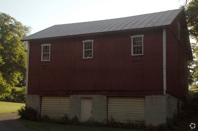
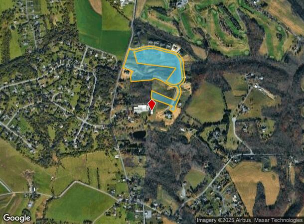
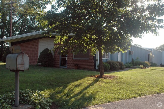
Property Record
256 N Hoernerstown Rd, Hummelstown, PA 17036

NEARBY LISTINGS FOR SALE OR LEASE
-
-
View all Hummelstown listings for sale on LoopNet.com
Property Detail
256 N Hoernerstown Rd
56-005-007
Farm Crest Phase I
Residentialacreage
Dauphin
X
Pennsylvania
42043C0361D
11.42 AC
2025
Harrisburg Area East
2025
Philadelphia
024503
Harrisburg-Carlisle, PA
2,205 SF
DEMOGRAPHICS near 256 N Hoernerstown Rd
1 Mile
3 Mile
5 Mile
2024 Total Population
907
33,654
98,527
2029 Population
922
34,311
100,347
Pop Growth 2024-2029
+ 1.65%
+ 1.95%
+ 1.85%
Average Age
45
41
41
2024 Total Households
349
13,675
39,705
HH Growth 2024-2029
+ 1.72%
+ 2.11%
+ 1.96%
Median Household Inc
$97,321
$91,422
$82,103
Avg Household Size
2.60
2.40
2.40
2024 Avg HH Vehicles
3.00
2.00
2.00
Median Home Value
$309,901
$260,436
$248,210
Median Year Built
1975
1990
1979
Nearby Places
Map Layers
Map Styles
 Street
 Aerial
- Restaurants
- Banks
- Shops
- Fitness
- Groceries
PUBLIC TRANSPORTATION
COMMUTER RAIL
Middletown (Keystone Service - Amtrak)
DRIVE
WALK
Distance
Middletown (Keystone Service - Amtrak)
19 min
8.5 mi
AIRPORT
Harrisburg International
DRIVE
WALK
Distance
Harrisburg International
21 min
10.7 mi
Freight Ports
Port of Baltimore
DRIVE
WALK
Distance
Port of Baltimore
124 min
90.2 mi
Nearby Properties
Address
Land Use
TOTAL SIZE
Lot Size
Zoning
Address
Land Use
TOTAL SIZE
Lot Size
Zoning
2,106 SF
458.45 AC
Address
Land Use
TOTAL SIZE
Lot Size
Zoning
57,016 SF
43.70 AC
Address
Land Use
TOTAL SIZE
Lot Size
Zoning
4,176 SF
192.96 AC
Address
Land Use
TOTAL SIZE
Lot Size
Zoning
188,919 SF
193.39 AC
Address
Land Use
TOTAL SIZE
Lot Size
Zoning
3,135 SF
51.95 AC
Address
Land Use
TOTAL SIZE
Lot Size
Zoning
211,430 SF
38.50 AC
Address
Land Use
TOTAL SIZE
Lot Size
Zoning
239,046 SF
23 AC
Address
Land Use
TOTAL SIZE
Lot Size
Zoning
95,192 SF
52.43 AC
Address
Land Use
TOTAL SIZE
Lot Size
Zoning
9,300 SF
15.81 AC
Address
Land Use
TOTAL SIZE
Lot Size
Zoning
77,280 SF
9.60 AC
Address
Land Use
TOTAL SIZE
Lot Size
Zoning
196,000 SF
12.42 AC
Address
Land Use
TOTAL SIZE
Lot Size
Zoning
7,264 SF
13.84 AC
Address
Land Use
TOTAL SIZE
Lot Size
Zoning
67,968 SF
13.34 AC
Address
Land Use
TOTAL SIZE
Lot Size
Zoning
105,650 SF
8.44 AC
Address
Land Use
TOTAL SIZE
Lot Size
Zoning
79,302 SF
19.64 AC
Address
Land Use
TOTAL SIZE
Lot Size
Zoning
27,248 SF
36.48 AC
Address
Land Use
TOTAL SIZE
Lot Size
Zoning
64,878 SF
14.59 AC
Address
Land Use
TOTAL SIZE
Lot Size
Zoning
8,780 SF
22.85 AC
Address
Land Use
TOTAL SIZE
Lot Size
Zoning
7,643 SF
14 AC
Address
Land Use
TOTAL SIZE
Lot Size
Zoning
17,275 SF
27.89 AC
Address
Land Use
TOTAL SIZE
Lot Size
Zoning
7,316 SF
17.61 AC
Address
Land Use
TOTAL SIZE
Lot Size
Zoning
40,712 SF
17.80 AC
Address
Land Use
TOTAL SIZE
Lot Size
Zoning
49.11 AC
Address
Land Use
TOTAL SIZE
Lot Size
Zoning
100,902 SF
6.02 AC
Address
Land Use
TOTAL SIZE
Lot Size
Zoning
2,085 SF
14.01 AC
Address
Land Use
TOTAL SIZE
Lot Size
Zoning
24,553 SF
2.77 AC
Address
Land Use
TOTAL SIZE
Lot Size
Zoning
14,884 SF
9.96 AC
Address
Land Use
TOTAL SIZE
Lot Size
Zoning
50,786 SF
4.37 AC
Address
Land Use
TOTAL SIZE
Lot Size
Zoning
100,000 SF
10.80 AC
Address
Land Use
TOTAL SIZE
Lot Size
Zoning
13,272 SF
11.17 AC
The World's #1 Commercial Real Estate Marketplace
Connect with us
© 2025 CoStar Group
The information above has been obtained from sources believed reliable. While we do not doubt its accuracy we have not verified it and make no guarantee, warranty or representation about it. It is your responsibility to independently confirm its accuracy and completeness. Any projections, opinions, assumptions, or estimates used are for example only and do not represent the current or future performance of the property. The value of this transaction to you depends on tax and other factors which should be evaluated by your tax, financial, and legal advisors. You and your advisors should conduct a careful, independent investigation of the property to determine to your satisfaction the suitability of the property for your needs.