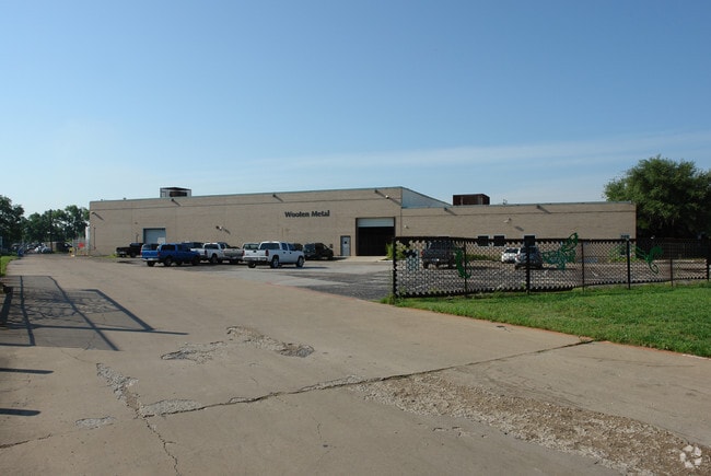
Property Record
256 Regal Row, Dallas, TX 75247


Property Detail
256 Regal Row
00000779470000000
BROOK HOLLOW INDUSTRIAL DIST 7 BLK 72/7940 & ABND DART SPUR ACS 9.2429 VOL2005139/4729 DD07142005 CO-DC 7940 072 00000 2007940 072
Warehouse
DALLAS
Z116
Texas
2025
9.24 AC
2025
West Brookhollow
010003
Dallas/Ft Worth
78,772 SF
Dallas-Fort Worth-Arlington, TX
NEARBY LISTINGS FOR SALE OR LEASE
DEMOGRAPHICS near 256 Regal Row
1 mile
3 mile
5 mile
2025 Total Population
276
58,057
258,831
2030 Population
281
59,853
268,083
Pop Growth 2025-2030
+ 1.81%
+ 3.09%
+ 3.57%
Average Age
35
35
36
2025 Total Households
97
18,009
98,046
HH Growth 2025-2030
+ 2.06%
+ 3.12%
+ 3.84%
Median Household Inc
$63,461
$63,490
$69,967
Avg Household Size
2.70
3.10
2.50
2025 Avg HH Vehicles
2.00
2.00
2.00
Median Home Value
$141,666
$252,190
$305,447
Median Year Built
1973
1974
1980
Nearby Places
Map Layers
Map Styles
 Street
 Aerial
Layers
 Traffic
 Biking
Places
Listings with unknown addresses are not visible on the map
- Restaurants
- Banks
- Shops
- Fitness
- Groceries
PUBLIC TRANSPORTATION
COMMUTER RAIL
Downtown Irving/Heritage Crossing Station (TRINITY RAILWAY - Dallas Area Rapid Transit (DART))
Drive
Walk
Distance
Downtown Irving/Heritage Crossing Station (TRINITY RAILWAY - Dallas Area Rapid Transit (DART))
8 min
3.7 mi
Medical/Market Ctr Station (TRINITY RAILWAY - Dallas Area Rapid Transit (DART))
Drive
Walk
Distance
Medical/Market Ctr Station (TRINITY RAILWAY - Dallas Area Rapid Transit (DART))
8 min
4.7 mi
AIRPORT
Dallas Love Field
Drive
Walk
Distance
Dallas Love Field
13 min
5.6 mi
Dallas-Fort Worth International
Drive
Walk
Distance
Dallas-Fort Worth International
20 min
15.1 mi
Freight Ports
Port of Shreveport
Drive
Walk
Distance
Port of Shreveport
223 min
204.8 mi
Nearby Properties
Address
Land Use
TOTAL SIZE
Lot Size
Zoning
Address
Land Use
TOTAL SIZE
Lot Size
Zoning
2,271,924 SF
Address
Land Use
TOTAL SIZE
Lot Size
Zoning
30,000 SF
78.01 AC
Z392
Address
Land Use
TOTAL SIZE
Lot Size
Zoning
1,898,977 SF
42.38 AC
Z239
Address
Land Use
TOTAL SIZE
Lot Size
Zoning
226,948 SF
20.73 AC
Z239
Address
Land Use
TOTAL SIZE
Lot Size
Zoning
618,535 SF
1,300 AC
IR
Address
Land Use
TOTAL SIZE
Lot Size
Zoning
641,711 SF
5.38 AC
Z239
Address
Land Use
TOTAL SIZE
Lot Size
Zoning
1,085,000 SF
88.02 AC
Address
Land Use
TOTAL SIZE
Lot Size
Zoning
253,580 SF
188.04 AC
Z393
Address
Land Use
TOTAL SIZE
Lot Size
Zoning
507,008 SF
5.07 AC
Z239
Address
Land Use
TOTAL SIZE
Lot Size
Zoning
1,478,720 SF
6.79 AC
Z239
Address
Land Use
TOTAL SIZE
Lot Size
Zoning
763,960 SF
41.01 AC
Address
Land Use
TOTAL SIZE
Lot Size
Zoning
174,728 SF
223.82 AC
Z298
Address
Land Use
TOTAL SIZE
Lot Size
Zoning
343,192 SF
14.99 AC
Z151
Address
Land Use
TOTAL SIZE
Lot Size
Zoning
310,154 SF
10.33 AC
Z393
Address
Land Use
TOTAL SIZE
Lot Size
Zoning
348,013 SF
11.09 AC
Z243
Address
Land Use
TOTAL SIZE
Lot Size
Zoning
468,318 SF
3.32 AC
Z151
Address
Land Use
TOTAL SIZE
Lot Size
Zoning
168,598 SF
11.33 AC
Z128
Address
Land Use
TOTAL SIZE
Lot Size
Zoning
680,337 SF
25.68 AC
Address
Land Use
TOTAL SIZE
Lot Size
Zoning
230,090 SF
20.67 AC
Z164
Address
Land Use
TOTAL SIZE
Lot Size
Zoning
208,847 SF
34.93 AC
Z164
Address
Land Use
TOTAL SIZE
Lot Size
Zoning
134,265 SF
29.20 AC
Z116
Address
Land Use
TOTAL SIZE
Lot Size
Zoning
229,956 SF
5.65 AC
Z151
Address
Land Use
TOTAL SIZE
Lot Size
Zoning
733,426 SF
15 AC
Z151
Address
Land Use
TOTAL SIZE
Lot Size
Zoning
196,996 SF
10.59 AC
Z116
Address
Land Use
TOTAL SIZE
Lot Size
Zoning
212,742 SF
7 AC
Z151
Address
Land Use
TOTAL SIZE
Lot Size
Zoning
268,930 SF
46.40 AC
Z325
Address
Land Use
TOTAL SIZE
Lot Size
Zoning
183,736 SF
14.94 AC
Z164
Address
Land Use
TOTAL SIZE
Lot Size
Zoning
594,000 SF
26.13 AC
Z115
Address
Land Use
TOTAL SIZE
Lot Size
Zoning
327,975 SF
18.46 AC
Z393
Address
Land Use
TOTAL SIZE
Lot Size
Zoning
138,194 SF
12.93 AC
Z151
The World's #1 Commercial Real Estate Marketplace
Connect with us
© 2026 CoStar Group
The information above has been obtained from sources believed reliable. While we do not doubt its accuracy we have not verified it and make no guarantee, warranty or representation about it. It is your responsibility to independently confirm its accuracy and completeness. Any projections, opinions, assumptions, or estimates used are for example only and do not represent the current or future performance of the property. The value of this transaction to you depends on tax and other factors which should be evaluated by your tax, financial, and legal advisors. You and your advisors should conduct a careful, independent investigation of the property to determine to your satisfaction the suitability of the property for your needs.