Property Record
256 Riberia St, Saint Augustine, FL 32084
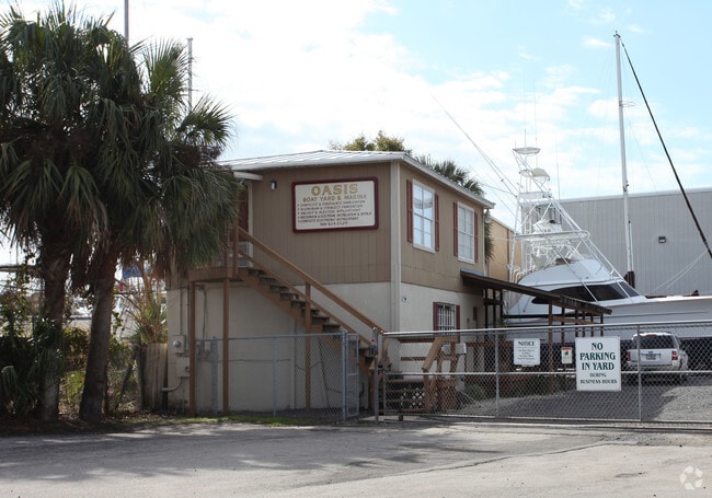

Property Detail
256 Riberia St
Jacksonville, FL
MARSH LOTS WEST OF RIBERIA ST (3)(4)(1-1) PTS OF LOT 3 960FT ON SAN SEBASTIAN RIVER & STRIP FROM CITY ADJ TO RIBERIA ST & S 1/2 0F VACA SOUTH ST FROM COSA ORD #622 OR1377/312 & 1942/1906(Q/C)
213170-0000
ST. JOHNS
Transportnec
Florida
AE The base floodplain where base flood elevations are provided. AE Zones are now used on new format FIRMs instead of A1-A30 Zones.
3
2023
5.78 AC
2025
St Johns County
020400
Jacksonville (Florida)
1,508 SF
NEARBY LISTINGS FOR SALE OR LEASE
DEMOGRAPHICS near 256 Riberia St
1 mile
3 mile
5 mile
2025 Total Population
5,059
42,949
86,628
2030 Population
5,964
49,948
101,098
Pop Growth 2025-2030
+ 17.89%
+ 16.30%
+ 16.70%
Average Age
45
45
46
2025 Total Households
2,170
18,876
37,744
HH Growth 2025-2030
+ 18.99%
+ 16.76%
+ 17.16%
Median Household Inc
$78,448
$74,450
$78,425
Avg Household Size
2.00
2.20
2.20
2025 Avg HH Vehicles
1.00
2.00
2.00
Median Home Value
$610,215
$427,336
$452,716
Median Year Built
1955
1994
1996
Nearby Places
Map Layers
Map Styles
 Street
 Aerial
Transit
 Traffic
 Biking
Places
Listings with unknown addresses are not visible on the map
- Restaurants
- Banks
- Shops
- Fitness
- Groceries
Nearby Properties
Address
Land Use
TOTAL SIZE
Lot Size
Zoning
Address
Land Use
TOTAL SIZE
Lot Size
Zoning
322,553 SF
10.54 AC
Address
Land Use
TOTAL SIZE
Lot Size
Zoning
657,013 SF
77.07 AC
Address
Land Use
TOTAL SIZE
Lot Size
Zoning
44,656 SF
16.56 AC
Address
Land Use
TOTAL SIZE
Lot Size
Zoning
323,748 SF
4.62 AC
Address
Land Use
TOTAL SIZE
Lot Size
Zoning
532,530 SF
25.80 AC
CG
Address
Land Use
TOTAL SIZE
Lot Size
Zoning
274,007 SF
22.11 AC
Address
Land Use
TOTAL SIZE
Lot Size
Zoning
311,794 SF
39.89 AC
Address
Land Use
TOTAL SIZE
Lot Size
Zoning
209,356 SF
12.88 AC
RG-O
Address
Land Use
TOTAL SIZE
Lot Size
Zoning
167,115 SF
1.58 AC
TCMU
Address
Land Use
TOTAL SIZE
Lot Size
Zoning
320,571 SF
15.91 AC
Address
Land Use
TOTAL SIZE
Lot Size
Zoning
Address
Land Use
TOTAL SIZE
Lot Size
Zoning
262,617 SF
37.08 AC
PUD
Address
Land Use
TOTAL SIZE
Lot Size
Zoning
53,451 SF
1.23 AC
CM2
Address
Land Use
TOTAL SIZE
Lot Size
Zoning
100,199 SF
1.56 AC
Address
Land Use
TOTAL SIZE
Lot Size
Zoning
154,685 SF
82.60 AC
RS3
Address
Land Use
TOTAL SIZE
Lot Size
Zoning
130,186 SF
21.74 AC
CG
Address
Land Use
TOTAL SIZE
Lot Size
Zoning
115,134 SF
4.54 AC
Address
Land Use
TOTAL SIZE
Lot Size
Zoning
53,172 SF
2.65 AC
Address
Land Use
TOTAL SIZE
Lot Size
Zoning
107,633 SF
19.47 AC
OR
Address
Land Use
TOTAL SIZE
Lot Size
Zoning
76,020 SF
2.22 AC
CM2
Address
Land Use
TOTAL SIZE
Lot Size
Zoning
117,811 SF
1.17 AC
HP4
Address
Land Use
TOTAL SIZE
Lot Size
Zoning
119,853 SF
21.34 AC
Address
Land Use
TOTAL SIZE
Lot Size
Zoning
161,211 SF
21.70 AC
PUD
Address
Land Use
TOTAL SIZE
Lot Size
Zoning
138,677 SF
4.08 AC
Address
Land Use
TOTAL SIZE
Lot Size
Zoning
167,306 SF
17.02 AC
CG
Address
Land Use
TOTAL SIZE
Lot Size
Zoning
47,385 SF
12.36 AC
Address
Land Use
TOTAL SIZE
Lot Size
Zoning
60,003 SF
0.79 AC
Address
Land Use
TOTAL SIZE
Lot Size
Zoning
60,889 SF
2.57 AC
CHT
Address
Land Use
TOTAL SIZE
Lot Size
Zoning
56,272 SF
1.36 AC
Address
Land Use
TOTAL SIZE
Lot Size
Zoning
The World's #1 Commercial Real Estate Marketplace
Connect with us
© 2026 CoStar Group
The information above has been obtained from sources believed reliable. While we do not doubt its accuracy we have not verified it and make no guarantee, warranty or representation about it. It is your responsibility to independently confirm its accuracy and completeness. Any projections, opinions, assumptions, or estimates used are for example only and do not represent the current or future performance of the property. The value of this transaction to you depends on tax and other factors which should be evaluated by your tax, financial, and legal advisors. You and your advisors should conduct a careful, independent investigation of the property to determine to your satisfaction the suitability of the property for your needs.