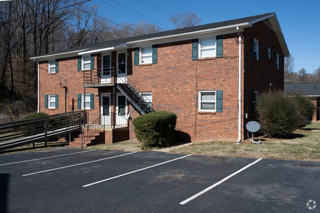
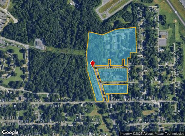
Property Record
2560 La Deara Crest Ln, Winston Salem, NC 27105

NEARBY LISTINGS FOR SALE OR LEASE
Property Detail
2560 La Deara Crest Ln
Winston-Salem, NC
Ladeara Crest Estates
6836-86-9223
LADEARA CREST ESTATES LO:104 BL:2950 BU:1
Apartment
Forsyth
AE
North Carolina
3710683600J
104
2024
24.21 AC
2025
Ledera Crest
001602
Greensboro/Winston-Salem
32,754 SF
DEMOGRAPHICS near 2560 La Deara Crest Ln
1 Mile
3 Mile
5 Mile
2024 Total Population
7,631
55,201
141,619
2029 Population
8,097
58,037
148,061
Pop Growth 2024-2029
+ 6.11%
+ 5.14%
+ 4.55%
Average Age
36
37
37
2024 Total Households
3,001
22,205
56,655
HH Growth 2024-2029
+ 6.10%
+ 5.39%
+ 4.72%
Median Household Inc
$23,295
$37,815
$44,157
Avg Household Size
2.40
2.20
2.30
2024 Avg HH Vehicles
1.00
1.00
2.00
Median Home Value
$79,642
$141,996
$177,820
Median Year Built
1965
1970
1971
Nearby Places
Map Layers
Map Styles
 Street
 Aerial
- Restaurants
- Banks
- Shops
- Fitness
- Groceries
PUBLIC TRANSPORTATION
AIRPORT
Piedmont Triad International
DRIVE
WALK
Distance
Piedmont Triad International
37 min
20.6 mi
Freight Ports
Virginia Port Authority - Richmond
DRIVE
WALK
Distance
Virginia Port Authority - Richmond
263 min
224.2 mi
SALE & LEASE HISTORY
LISTING DATE
SALE/LEASE

Aug 13, 2020
For Sale
Nearby Properties
Address
Land Use
TOTAL SIZE
Lot Size
Zoning
Address
Land Use
TOTAL SIZE
Lot Size
Zoning
368,715 SF
4.11 AC
CI
Address
Land Use
TOTAL SIZE
Lot Size
Zoning
205,729 SF
2.35 AC
CI
Address
Land Use
TOTAL SIZE
Lot Size
Zoning
244,516 SF
4.42 AC
CI
Address
Land Use
TOTAL SIZE
Lot Size
Zoning
297,475 SF
3.06 AC
CI-S
Address
Land Use
TOTAL SIZE
Lot Size
Zoning
315,590 SF
2 AC
CB
Address
Land Use
TOTAL SIZE
Lot Size
Zoning
156,507 SF
NULL
Address
Land Use
TOTAL SIZE
Lot Size
Zoning
121,886 SF
3.92 AC
PB-S
Address
Land Use
TOTAL SIZE
Lot Size
Zoning
436,579 SF
72.65 AC
RM8-S
Address
Land Use
TOTAL SIZE
Lot Size
Zoning
100 SF
37.41 AC
C,H
Address
Land Use
TOTAL SIZE
Lot Size
Zoning
202,752 SF
3.43 AC
PB-L
Address
Land Use
TOTAL SIZE
Lot Size
Zoning
352,549 SF
2.30 AC
CB WO
Address
Land Use
TOTAL SIZE
Lot Size
Zoning
140,472 SF
1.33 AC
CB WO
Address
Land Use
TOTAL SIZE
Lot Size
Zoning
283,831 SF
559.85 AC
GI,RS9
Address
Land Use
TOTAL SIZE
Lot Size
Zoning
122,900 SF
49.54 AC
GB
Address
Land Use
TOTAL SIZE
Lot Size
Zoning
153,315 SF
2.07 AC
CI
Address
Land Use
TOTAL SIZE
Lot Size
Zoning
195,551 SF
2.07 AC
CI
Address
Land Use
TOTAL SIZE
Lot Size
Zoning
200 SF
8.16 AC
PB-S
Address
Land Use
TOTAL SIZE
Lot Size
Zoning
154,655 SF
0.76 AC
CI
Address
Land Use
TOTAL SIZE
Lot Size
Zoning
264,904 SF
21.63 AC
GB
Address
Land Use
TOTAL SIZE
Lot Size
Zoning
169,443 SF
33.02 AC
GB
Address
Land Use
TOTAL SIZE
Lot Size
Zoning
112,000 SF
15.57 AC
IP
Address
Land Use
TOTAL SIZE
Lot Size
Zoning
449,945 SF
20.96 AC
LI
Address
Land Use
TOTAL SIZE
Lot Size
Zoning
205,979 SF
1.73 AC
CB WO
Address
Land Use
TOTAL SIZE
Lot Size
Zoning
207,203 SF
4.26 AC
PB
Address
Land Use
TOTAL SIZE
Lot Size
Zoning
70,376 SF
2.86 AC
PB-S
Address
Land Use
TOTAL SIZE
Lot Size
Zoning
106,204 SF
1.13 AC
CI
Address
Land Use
TOTAL SIZE
Lot Size
Zoning
124,134 SF
2.14 AC
CB WO
Address
Land Use
TOTAL SIZE
Lot Size
Zoning
121,925 SF
1.49 AC
GO
Address
Land Use
TOTAL SIZE
Lot Size
Zoning
373,394 SF
37.51 AC
GI
Address
Land Use
TOTAL SIZE
Lot Size
Zoning
119,130 SF
5.84 AC
GB-L
The World's #1 Commercial Real Estate Marketplace
Connect with us
© 2026 CoStar Group
The information above has been obtained from sources believed reliable. While we do not doubt its accuracy we have not verified it and make no guarantee, warranty or representation about it. It is your responsibility to independently confirm its accuracy and completeness. Any projections, opinions, assumptions, or estimates used are for example only and do not represent the current or future performance of the property. The value of this transaction to you depends on tax and other factors which should be evaluated by your tax, financial, and legal advisors. You and your advisors should conduct a careful, independent investigation of the property to determine to your satisfaction the suitability of the property for your needs.