Property Record
25605 Brewer Dr N, Ardmore, AL 35739


Save to a Folder
{{folder.Name}}
{{folder.ListingIds.length}} Properties
{{folder.ListingIds.length}} Property
Create a New Folder
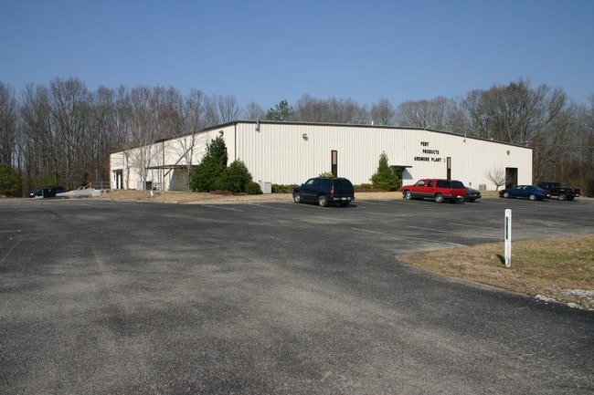
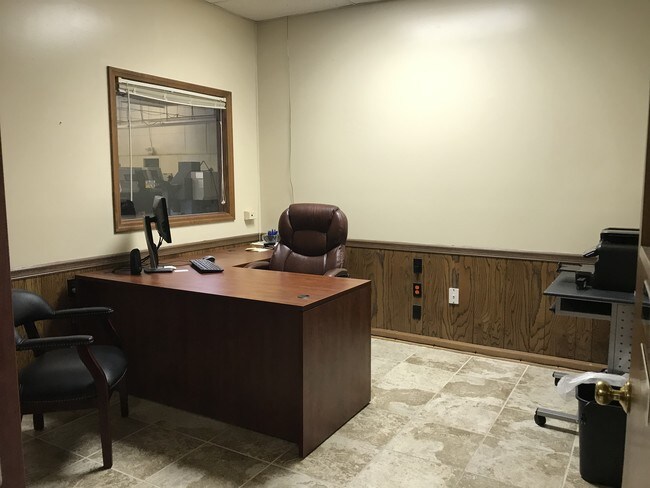
Property Detail
25605 Brewer Dr N
01-03-05-0-000-008.005
COMM SE COR OF SW/4 N 1000 POB W 392.79 N 305.19 E 392.79 S 305.19TO POB
Manufacturinglight
LIMESTONE
B and X Area of moderate flood hazard, usually the area between the limits of the 100-year and 500-year floods.
Alabama
2025
2.78 AC
2025
Outlying Limestone County
020103
Huntsville
22,500 SF
Huntsville, AL
NEARBY LISTINGS FOR SALE OR LEASE
-
-
View all Ardmore listings for lease on LoopNet.com
DEMOGRAPHICS near 25605 Brewer Dr N
1 mile
3 mile
5 mile
2025 Total Population
624
6,194
11,093
2030 Population
699
6,794
12,206
Pop Growth 2025-2030
+ 12.02%
+ 9.69%
+ 10.03%
Average Age
41
42
42
2025 Total Households
255
2,558
4,498
HH Growth 2025-2030
+ 12.16%
+ 9.81%
+ 10.18%
Median Household Inc
$79,687
$71,546
$73,129
Avg Household Size
2.50
2.40
2.40
2025 Avg HH Vehicles
2.00
2.00
2.00
Median Home Value
$245,000
$239,681
$242,294
Median Year Built
1993
1991
1994
Nearby Places
Map Layers
Map Styles
 Street
 Aerial
Layers
 Traffic
 Biking
Places
Listings with unknown addresses are not visible on the map
- Restaurants
- Banks
- Shops
- Fitness
- Groceries
PUBLIC TRANSPORTATION
AIRPORT
Huntsville International-Carl T Jones Field
Drive
Walk
Distance
Huntsville International-Carl T Jones Field
46 min
37.0 mi
SALE & LEASE HISTORY
LISTING DATE
SALE/LEASE

Sep 23, 2016
For Sale
Jun 12, 2019
For Lease
Nearby Properties
Address
Land Use
TOTAL SIZE
Lot Size
Zoning
Address
Land Use
TOTAL SIZE
Lot Size
Zoning
33,194 SF
9.19 AC
Address
Land Use
TOTAL SIZE
Lot Size
Zoning
5.30 AC
Address
Land Use
TOTAL SIZE
Lot Size
Zoning
1,174 SF
5.30 AC
Address
Land Use
TOTAL SIZE
Lot Size
Zoning
75.76 AC
Address
Land Use
TOTAL SIZE
Lot Size
Zoning
21.62 AC
Address
Land Use
TOTAL SIZE
Lot Size
Zoning
24,973 SF
3.80 AC
Address
Land Use
TOTAL SIZE
Lot Size
Zoning
9,120 SF
2.57 AC
Address
Land Use
TOTAL SIZE
Lot Size
Zoning
42,890 SF
9.80 AC
Address
Land Use
TOTAL SIZE
Lot Size
Zoning
34,662 SF
4.87 AC
Address
Land Use
TOTAL SIZE
Lot Size
Zoning
36,000 SF
5.70 AC
Address
Land Use
TOTAL SIZE
Lot Size
Zoning
1,420 SF
5.69 AC
Address
Land Use
TOTAL SIZE
Lot Size
Zoning
73,788 SF
8.50 AC
Address
Land Use
TOTAL SIZE
Lot Size
Zoning
13,912 SF
1.40 AC
Address
Land Use
TOTAL SIZE
Lot Size
Zoning
7,904 SF
3.09 AC
Address
Land Use
TOTAL SIZE
Lot Size
Zoning
9,779 SF
0.21 AC
Address
Land Use
TOTAL SIZE
Lot Size
Zoning
44,365 SF
8.50 AC
Address
Land Use
TOTAL SIZE
Lot Size
Zoning
18,240 SF
8.50 AC
Address
Land Use
TOTAL SIZE
Lot Size
Zoning
7,320 SF
3.14 AC
Address
Land Use
TOTAL SIZE
Lot Size
Zoning
56,315 SF
5.20 AC
Address
Land Use
TOTAL SIZE
Lot Size
Zoning
4,022 SF
3.30 AC
Address
Land Use
TOTAL SIZE
Lot Size
Zoning
17,388 SF
1.80 AC
Address
Land Use
TOTAL SIZE
Lot Size
Zoning
5,412 SF
1.99 AC
Address
Land Use
TOTAL SIZE
Lot Size
Zoning
4,200 SF
1.50 AC
Address
Land Use
TOTAL SIZE
Lot Size
Zoning
5,260 SF
2.25 AC
Address
Land Use
TOTAL SIZE
Lot Size
Zoning
39,400 SF
9.30 AC
Address
Land Use
TOTAL SIZE
Lot Size
Zoning
11,626 SF
14 AC
Address
Land Use
TOTAL SIZE
Lot Size
Zoning
5,477 SF
0.77 AC
Address
Land Use
TOTAL SIZE
Lot Size
Zoning
10,222 SF
2.50 AC
Address
Land Use
TOTAL SIZE
Lot Size
Zoning
504 SF
2.10 AC
Address
Land Use
TOTAL SIZE
Lot Size
Zoning
14,000 SF
4 AC
The World's #1 Commercial Real Estate Marketplace
Connect with us
© 2026 CoStar Group
The information above has been obtained from sources believed reliable. While we do not doubt its accuracy we have not verified it and make no guarantee, warranty or representation about it. It is your responsibility to independently confirm its accuracy and completeness. Any projections, opinions, assumptions, or estimates used are for example only and do not represent the current or future performance of the property. The value of this transaction to you depends on tax and other factors which should be evaluated by your tax, financial, and legal advisors. You and your advisors should conduct a careful, independent investigation of the property to determine to your satisfaction the suitability of the property for your needs.