Property Record
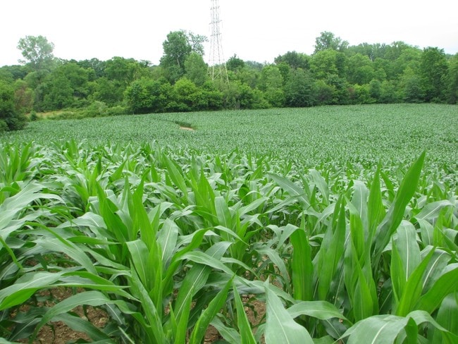
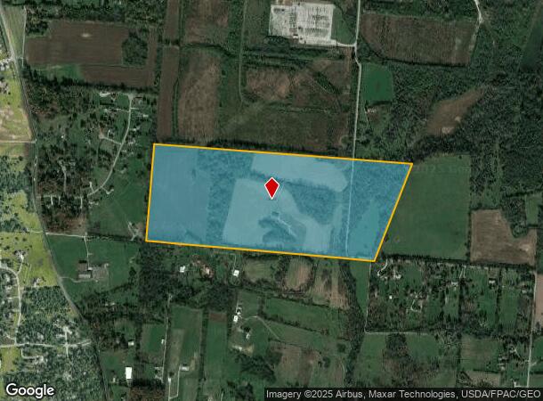
2561 Linebaugh Rd, Xenia, OH 45385
NEARBY LISTINGS FOR SALE OR LEASE
Property Detail
2561 Linebaugh Rd
B03-0002-0040-0-0004-00
7/3/2011 100.892AC LINEBAUGH RD
Agriculturalland
Greene
AE
Ohio
39057C0040E
100.89 AC
2024
Southeast Dayton
2024
Cincinnati/Dayton
210603
Dayton, OH
DEMOGRAPHICS near 2561 Linebaugh Rd
1 Mile
3 Mile
5 Mile
2024 Total Population
795
17,471
70,062
2029 Population
817
17,976
72,109
Pop Growth 2024-2029
+ 2.77%
+ 2.89%
+ 2.92%
Average Age
37
40
40
2024 Total Households
257
7,211
29,287
HH Growth 2024-2029
+ 2.33%
+ 3.01%
+ 3.03%
Median Household Inc
$152,193
$100,913
$78,751
Avg Household Size
3.10
2.40
2.30
2024 Avg HH Vehicles
2.00
2.00
2.00
Median Home Value
$334,408
$272,490
$212,406
Median Year Built
1996
1994
1978
Nearby Places
Map Layers
Map Styles
 Street
 Aerial
- Restaurants
- Banks
- Shops
- Fitness
- Groceries
PUBLIC TRANSPORTATION
AIRPORT
James M Cox Dayton International
DRIVE
WALK
Distance
James M Cox Dayton International
38 min
25.2 mi
Freight Ports
Port of Toledo
DRIVE
WALK
Distance
Port of Toledo
197 min
165.5 mi
SALE & LEASE HISTORY
LISTING DATE
SALE/LEASE

Mar 29, 2017
For Sale
Nearby Properties
Address
Land Use
TOTAL SIZE
Lot Size
Zoning
Address
Land Use
TOTAL SIZE
Lot Size
Zoning
3,038 SF
13.49 AC
RPUD936
Address
Land Use
TOTAL SIZE
Lot Size
Zoning
57,816 SF
9.15 AC
PD1
Address
Land Use
TOTAL SIZE
Lot Size
Zoning
594,070 SF
43.95 AC
AG
Address
Land Use
TOTAL SIZE
Lot Size
Zoning
45,204 SF
14.92 AC
PD1
Address
Land Use
TOTAL SIZE
Lot Size
Zoning
163,780 SF
36.93 AC
PARK
Address
Land Use
TOTAL SIZE
Lot Size
Zoning
278,290 SF
18.87 AC
AG
Address
Land Use
TOTAL SIZE
Lot Size
Zoning
6.13 AC
Address
Land Use
TOTAL SIZE
Lot Size
Zoning
14,496 SF
0.64 AC
2
Address
Land Use
TOTAL SIZE
Lot Size
Zoning
46,656 SF
10.35 AC
PD1
Address
Land Use
TOTAL SIZE
Lot Size
Zoning
84,032 SF
10.08 AC
RPUD936
Address
Land Use
TOTAL SIZE
Lot Size
Zoning
51,279 SF
2.58 AC
PD1
Address
Land Use
TOTAL SIZE
Lot Size
Zoning
24,512 SF
6.73 AC
PD1
Address
Land Use
TOTAL SIZE
Lot Size
Zoning
46,005 SF
9.33 AC
PD4
Address
Land Use
TOTAL SIZE
Lot Size
Zoning
18,230 SF
121.78 AC
RPUD936
Address
Land Use
TOTAL SIZE
Lot Size
Zoning
17,600 SF
16.43 AC
Address
Land Use
TOTAL SIZE
Lot Size
Zoning
24,512 SF
5.75 AC
PD1
Address
Land Use
TOTAL SIZE
Lot Size
Zoning
1,526 SF
627.09 AC
Address
Land Use
TOTAL SIZE
Lot Size
Zoning
3,456 SF
5.66 AC
PD1
Address
Land Use
TOTAL SIZE
Lot Size
Zoning
2,440 SF
405.31 AC
Address
Land Use
TOTAL SIZE
Lot Size
Zoning
57.35 AC
RPUD936
Address
Land Use
TOTAL SIZE
Lot Size
Zoning
76,636 SF
7.40 AC
R4
Address
Land Use
TOTAL SIZE
Lot Size
Zoning
101,824 SF
6.13 AC
R4
Address
Land Use
TOTAL SIZE
Lot Size
Zoning
113.37 AC
Address
Land Use
TOTAL SIZE
Lot Size
Zoning
23,759 SF
25.60 AC
PARK
Address
Land Use
TOTAL SIZE
Lot Size
Zoning
53.70 AC
PD2
Address
Land Use
TOTAL SIZE
Lot Size
Zoning
93,733 SF
7.83 AC
I-R
Address
Land Use
TOTAL SIZE
Lot Size
Zoning
54,900 SF
4 AC
R-1
Address
Land Use
TOTAL SIZE
Lot Size
Zoning
3,200 SF
167.63 AC
Address
Land Use
TOTAL SIZE
Lot Size
Zoning
9,481 SF
71.97 AC
Address
Land Use
TOTAL SIZE
Lot Size
Zoning
2,016 SF
7.08 AC
PD1
The World's #1 Commercial Real Estate Marketplace
Connect with us
© 2025 CoStar Group
The information above has been obtained from sources believed reliable. While we do not doubt its accuracy we have not verified it and make no guarantee, warranty or representation about it. It is your responsibility to independently confirm its accuracy and completeness. Any projections, opinions, assumptions, or estimates used are for example only and do not represent the current or future performance of the property. The value of this transaction to you depends on tax and other factors which should be evaluated by your tax, financial, and legal advisors. You and your advisors should conduct a careful, independent investigation of the property to determine to your satisfaction the suitability of the property for your needs.