Property Record
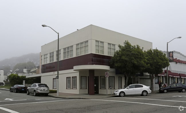
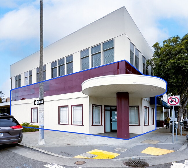
2560 Ocean Ave, San Francisco, CA 94132

Current Lease Availabilities
NEARBY LISTINGS FOR SALE OR LEASE
Property Detail
2560 Ocean Ave
San Francisco-Redwood City-South San Francisco, CA
San Francisco
7225-014C
California
Storemultistory
14c
2024
0.10 AC
2025
Southern City
033201
San Francisco
7,260 SF
DEMOGRAPHICS near 2560 Ocean Ave
1 Mile
3 Mile
5 Mile
2024 Total Population
32,865
321,764
755,235
2029 Population
30,255
295,880
698,903
Pop Growth 2024-2029
(7.94%)
(8.04%)
(7.46%)
Average Age
44
43
43
2024 Total Households
11,498
116,218
295,234
HH Growth 2024-2029
(8.33%)
(8.40%)
(7.85%)
Median Household Inc
$136,076
$131,111
$122,626
Avg Household Size
2.70
2.70
2.40
2024 Avg HH Vehicles
2.00
2.00
1.00
Median Home Value
$1,128,068
$1,100,448
$1,088,449
Median Year Built
1947
1948
1949
Nearby Places
Map Layers
Map Styles
 Street
 Aerial
- Restaurants
- Banks
- Shops
- Fitness
- Groceries
PUBLIC TRANSPORTATION
TRANSIT/SUBWAY
Ocean (M Ocean View - San Francisco Municipal Railway (MUNI Metro))
DRIVE
WALK
Distance
Ocean (M Ocean View - San Francisco Municipal Railway (MUNI Metro))
1 min
1 min
0.0 mi
Junipero Serra and Ocean (K Ingleside - San Francisco Municipal Railway (MUNI Metro))
DRIVE
WALK
Distance
Junipero Serra and Ocean (K Ingleside - San Francisco Municipal Railway (MUNI Metro))
2 min
2 min
0.1 mi
Eucalyptus Drive (M Ocean View - San Francisco Municipal Railway (MUNI Metro))
DRIVE
WALK
Distance
Eucalyptus Drive (M Ocean View - San Francisco Municipal Railway (MUNI Metro))
1 min
3 min
0.2 mi
Eucalyptus (M Ocean View - San Francisco Municipal Railway (MUNI Metro))
DRIVE
WALK
Distance
Eucalyptus (M Ocean View - San Francisco Municipal Railway (MUNI Metro))
1 min
3 min
0.2 mi
Ocean Ave & San Leandro Way (K Ingleside - San Francisco Municipal Railway (MUNI Metro))
DRIVE
WALK
Distance
Ocean Ave & San Leandro Way (K Ingleside - San Francisco Municipal Railway (MUNI Metro))
2 min
5 min
0.3 mi
COMMUTER RAIL
22nd Street (Caltrain - Caltrain (Caltrain))
DRIVE
WALK
Distance
22nd Street (Caltrain - Caltrain (Caltrain))
16 min
8.2 mi
Bayshore (Caltrain - Caltrain (Caltrain))
DRIVE
WALK
Distance
Bayshore (Caltrain - Caltrain (Caltrain))
14 min
8.7 mi
AIRPORT
San Francisco International
DRIVE
WALK
Distance
San Francisco International
17 min
12.3 mi
Metro Oakland International
DRIVE
WALK
Distance
Metro Oakland International
39 min
28.2 mi
Freight Ports
Port of San Francisco
DRIVE
WALK
Distance
Port of San Francisco
1 min
6.2 mi
Nearby Properties
Address
Land Use
TOTAL SIZE
Lot Size
Zoning
Address
Land Use
TOTAL SIZE
Lot Size
Zoning
411,904 SF
21.74 AC
C2
Address
Land Use
TOTAL SIZE
Lot Size
Zoning
346,710 SF
7.45 AC
RH2
Address
Land Use
TOTAL SIZE
Lot Size
Zoning
312,191 SF
2.74 AC
Address
Land Use
TOTAL SIZE
Lot Size
Zoning
447,674 SF
21.51 AC
Address
Land Use
TOTAL SIZE
Lot Size
Zoning
2.03 AC
C2
Address
Land Use
TOTAL SIZE
Lot Size
Zoning
88,900 SF
5.37 AC
NCS
Address
Land Use
TOTAL SIZE
Lot Size
Zoning
11.31 AC
RM2
Address
Land Use
TOTAL SIZE
Lot Size
Zoning
160,983 SF
1.84 AC
NC2
Address
Land Use
TOTAL SIZE
Lot Size
Zoning
90,539 SF
2.28 AC
RH2
Address
Land Use
TOTAL SIZE
Lot Size
Zoning
Address
Land Use
TOTAL SIZE
Lot Size
Zoning
73,491 SF
4.48 AC
C2
Address
Land Use
TOTAL SIZE
Lot Size
Zoning
12,555 SF
0.74 AC
NCS
Address
Land Use
TOTAL SIZE
Lot Size
Zoning
146,036 SF
0.49 AC
RH3
Address
Land Use
TOTAL SIZE
Lot Size
Zoning
176,000 SF
1.64 AC
C2
Address
Land Use
TOTAL SIZE
Lot Size
Zoning
54,131 SF
1.75 AC
C2
Address
Land Use
TOTAL SIZE
Lot Size
Zoning
76,000 SF
1.48 AC
RM4
Address
Land Use
TOTAL SIZE
Lot Size
Zoning
194,477 SF
11.37 AC
RH1
Address
Land Use
TOTAL SIZE
Lot Size
Zoning
67,432 SF
4.55 AC
CL00C1
Address
Land Use
TOTAL SIZE
Lot Size
Zoning
87,525 SF
1.65 AC
RM1
Address
Land Use
TOTAL SIZE
Lot Size
Zoning
113,782 SF
2.90 AC
Address
Land Use
TOTAL SIZE
Lot Size
Zoning
205,770 SF
3.37 AC
RM4
Address
Land Use
TOTAL SIZE
Lot Size
Zoning
6.80 AC
RM1
Address
Land Use
TOTAL SIZE
Lot Size
Zoning
81,756 SF
5.39 AC
RH1D
Address
Land Use
TOTAL SIZE
Lot Size
Zoning
257,754 SF
1.37 AC
Address
Land Use
TOTAL SIZE
Lot Size
Zoning
63,943 SF
0.77 AC
Address
Land Use
TOTAL SIZE
Lot Size
Zoning
89,274 SF
0.58 AC
NC3
Address
Land Use
TOTAL SIZE
Lot Size
Zoning
66,986 SF
4.91 AC
NCS
Address
Land Use
TOTAL SIZE
Lot Size
Zoning
2.01 AC
RM1
Address
Land Use
TOTAL SIZE
Lot Size
Zoning
136,892 SF
0.96 AC
Address
Land Use
TOTAL SIZE
Lot Size
Zoning
6.18 AC
RM1
The World's #1 Commercial Real Estate Marketplace
Connect with us
© 2025 CoStar Group
The information above has been obtained from sources believed reliable. While we do not doubt its accuracy we have not verified it and make no guarantee, warranty or representation about it. It is your responsibility to independently confirm its accuracy and completeness. Any projections, opinions, assumptions, or estimates used are for example only and do not represent the current or future performance of the property. The value of this transaction to you depends on tax and other factors which should be evaluated by your tax, financial, and legal advisors. You and your advisors should conduct a careful, independent investigation of the property to determine to your satisfaction the suitability of the property for your needs.