Property Record
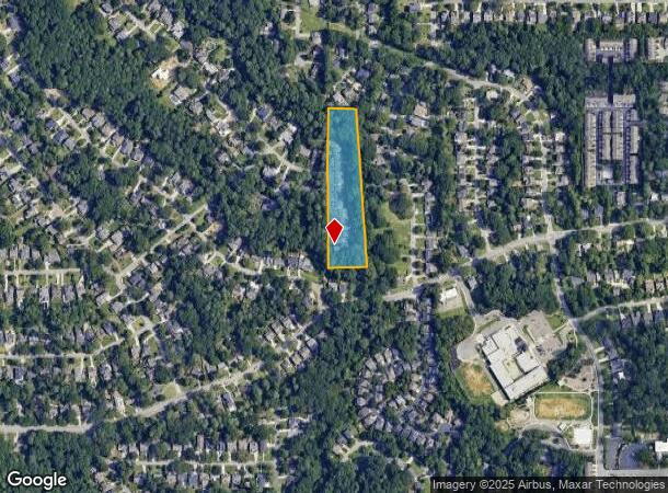
2569 Redding Rd Ne, Brookhaven, GA 30319

NEARBY LISTINGS FOR SALE OR LEASE
Property Detail
2569 Redding Rd Ne
18-243-14-068
4 X 328 X 145 X 20 X 938 X 230 X 614 4.27AC 4-5-96
Apartment
DeKalb
AE
Georgia
13089C0052K
68
2025
4.26 AC
2025
Ashford Park
021412
Atlanta
50,428 SF
Atlanta-Sandy Springs-Roswell, GA
DEMOGRAPHICS near 2569 Redding Rd Ne
1 Mile
3 Mile
5 Mile
2024 Total Population
14,384
120,932
323,605
2029 Population
14,273
121,310
327,129
Pop Growth 2024-2029
(0.77%)
+ 0.31%
+ 1.09%
Average Age
34
37
38
2024 Total Households
5,822
53,505
148,543
HH Growth 2024-2029
(1.12%)
+ 0.41%
+ 1.39%
Median Household Inc
$129,356
$99,217
$95,528
Avg Household Size
2.40
2.20
2.10
2024 Avg HH Vehicles
2.00
2.00
2.00
Median Home Value
$665,912
$565,869
$505,259
Median Year Built
1990
1991
1989
Nearby Places
Map Layers
Map Styles
 Street
 Aerial
- Restaurants
- Banks
- Shops
- Fitness
- Groceries
PUBLIC TRANSPORTATION
COMMUTER RAIL
Atlanta (Crescent - Amtrak)
DRIVE
WALK
Distance
Atlanta (Crescent - Amtrak)
15 min
8.1 mi
AIRPORT
Hartsfield - Jackson Atlanta International
DRIVE
WALK
Distance
Hartsfield - Jackson Atlanta International
33 min
21.3 mi
Freight Ports
Georgia Ports - Savannah
DRIVE
WALK
Distance
Georgia Ports - Savannah
296 min
260.6 mi
Nearby Properties
Address
Land Use
TOTAL SIZE
Lot Size
Zoning
Address
Land Use
TOTAL SIZE
Lot Size
Zoning
11,126,925 SF
43.33 AC
C3
Address
Land Use
TOTAL SIZE
Lot Size
Zoning
12,600 SF
508.30 AC
M
Address
Land Use
TOTAL SIZE
Lot Size
Zoning
3,356,268 SF
14.72 AC
C3
Address
Land Use
TOTAL SIZE
Lot Size
Zoning
844,000 SF
2.33 AC
PDMU
Address
Land Use
TOTAL SIZE
Lot Size
Zoning
169,435 SF
76.18 AC
M
Address
Land Use
TOTAL SIZE
Lot Size
Zoning
1,242,520 SF
3.38 AC
PDMU
Address
Land Use
TOTAL SIZE
Lot Size
Zoning
1,233,815 SF
2.18 AC
PDMU
Address
Land Use
TOTAL SIZE
Lot Size
Zoning
598,962 SF
4.50 AC
PDOC
Address
Land Use
TOTAL SIZE
Lot Size
Zoning
899,673 SF
2.15 AC
PDMU
Address
Land Use
TOTAL SIZE
Lot Size
Zoning
188,648 SF
4.39 AC
X
Address
Land Use
TOTAL SIZE
Lot Size
Zoning
1,006,124 SF
2.97 AC
RG4C
Address
Land Use
TOTAL SIZE
Lot Size
Zoning
2,820,296 SF
9.58 AC
RG5
Address
Land Use
TOTAL SIZE
Lot Size
Zoning
458,822 SF
2.86 AC
RG2
Address
Land Use
TOTAL SIZE
Lot Size
Zoning
299,993 SF
4.72 AC
I1
Address
Land Use
TOTAL SIZE
Lot Size
Zoning
863,826 SF
3.79 AC
C4
Address
Land Use
TOTAL SIZE
Lot Size
Zoning
213,408 SF
6.35 AC
I1
Address
Land Use
TOTAL SIZE
Lot Size
Zoning
389,560 SF
4.01 AC
C1
Address
Land Use
TOTAL SIZE
Lot Size
Zoning
432,424 SF
3.87 AC
MC
Address
Land Use
TOTAL SIZE
Lot Size
Zoning
431,259 SF
48.90 AC
RM100
Address
Land Use
TOTAL SIZE
Lot Size
Zoning
386,058 SF
C3
Address
Land Use
TOTAL SIZE
Lot Size
Zoning
276,504 SF
3.40 AC
C1
Address
Land Use
TOTAL SIZE
Lot Size
Zoning
187,172 SF
7.22 AC
OI
Address
Land Use
TOTAL SIZE
Lot Size
Zoning
490,090 SF
2.27 AC
C3
Address
Land Use
TOTAL SIZE
Lot Size
Zoning
191,941 SF
3.02 AC
OCR
Address
Land Use
TOTAL SIZE
Lot Size
Zoning
257,989 SF
12.41 AC
OI
Address
Land Use
TOTAL SIZE
Lot Size
Zoning
713,717 SF
2.82 AC
R3
Address
Land Use
TOTAL SIZE
Lot Size
Zoning
574,125 SF
1.96 AC
C3
Address
Land Use
TOTAL SIZE
Lot Size
Zoning
131,793 SF
4.30 AC
X
Address
Land Use
TOTAL SIZE
Lot Size
Zoning
600,502 SF
4.46 AC
R3
Address
Land Use
TOTAL SIZE
Lot Size
Zoning
307,824 SF
16.40 AC
X
The World's #1 Commercial Real Estate Marketplace
Connect with us
© 2025 CoStar Group
The information above has been obtained from sources believed reliable. While we do not doubt its accuracy we have not verified it and make no guarantee, warranty or representation about it. It is your responsibility to independently confirm its accuracy and completeness. Any projections, opinions, assumptions, or estimates used are for example only and do not represent the current or future performance of the property. The value of this transaction to you depends on tax and other factors which should be evaluated by your tax, financial, and legal advisors. You and your advisors should conduct a careful, independent investigation of the property to determine to your satisfaction the suitability of the property for your needs.