Property Record
213 Main Rd, Akron, NY 14001
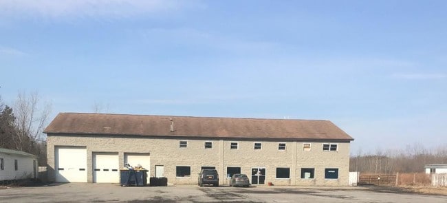
This Property Is For Sale
NEARBY LISTINGS FOR SALE OR LEASE
Property Detail
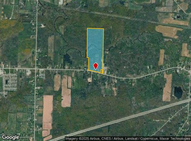
213 Main Rd
Batavia, NY
Genesee
184289-014-000-0001-075-001
New York
Ruralagriculturalresidence
82.90 AC
A
Rochester Other Areas
36029C0280H
Other Market Areas
2,226 SF
DEMOGRAPHICS near 213 Main Rd
1 Mile
3 Mile
5 Mile
2024 Total Population
205
5,653
11,480
2029 Population
202
5,589
11,428
Pop Growth 2024-2029
(1.46%)
(1.13%)
(0.45%)
Average Age
46
45
44
2024 Total Households
89
2,559
4,985
HH Growth 2024-2029
(1.12%)
(1.17%)
(0.60%)
Median Household Inc
$65,000
$56,576
$64,139
Avg Household Size
2.30
2.20
2.30
2024 Avg HH Vehicles
2.00
2.00
2.00
Median Home Value
$203,125
$188,378
$205,355
Median Year Built
1972
1965
1970
Nearby Places
- Restaurants
- Banks
- Shops
- Fitness
- Groceries
PUBLIC TRANSPORTATION
AIRPORT
Buffalo Niagara International
DRIVE
WALK
Distance
Buffalo Niagara International
24 min
15.4 mi
Niagara Falls International
DRIVE
WALK
Distance
Niagara Falls International
49 min
30.7 mi
Freight Ports
Albany, NY Port
DRIVE
WALK
Distance
Albany, NY Port
311 min
265.8 mi
Nearby Properties
Address
Land Use
TOTAL SIZE
Lot Size
Zoning
Address
Land Use
TOTAL SIZE
Lot Size
Zoning
180,205 SF
22.80 AC
02 - SINGL
Address
Land Use
TOTAL SIZE
Lot Size
Zoning
Address
Land Use
TOTAL SIZE
Lot Size
Zoning
140,000 SF
27.40 AC
505
Address
Land Use
TOTAL SIZE
Lot Size
Zoning
1 AC
04 - FARM
Address
Land Use
TOTAL SIZE
Lot Size
Zoning
117,236 SF
9.80 AC
Address
Land Use
TOTAL SIZE
Lot Size
Zoning
114,656 SF
53.70 AC
Address
Land Use
TOTAL SIZE
Lot Size
Zoning
6,000 SF
40.17 AC
20
Address
Land Use
TOTAL SIZE
Lot Size
Zoning
14,128 SF
11.71 AC
07 - MIXED
Address
Land Use
TOTAL SIZE
Lot Size
Zoning
7,000 SF
1.50 AC
17
Address
Land Use
TOTAL SIZE
Lot Size
Zoning
11,420 SF
24.40 AC
Address
Land Use
TOTAL SIZE
Lot Size
Zoning
1 AC
04 - FARM
Address
Land Use
TOTAL SIZE
Lot Size
Zoning
7,120 SF
64.71 AC
06 - INDUS
Address
Land Use
TOTAL SIZE
Lot Size
Zoning
0.01 AC
17
Address
Land Use
TOTAL SIZE
Lot Size
Zoning
0.01 AC
Address
Land Use
TOTAL SIZE
Lot Size
Zoning
15,650 SF
42.39 AC
19
Address
Land Use
TOTAL SIZE
Lot Size
Zoning
3.91 AC
11
Address
Land Use
TOTAL SIZE
Lot Size
Zoning
0.01 AC
Address
Land Use
TOTAL SIZE
Lot Size
Zoning
14,674 SF
6.15 AC
17
Address
Land Use
TOTAL SIZE
Lot Size
Zoning
249,402 SF
16 AC
07 - MIXED
Address
Land Use
TOTAL SIZE
Lot Size
Zoning
Address
Land Use
TOTAL SIZE
Lot Size
Zoning
7,500 SF
0.64 AC
04 - FARM
Address
Land Use
TOTAL SIZE
Lot Size
Zoning
9,848 SF
16.30 AC
Address
Land Use
TOTAL SIZE
Lot Size
Zoning
31,636 SF
5.20 AC
05 - COMME
Address
Land Use
TOTAL SIZE
Lot Size
Zoning
5,616 SF
166.30 AC
08 - GOVER
Address
Land Use
TOTAL SIZE
Lot Size
Zoning
Address
Land Use
TOTAL SIZE
Lot Size
Zoning
8,702 SF
13.60 AC
01 - NOT Z
Address
Land Use
TOTAL SIZE
Lot Size
Zoning
10,266 SF
3.80 AC
03 - MULTI
Address
Land Use
TOTAL SIZE
Lot Size
Zoning
3,480 SF
42 AC
17
Address
Land Use
TOTAL SIZE
Lot Size
Zoning
7,000 SF
7.60 AC
17
The World's #1 Commercial Real Estate Marketplace
Connect with us
© 2025 CoStar Group
The information above has been obtained from sources believed reliable. While we do not doubt its accuracy we have not verified it and make no guarantee, warranty or representation about it. It is your responsibility to independently confirm its accuracy and completeness. Any projections, opinions, assumptions, or estimates used are for example only and do not represent the current or future performance of the property. The value of this transaction to you depends on tax and other factors which should be evaluated by your tax, financial, and legal advisors. You and your advisors should conduct a careful, independent investigation of the property to determine to your satisfaction the suitability of the property for your needs.