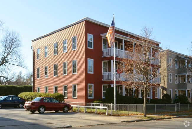
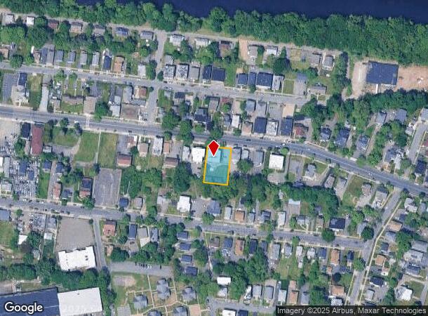
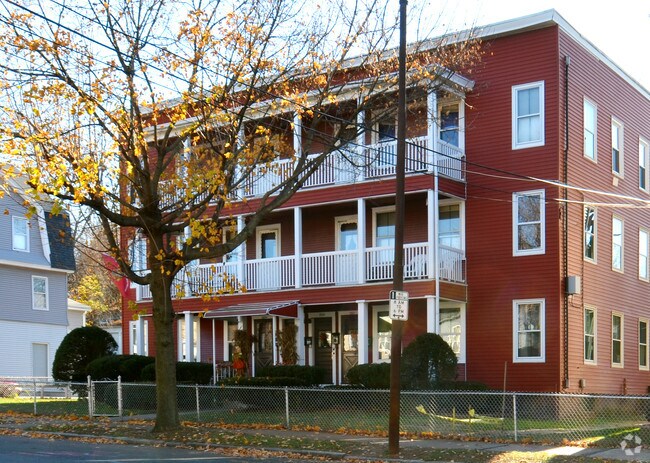
Property Record
257 Main St, Indian Orchard, MA 01151
NEARBY LISTINGS FOR SALE OR LEASE
-
-
View all Indian Orchard listings for sale on LoopNet.com
Property Detail
257 Main St
Apartment
Hampden
X
Massachusetts
25013C0236E
0.34 AC
2025
Indian Orchard
2025
Hartford
800102
Springfield, MA
9,868 SF
SPRI-008132-000000-000253
DEMOGRAPHICS near 257 Main St
1 Mile
3 Mile
5 Mile
2024 Total Population
11,557
54,055
139,358
2029 Population
11,328
53,358
137,025
Pop Growth 2024-2029
(1.98%)
(1.29%)
(1.67%)
Average Age
38
41
41
2024 Total Households
4,597
21,253
53,924
HH Growth 2024-2029
(2.07%)
(1.36%)
(1.74%)
Median Household Inc
$57,979
$61,633
$61,770
Avg Household Size
2.50
2.40
2.40
2024 Avg HH Vehicles
1.00
2.00
2.00
Median Home Value
$218,207
$237,220
$231,324
Median Year Built
1952
1961
1957
Nearby Places
Map Layers
Map Styles
 Street
 Aerial
- Restaurants
- Banks
- Shops
- Fitness
- Groceries
PUBLIC TRANSPORTATION
COMMUTER RAIL
Springfield (Amtrak Hartford Line - Amtrak, Hartford Line - Amtrak, Lake Shore Limited - Amtrak, Northeast Regional - Amtrak, Valley Flyer - Amtrak, Vermonter - Amtrak)
DRIVE
WALK
Distance
Springfield (Amtrak Hartford Line - Amtrak, Hartford Line - Amtrak, Lake Shore Limited - Amtrak, Northeast Regional - Amtrak, Valley Flyer - Amtrak, Vermonter - Amtrak)
12 min
7.2 mi
Holyoke Amtrak (Valley Flyer - Amtrak, Vermonter - Amtrak)
DRIVE
WALK
Distance
Holyoke Amtrak (Valley Flyer - Amtrak, Vermonter - Amtrak)
16 min
8.7 mi
AIRPORT
Bradley International
DRIVE
WALK
Distance
Bradley International
43 min
20.6 mi
Freight Ports
Port of New Haven
DRIVE
WALK
Distance
Port of New Haven
93 min
70.9 mi
Nearby Properties
Address
Land Use
TOTAL SIZE
Lot Size
Zoning
Address
Land Use
TOTAL SIZE
Lot Size
Zoning
89,312 SF
38.72 AC
R1
Address
Land Use
TOTAL SIZE
Lot Size
Zoning
56,576 SF
62.84 AC
SR1R4
Address
Land Use
TOTAL SIZE
Lot Size
Zoning
7.41 AC
I2
Address
Land Use
TOTAL SIZE
Lot Size
Zoning
45,444 SF
13.80 AC
Address
Land Use
TOTAL SIZE
Lot Size
Zoning
131,942 SF
40.30 AC
R1
Address
Land Use
TOTAL SIZE
Lot Size
Zoning
181,000 SF
34.48 AC
I1
Address
Land Use
TOTAL SIZE
Lot Size
Zoning
60.25 AC
Address
Land Use
TOTAL SIZE
Lot Size
Zoning
39,776 SF
8.16 AC
R2
Address
Land Use
TOTAL SIZE
Lot Size
Zoning
94,076 SF
63.12 AC
Address
Land Use
TOTAL SIZE
Lot Size
Zoning
105,000 SF
17.59 AC
SR1R3
Address
Land Use
TOTAL SIZE
Lot Size
Zoning
71,911 SF
9.19 AC
Address
Land Use
TOTAL SIZE
Lot Size
Zoning
762,340 SF
76.18 AC
SR1R2I
Address
Land Use
TOTAL SIZE
Lot Size
Zoning
99,792 SF
123.26 AC
S
Address
Land Use
TOTAL SIZE
Lot Size
Zoning
62,115 SF
1.69 AC
R1
Address
Land Use
TOTAL SIZE
Lot Size
Zoning
136,326 SF
65.19 AC
Address
Land Use
TOTAL SIZE
Lot Size
Zoning
15.31 AC
GB
Address
Land Use
TOTAL SIZE
Lot Size
Zoning
6.81 AC
S
Address
Land Use
TOTAL SIZE
Lot Size
Zoning
34 AC
Address
Land Use
TOTAL SIZE
Lot Size
Zoning
49,431 SF
6.19 AC
SR1B1
Address
Land Use
TOTAL SIZE
Lot Size
Zoning
34,732 SF
24.73 AC
R1
Address
Land Use
TOTAL SIZE
Lot Size
Zoning
3,534 SF
38.61 AC
R-3
Address
Land Use
TOTAL SIZE
Lot Size
Zoning
139,292 SF
12.54 AC
SB1I2
Address
Land Use
TOTAL SIZE
Lot Size
Zoning
18,774 SF
11.79 AC
S
Address
Land Use
TOTAL SIZE
Lot Size
Zoning
34.44 AC
I
Address
Land Use
TOTAL SIZE
Lot Size
Zoning
144,253 SF
32.19 AC
SR2B1
Address
Land Use
TOTAL SIZE
Lot Size
Zoning
13.02 AC
Address
Land Use
TOTAL SIZE
Lot Size
Zoning
123,200 SF
20 AC
R3
Address
Land Use
TOTAL SIZE
Lot Size
Zoning
133,600 SF
23.27 AC
R3
Address
Land Use
TOTAL SIZE
Lot Size
Zoning
116,670 SF
13 AC
GB
Address
Land Use
TOTAL SIZE
Lot Size
Zoning
199,007 SF
50.95 AC
S
The World's #1 Commercial Real Estate Marketplace
Connect with us
© 2025 CoStar Group
The information above has been obtained from sources believed reliable. While we do not doubt its accuracy we have not verified it and make no guarantee, warranty or representation about it. It is your responsibility to independently confirm its accuracy and completeness. Any projections, opinions, assumptions, or estimates used are for example only and do not represent the current or future performance of the property. The value of this transaction to you depends on tax and other factors which should be evaluated by your tax, financial, and legal advisors. You and your advisors should conduct a careful, independent investigation of the property to determine to your satisfaction the suitability of the property for your needs.