Property Record
257 Route 80, Killingworth, CT 06419

Save to a Folder
{{folder.Name}}
{{folder.ListingIds.length}} Properties
{{folder.ListingIds.length}} Property
Create a New Folder
Property Detail
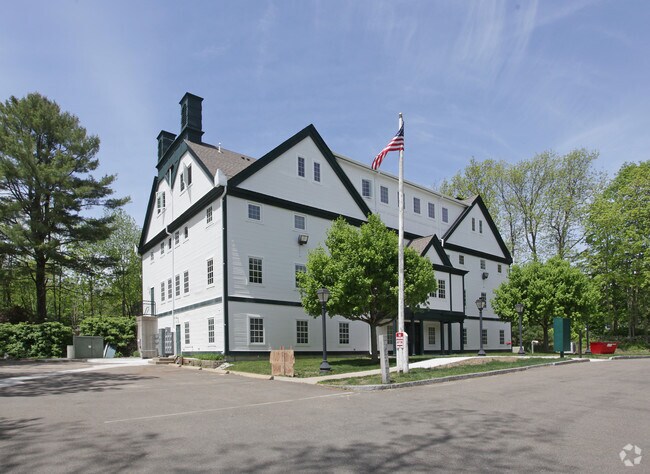
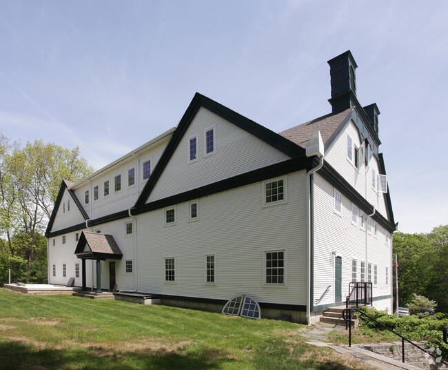
257 Route 80
Officebuilding
Lower Ct River Vly
CD
Connecticut
B and X Area of moderate flood hazard, usually the area between the limits of the 100-year and 500-year floods.
1.52 AC
2025
SW Midlsx/Old Saybrk/Rt 9
2025
Hartford
640100
Hartford-West Hartford-East Hartford, CT
19,219 SF
KILL-000028-000000-000033A
NEARBY LISTINGS FOR SALE OR LEASE
-
-
View all Killingworth listings for sale on LoopNet.com
DEMOGRAPHICS near 257 Route 80
1 mile
3 mile
5 mile
2025 Total Population
816
6,578
24,302
2030 Population
828
6,677
24,598
Pop Growth 2025-2030
+ 1.47%
+ 1.51%
+ 1.22%
Average Age
47
47
45
2025 Total Households
325
2,616
9,264
HH Growth 2025-2030
+ 1.54%
+ 1.53%
+ 1.19%
Median Household Inc
$125,305
$131,122
$140,018
Avg Household Size
2.50
2.50
2.60
2025 Avg HH Vehicles
2.00
2.00
2.00
Median Home Value
$429,592
$458,876
$465,144
Median Year Built
1978
1980
1979
Nearby Places
Map Layers
Map Styles
 Street
 Aerial
Layers
 Traffic
 Biking
Places
Listings with unknown addresses are not visible on the map
- Restaurants
- Banks
- Shops
- Fitness
- Groceries
PUBLIC TRANSPORTATION
COMMUTER RAIL
Drive
Walk
Distance
13 min
6.5 mi
Madison (Shore Line East - Shore Line East)
Drive
Walk
Distance
Madison (Shore Line East - Shore Line East)
17 min
6.8 mi
AIRPORT
Tweed/New Haven
Drive
Walk
Distance
Tweed/New Haven
39 min
22.2 mi
Freight Ports
Port of New Haven
Drive
Walk
Distance
Port of New Haven
36 min
21.0 mi
Nearby Properties
Address
Land Use
TOTAL SIZE
Lot Size
Zoning
Address
Land Use
TOTAL SIZE
Lot Size
Zoning
26.29 AC
R-2
Address
Land Use
TOTAL SIZE
Lot Size
Zoning
384 AC
R-2
Address
Land Use
TOTAL SIZE
Lot Size
Zoning
345 AC
R-2
Address
Land Use
TOTAL SIZE
Lot Size
Zoning
1,224 SF
599.16 AC
RU-1
Address
Land Use
TOTAL SIZE
Lot Size
Zoning
60.97 AC
R-10
Address
Land Use
TOTAL SIZE
Lot Size
Zoning
3,479 SF
255.50 AC
R-2
Address
Land Use
TOTAL SIZE
Lot Size
Zoning
595.01 AC
R-2
Address
Land Use
TOTAL SIZE
Lot Size
Zoning
3.84 AC
CD
Address
Land Use
TOTAL SIZE
Lot Size
Zoning
42.50 AC
R-2
Address
Land Use
TOTAL SIZE
Lot Size
Zoning
26,148 SF
12.22 AC
R-2
Address
Land Use
TOTAL SIZE
Lot Size
Zoning
5.60 AC
R-2
Address
Land Use
TOTAL SIZE
Lot Size
Zoning
9,030 SF
15.60 AC
R-2
Address
Land Use
TOTAL SIZE
Lot Size
Zoning
5.60 AC
CD
Address
Land Use
TOTAL SIZE
Lot Size
Zoning
7,144 SF
2 AC
R-2
Address
Land Use
TOTAL SIZE
Lot Size
Zoning
125.40 AC
R-2
Address
Land Use
TOTAL SIZE
Lot Size
Zoning
20,603 SF
2.73 AC
CD
Address
Land Use
TOTAL SIZE
Lot Size
Zoning
77.06 AC
RU-1
Address
Land Use
TOTAL SIZE
Lot Size
Zoning
5.03 AC
R-2
Address
Land Use
TOTAL SIZE
Lot Size
Zoning
379.10 AC
R-2
Address
Land Use
TOTAL SIZE
Lot Size
Zoning
15.90 AC
R-2
Address
Land Use
TOTAL SIZE
Lot Size
Zoning
1,596 SF
43.40 AC
R-2
Address
Land Use
TOTAL SIZE
Lot Size
Zoning
3.20 AC
CD
Address
Land Use
TOTAL SIZE
Lot Size
Zoning
780 SF
6.60 AC
R-2
Address
Land Use
TOTAL SIZE
Lot Size
Zoning
4,429 SF
1.10 AC
CD
Address
Land Use
TOTAL SIZE
Lot Size
Zoning
17,450 SF
1.92 AC
ID
Address
Land Use
TOTAL SIZE
Lot Size
Zoning
1,034 SF
R-2
Address
Land Use
TOTAL SIZE
Lot Size
Zoning
5,191 SF
7.45 AC
CD
Address
Land Use
TOTAL SIZE
Lot Size
Zoning
2 AC
CD
Address
Land Use
TOTAL SIZE
Lot Size
Zoning
4,977 SF
2 AC
CD
The World's #1 Commercial Real Estate Marketplace
Connect with us
© 2026 CoStar Group
The information above has been obtained from sources believed reliable. While we do not doubt its accuracy we have not verified it and make no guarantee, warranty or representation about it. It is your responsibility to independently confirm its accuracy and completeness. Any projections, opinions, assumptions, or estimates used are for example only and do not represent the current or future performance of the property. The value of this transaction to you depends on tax and other factors which should be evaluated by your tax, financial, and legal advisors. You and your advisors should conduct a careful, independent investigation of the property to determine to your satisfaction the suitability of the property for your needs.