Property Record
257 Tapp Cir, Lyman, SC 29365
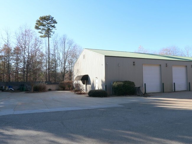

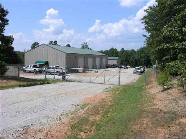
Property Detail
257 Tapp Cir
5-05-00-001.02
PO TR 3 CLEO HENSON ESTATE PB 83-163 PB 139-105 PB 117-980 PB 157-252
Commercialnec
SPARTANBURG
B and X Area of moderate flood hazard, usually the area between the limits of the 100-year and 500-year floods.
South Carolina
2024
7.88 AC
2025
Upper Spartanburg Cty
023201
Greenville/Spartanburg
5,950 SF
Spartanburg, SC
NEARBY LISTINGS FOR SALE OR LEASE
-
-
View all Lyman listings for lease on LoopNet.com
DEMOGRAPHICS near 257 Tapp Cir
1 mile
3 mile
5 mile
2025 Total Population
913
18,457
57,741
2030 Population
1,011
20,463
63,720
Pop Growth 2025-2030
+ 10.73%
+ 10.87%
+ 10.35%
Average Age
41
41
40
2025 Total Households
333
7,030
22,234
HH Growth 2025-2030
+ 10.81%
+ 11.01%
+ 10.45%
Median Household Inc
$83,250
$76,456
$74,438
Avg Household Size
2.50
2.60
2.50
2025 Avg HH Vehicles
2.00
2.00
2.00
Median Home Value
$300,746
$276,214
$279,440
Median Year Built
2001
2000
1998
Nearby Places
Map Layers
Map Styles
 Street
 Aerial
Layers
 Traffic
 Biking
Places
Listings with unknown addresses are not visible on the map
- Restaurants
- Banks
- Shops
- Fitness
- Groceries
PUBLIC TRANSPORTATION
AIRPORT
Greenville Spartanburg International
Drive
Walk
Distance
Greenville Spartanburg International
19 min
10.0 mi
Asheville Regional
Drive
Walk
Distance
Asheville Regional
71 min
48.8 mi
SALE & LEASE HISTORY
LISTING DATE
SALE/LEASE

Dec 05, 2019
For Lease
Nearby Properties
Address
Land Use
TOTAL SIZE
Lot Size
Zoning
Address
Land Use
TOTAL SIZE
Lot Size
Zoning
34.30 AC
UNZONED
Address
Land Use
TOTAL SIZE
Lot Size
Zoning
70.66 AC
RS
Address
Land Use
TOTAL SIZE
Lot Size
Zoning
56.94 AC
Address
Land Use
TOTAL SIZE
Lot Size
Zoning
13,344 SF
125 AC
Address
Land Use
TOTAL SIZE
Lot Size
Zoning
33.77 AC
UNZONED
Address
Land Use
TOTAL SIZE
Lot Size
Zoning
7,002 SF
6.66 AC
Address
Land Use
TOTAL SIZE
Lot Size
Zoning
29.50 AC
UNZONED
Address
Land Use
TOTAL SIZE
Lot Size
Zoning
22.10 AC
RS
Address
Land Use
TOTAL SIZE
Lot Size
Zoning
9,681 SF
2.79 AC
Address
Land Use
TOTAL SIZE
Lot Size
Zoning
11,289 SF
10.30 AC
Address
Land Use
TOTAL SIZE
Lot Size
Zoning
4,216 SF
Address
Land Use
TOTAL SIZE
Lot Size
Zoning
2,164 SF
33.02 AC
Address
Land Use
TOTAL SIZE
Lot Size
Zoning
3,921 SF
5.35 AC
Address
Land Use
TOTAL SIZE
Lot Size
Zoning
4,534 SF
0.56 AC
Address
Land Use
TOTAL SIZE
Lot Size
Zoning
16.60 AC
R12
Address
Land Use
TOTAL SIZE
Lot Size
Zoning
1,998 SF
15.77 AC
RS
Address
Land Use
TOTAL SIZE
Lot Size
Zoning
3,348 SF
1.55 AC
Address
Land Use
TOTAL SIZE
Lot Size
Zoning
3,369 SF
0.57 AC
Address
Land Use
TOTAL SIZE
Lot Size
Zoning
13.97 AC
Address
Land Use
TOTAL SIZE
Lot Size
Zoning
4,599 SF
2.68 AC
Address
Land Use
TOTAL SIZE
Lot Size
Zoning
1,519 SF
9.30 AC
UNZONED
Address
Land Use
TOTAL SIZE
Lot Size
Zoning
4,002 SF
0.47 AC
Address
Land Use
TOTAL SIZE
Lot Size
Zoning
4,381 SF
0.62 AC
Address
Land Use
TOTAL SIZE
Lot Size
Zoning
3,332 SF
2.80 AC
Address
Land Use
TOTAL SIZE
Lot Size
Zoning
3,486 SF
4.31 AC
Address
Land Use
TOTAL SIZE
Lot Size
Zoning
13.20 AC
UNZONED
Address
Land Use
TOTAL SIZE
Lot Size
Zoning
3,018 SF
2.12 AC
Address
Land Use
TOTAL SIZE
Lot Size
Zoning
3,322 SF
0.19 AC
Address
Land Use
TOTAL SIZE
Lot Size
Zoning
2,890 SF
0.54 AC
Address
Land Use
TOTAL SIZE
Lot Size
Zoning
2,642 SF
0.48 AC
The World's #1 Commercial Real Estate Marketplace
Connect with us
© 2026 CoStar Group
The information above has been obtained from sources believed reliable. While we do not doubt its accuracy we have not verified it and make no guarantee, warranty or representation about it. It is your responsibility to independently confirm its accuracy and completeness. Any projections, opinions, assumptions, or estimates used are for example only and do not represent the current or future performance of the property. The value of this transaction to you depends on tax and other factors which should be evaluated by your tax, financial, and legal advisors. You and your advisors should conduct a careful, independent investigation of the property to determine to your satisfaction the suitability of the property for your needs.