Property Record
2570 Ewald Cir, Detroit, MI 48238
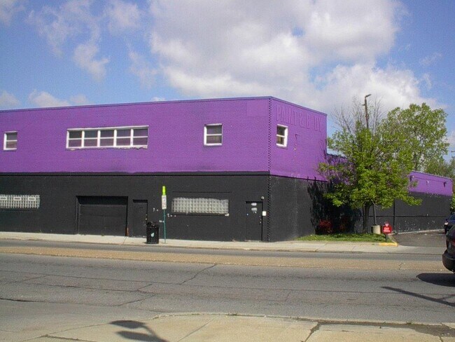


This Property Is For Sale
NEARBY LISTINGS FOR SALE OR LEASE
Property Detail
2570 Ewald Cir
16-0240406
Robert Oakmans Turner & Ford Hwy
Industrialgeneral
N EWALD CIRCLE 8 THRU 14 AMENDED PLAT OF R OAKMANS TURNER & FORD HWY SUB L44 P96 PLATS, W C R 16/313 148 X 110.44
X
Wayne
26163C0100E
Michigan
2025
0.34 AC
2025
Detroit West
536500
Detroit
9,892 SF
Detroit-Warren-Dearborn, MI
DEMOGRAPHICS near 2570 Ewald Cir
1 Mile
3 Mile
5 Mile
2024 Total Population
19,413
164,521
447,849
2029 Population
19,806
166,278
444,041
Pop Growth 2024-2029
+ 2.02%
+ 1.07%
(0.85%)
Average Age
39
39
37
2024 Total Households
8,137
66,473
172,190
HH Growth 2024-2029
+ 2.03%
+ 1.21%
(0.62%)
Median Household Inc
$32,444
$33,734
$37,079
Avg Household Size
2.30
2.40
2.50
2024 Avg HH Vehicles
1.00
1.00
1.00
Median Home Value
$78,539
$83,041
$92,206
Median Year Built
1946
1947
1948
Nearby Places
Map Layers
Map Styles
 Street
 Aerial
- Restaurants
- Banks
- Shops
- Fitness
- Groceries
PUBLIC TRANSPORTATION
COMMUTER RAIL
Detroit (Wolverine - Amtrak)
DRIVE
WALK
Distance
Detroit (Wolverine - Amtrak)
11 min
5.2 mi
AIRPORT
Windsor International
DRIVE
WALK
Distance
Windsor International
33 min
18.0 mi
Detroit Metro Wayne County
DRIVE
WALK
Distance
Detroit Metro Wayne County
35 min
23.8 mi
Freight Ports
Port of Toledo
DRIVE
WALK
Distance
Port of Toledo
80 min
64.6 mi
Nearby Properties
Address
Land Use
TOTAL SIZE
Lot Size
Zoning
Address
Land Use
TOTAL SIZE
Lot Size
Zoning
925,367 SF
12.82 AC
R6
Address
Land Use
TOTAL SIZE
Lot Size
Zoning
783,976 SF
52.57 AC
M4
Address
Land Use
TOTAL SIZE
Lot Size
Zoning
520,522 SF
51.78 AC
M4
Address
Land Use
TOTAL SIZE
Lot Size
Zoning
446,500 SF
27.90 AC
Address
Land Use
TOTAL SIZE
Lot Size
Zoning
165,829 SF
5.56 AC
R5
Address
Land Use
TOTAL SIZE
Lot Size
Zoning
292,032 SF
20.25 AC
B4
Address
Land Use
TOTAL SIZE
Lot Size
Zoning
353,800 SF
15.70 AC
Address
Land Use
TOTAL SIZE
Lot Size
Zoning
54,672 SF
1.37 AC
R6
Address
Land Use
TOTAL SIZE
Lot Size
Zoning
301,000 SF
Address
Land Use
TOTAL SIZE
Lot Size
Zoning
150,689 SF
4.87 AC
R5
Address
Land Use
TOTAL SIZE
Lot Size
Zoning
483,165 SF
22.98 AC
IB
Address
Land Use
TOTAL SIZE
Lot Size
Zoning
500,072 SF
12.50 AC
SD2
Address
Land Use
TOTAL SIZE
Lot Size
Zoning
63,216 SF
2.87 AC
R5
Address
Land Use
TOTAL SIZE
Lot Size
Zoning
66,870 SF
2.77 AC
Address
Land Use
TOTAL SIZE
Lot Size
Zoning
331,590 SF
18.50 AC
M4
Address
Land Use
TOTAL SIZE
Lot Size
Zoning
2,216,908 SF
44.80 AC
Address
Land Use
TOTAL SIZE
Lot Size
Zoning
315,973 SF
12.18 AC
M4
Address
Land Use
TOTAL SIZE
Lot Size
Zoning
110,000 SF
1.36 AC
Address
Land Use
TOTAL SIZE
Lot Size
Zoning
64,566 SF
3.64 AC
PD
Address
Land Use
TOTAL SIZE
Lot Size
Zoning
7.10 AC
Address
Land Use
TOTAL SIZE
Lot Size
Zoning
91,233 SF
11.36 AC
Address
Land Use
TOTAL SIZE
Lot Size
Zoning
Address
Land Use
TOTAL SIZE
Lot Size
Zoning
155,532 SF
1.72 AC
Address
Land Use
TOTAL SIZE
Lot Size
Zoning
74,029 SF
6.44 AC
B3
Address
Land Use
TOTAL SIZE
Lot Size
Zoning
68,729 SF
0.52 AC
B4
Address
Land Use
TOTAL SIZE
Lot Size
Zoning
44,442 SF
3.15 AC
PD
Address
Land Use
TOTAL SIZE
Lot Size
Zoning
46,292 SF
2.76 AC
R1
Address
Land Use
TOTAL SIZE
Lot Size
Zoning
87,232 SF
53.99 AC
R1
Address
Land Use
TOTAL SIZE
Lot Size
Zoning
122,319 SF
M4
Address
Land Use
TOTAL SIZE
Lot Size
Zoning
51,999 SF
1.14 AC
B4
The World's #1 Commercial Real Estate Marketplace
Connect with us
© 2026 CoStar Group
The information above has been obtained from sources believed reliable. While we do not doubt its accuracy we have not verified it and make no guarantee, warranty or representation about it. It is your responsibility to independently confirm its accuracy and completeness. Any projections, opinions, assumptions, or estimates used are for example only and do not represent the current or future performance of the property. The value of this transaction to you depends on tax and other factors which should be evaluated by your tax, financial, and legal advisors. You and your advisors should conduct a careful, independent investigation of the property to determine to your satisfaction the suitability of the property for your needs.