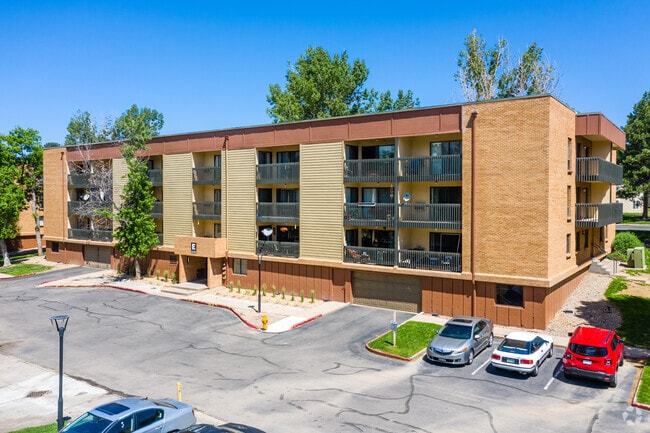
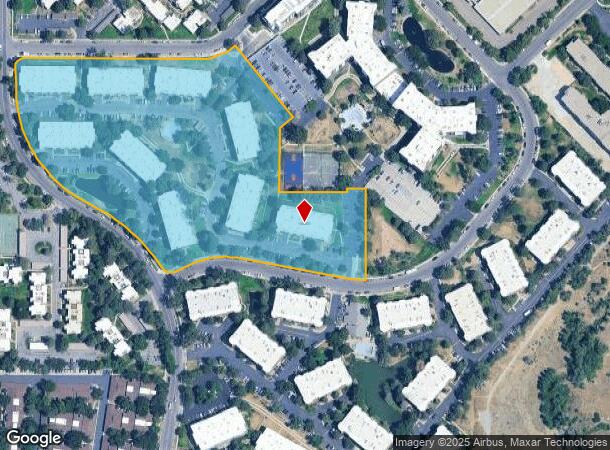
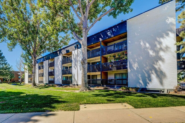
Property Record
2570 S Dayton Way, Denver, CO 80231

NEARBY LISTINGS FOR SALE OR LEASE
Property Detail
2570 S Dayton Way
6274-00-030
Woodstream Village
Apartment
PORTION OF BLOCK 3
X
Denver
0800460236H
Colorado
2024
10.50 AC
2024
Hampden
006813
Denver
268,197 SF
Denver-Aurora-Lakewood, CO
DEMOGRAPHICS near 2570 S Dayton Way
1 Mile
3 Mile
5 Mile
2024 Total Population
18,324
171,367
437,379
2029 Population
18,570
173,376
441,340
Pop Growth 2024-2029
+ 1.34%
+ 1.17%
+ 0.91%
Average Age
40
40
39
2024 Total Households
8,259
78,094
185,868
HH Growth 2024-2029
+ 1.24%
+ 1.11%
+ 0.98%
Median Household Inc
$65,566
$65,067
$71,850
Avg Household Size
2.20
2.10
2.30
2024 Avg HH Vehicles
2.00
2.00
2.00
Median Home Value
$454,539
$427,347
$469,130
Median Year Built
1981
1979
1979
Nearby Places
Map Layers
Map Styles
 Street
 Aerial
- Restaurants
- Banks
- Shops
- Fitness
- Groceries
PUBLIC TRANSPORTATION
COMMUTER RAIL
Peoria Station Track 1 (Union Station to Denver Airport Station - Regional Transportation District)
DRIVE
WALK
Distance
Peoria Station Track 1 (Union Station to Denver Airport Station - Regional Transportation District)
18 min
9.0 mi
Peoria Station Track 2 (Union Station to Denver Airport Station - Regional Transportation District)
DRIVE
WALK
Distance
Peoria Station Track 2 (Union Station to Denver Airport Station - Regional Transportation District)
18 min
9.1 mi
AIRPORT
Denver International
DRIVE
WALK
Distance
Denver International
31 min
23.8 mi
Freight Ports
Tulsa Port Of Catoosa
DRIVE
WALK
Distance
Tulsa Port Of Catoosa
728 min
706.5 mi
Nearby Properties
Address
Land Use
TOTAL SIZE
Lot Size
Zoning
Address
Land Use
TOTAL SIZE
Lot Size
Zoning
163,033 SF
5.94 AC
PUD
Address
Land Use
TOTAL SIZE
Lot Size
Zoning
496,493 SF
33.45 AC
Address
Land Use
TOTAL SIZE
Lot Size
Zoning
898,130 SF
89.50 AC
Address
Land Use
TOTAL SIZE
Lot Size
Zoning
87,207 SF
Address
Land Use
TOTAL SIZE
Lot Size
Zoning
476,186 SF
42.62 AC
Address
Land Use
TOTAL SIZE
Lot Size
Zoning
70,296 SF
4.96 AC
Address
Land Use
TOTAL SIZE
Lot Size
Zoning
372,593 SF
5.61 AC
S-MX-12
Address
Land Use
TOTAL SIZE
Lot Size
Zoning
74,888 SF
4.35 AC
AMU
Address
Land Use
TOTAL SIZE
Lot Size
Zoning
14,878 SF
34.55 AC
OS-B
Address
Land Use
TOTAL SIZE
Lot Size
Zoning
83,951 SF
0.30 AC
R2
Address
Land Use
TOTAL SIZE
Lot Size
Zoning
50,106 SF
1.67 AC
RB1
Address
Land Use
TOTAL SIZE
Lot Size
Zoning
396,041 SF
6.77 AC
B-8
Address
Land Use
TOTAL SIZE
Lot Size
Zoning
231,867 SF
19.33 AC
S-MX-3A
Address
Land Use
TOTAL SIZE
Lot Size
Zoning
613,600 SF
29.40 AC
R-3
Address
Land Use
TOTAL SIZE
Lot Size
Zoning
193,299 SF
2.90 AC
S-MX-12
Address
Land Use
TOTAL SIZE
Lot Size
Zoning
295,877 SF
6 AC
S-MX-12
Address
Land Use
TOTAL SIZE
Lot Size
Zoning
258,612 SF
4.91 AC
B-8
Address
Land Use
TOTAL SIZE
Lot Size
Zoning
328,136 SF
3.56 AC
B-8
Address
Land Use
TOTAL SIZE
Lot Size
Zoning
368,676 SF
17.71 AC
R-2-A
Address
Land Use
TOTAL SIZE
Lot Size
Zoning
341,616 SF
4.88 AC
S-MX-5
Address
Land Use
TOTAL SIZE
Lot Size
Zoning
130,531 SF
3.41 AC
Address
Land Use
TOTAL SIZE
Lot Size
Zoning
283,199 SF
9.74 AC
PUD
Address
Land Use
TOTAL SIZE
Lot Size
Zoning
478,994 SF
26.07 AC
Address
Land Use
TOTAL SIZE
Lot Size
Zoning
48,961 SF
4.15 AC
Address
Land Use
TOTAL SIZE
Lot Size
Zoning
508,135 SF
6.99 AC
C-RX
Address
Land Use
TOTAL SIZE
Lot Size
Zoning
205,250 SF
10 AC
I-A
Address
Land Use
TOTAL SIZE
Lot Size
Zoning
273,952 SF
7.82 AC
C-MU-30
Address
Land Use
TOTAL SIZE
Lot Size
Zoning
154,808 SF
16.71 AC
S-SU-D
Address
Land Use
TOTAL SIZE
Lot Size
Zoning
540,380 SF
26.03 AC
RR3
Address
Land Use
TOTAL SIZE
Lot Size
Zoning
138,750 SF
12.17 AC
OS-A
The World's #1 Commercial Real Estate Marketplace
Connect with us
© 2026 CoStar Group
The information above has been obtained from sources believed reliable. While we do not doubt its accuracy we have not verified it and make no guarantee, warranty or representation about it. It is your responsibility to independently confirm its accuracy and completeness. Any projections, opinions, assumptions, or estimates used are for example only and do not represent the current or future performance of the property. The value of this transaction to you depends on tax and other factors which should be evaluated by your tax, financial, and legal advisors. You and your advisors should conduct a careful, independent investigation of the property to determine to your satisfaction the suitability of the property for your needs.