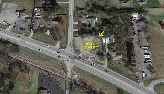
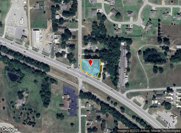
Property Record
25705 E Highway 51, Broken Arrow, OK 74014
NEARBY LISTINGS FOR SALE OR LEASE
Property Detail
25705 E Highway 51
730008006
26-18-15 BEG AT INTER OF NLY R/W OF HWY 51 & ERLY SEC LN RD EASE OF W LN OF SEC 26 -N 116.4' - 61' - SWRLY A DIST OF 141' TO
Privateutilityelectricwatergasnuclearsolarwindetc
Wagoner
X
Oklahoma
40145C0115J
0.78 AC
2024
Wagoner County
2025
Tulsa
030512
Tulsa, OK
864 SF
DEMOGRAPHICS near 25705 E Highway 51
1 Mile
3 Mile
5 Mile
2024 Total Population
1,685
19,244
42,188
2029 Population
1,976
22,564
48,930
Pop Growth 2024-2029
+ 17.27%
+ 17.25%
+ 15.98%
Average Age
39
40
40
2024 Total Households
599
6,889
15,264
HH Growth 2024-2029
+ 17.03%
+ 17.06%
+ 15.83%
Median Household Inc
$91,857
$95,310
$86,447
Avg Household Size
2.70
2.70
2.70
2024 Avg HH Vehicles
3.00
2.00
2.00
Median Home Value
$250,975
$265,203
$248,104
Median Year Built
1999
2002
1999
Nearby Places
Map Layers
Map Styles
 Street
 Aerial
- Restaurants
- Banks
- Shops
- Fitness
- Groceries
PUBLIC TRANSPORTATION
AIRPORT
Tulsa International
DRIVE
WALK
Distance
Tulsa International
31 min
22.5 mi
Freight Ports
DRIVE
WALK
Distance
30 min
21.6 mi
SALE & LEASE HISTORY
LISTING DATE
SALE/LEASE

Jul 20, 2021
For Sale
Nearby Properties
Address
Land Use
TOTAL SIZE
Lot Size
Zoning
Address
Land Use
TOTAL SIZE
Lot Size
Zoning
1,936 SF
4.74 AC
Address
Land Use
TOTAL SIZE
Lot Size
Zoning
6,400 SF
14.96 AC
Address
Land Use
TOTAL SIZE
Lot Size
Zoning
11,220 SF
8.57 AC
Address
Land Use
TOTAL SIZE
Lot Size
Zoning
810 SF
56.23 AC
Address
Land Use
TOTAL SIZE
Lot Size
Zoning
1,080 SF
19.80 AC
Address
Land Use
TOTAL SIZE
Lot Size
Zoning
5,640 SF
1.20 AC
Address
Land Use
TOTAL SIZE
Lot Size
Zoning
2,000 SF
1.55 AC
Address
Land Use
TOTAL SIZE
Lot Size
Zoning
10,000 SF
3 AC
Address
Land Use
TOTAL SIZE
Lot Size
Zoning
9,250 SF
7.46 AC
Address
Land Use
TOTAL SIZE
Lot Size
Zoning
2,520 SF
132.56 AC
Address
Land Use
TOTAL SIZE
Lot Size
Zoning
154 SF
1.36 AC
Address
Land Use
TOTAL SIZE
Lot Size
Zoning
8,000 SF
6.94 AC
Address
Land Use
TOTAL SIZE
Lot Size
Zoning
18,120 SF
2 AC
Address
Land Use
TOTAL SIZE
Lot Size
Zoning
23,865 SF
2.50 AC
Address
Land Use
TOTAL SIZE
Lot Size
Zoning
6,336 SF
3.21 AC
Address
Land Use
TOTAL SIZE
Lot Size
Zoning
168 SF
17.77 AC
Address
Land Use
TOTAL SIZE
Lot Size
Zoning
27,966 SF
4.66 AC
Address
Land Use
TOTAL SIZE
Lot Size
Zoning
Address
Land Use
TOTAL SIZE
Lot Size
Zoning
12,155 SF
3.97 AC
Address
Land Use
TOTAL SIZE
Lot Size
Zoning
8,000 SF
3.91 AC
Address
Land Use
TOTAL SIZE
Lot Size
Zoning
160 AC
TM
Address
Land Use
TOTAL SIZE
Lot Size
Zoning
9,825 SF
6.50 AC
Address
Land Use
TOTAL SIZE
Lot Size
Zoning
27,300 SF
5.16 AC
Address
Land Use
TOTAL SIZE
Lot Size
Zoning
18,000 SF
2.38 AC
Address
Land Use
TOTAL SIZE
Lot Size
Zoning
12,544 SF
1.41 AC
Address
Land Use
TOTAL SIZE
Lot Size
Zoning
4,962 SF
Address
Land Use
TOTAL SIZE
Lot Size
Zoning
3,600 SF
3.35 AC
The World's #1 Commercial Real Estate Marketplace
Connect with us
© 2026 CoStar Group
The information above has been obtained from sources believed reliable. While we do not doubt its accuracy we have not verified it and make no guarantee, warranty or representation about it. It is your responsibility to independently confirm its accuracy and completeness. Any projections, opinions, assumptions, or estimates used are for example only and do not represent the current or future performance of the property. The value of this transaction to you depends on tax and other factors which should be evaluated by your tax, financial, and legal advisors. You and your advisors should conduct a careful, independent investigation of the property to determine to your satisfaction the suitability of the property for your needs.