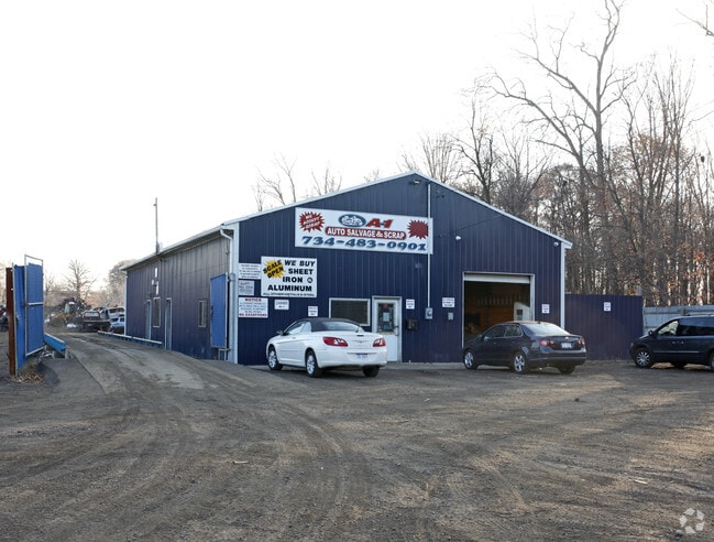
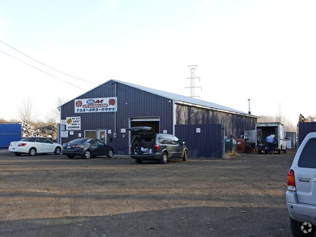
Property Record
2574 State St, Ypsilanti, MI 48198
NEARBY LISTINGS FOR SALE OR LEASE
Property Detail
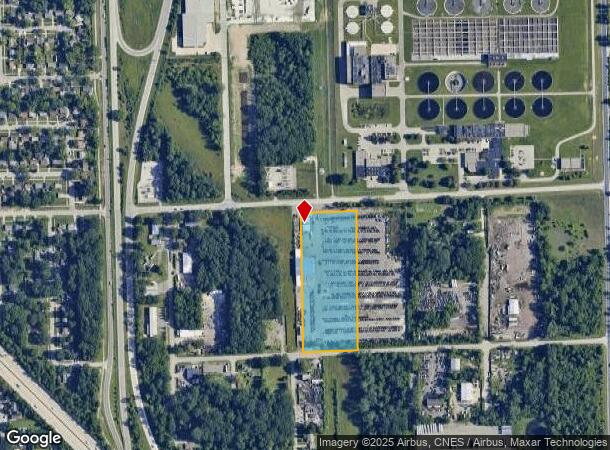
2574 State St
Ann Arbor, MI
Watsonia Park Subdivision
11-13-330-006
LOTS 1443-1449 AND LOTS 1684-1700 WATSONIA PARK SUBDIVISION INCLUDING THE 20 FT VACANT ALLEY BETWEEN LOTS 1443-1449 AND 1700
Commercialnec
Washtenaw
X
Michigan
26161C0435E
2.70 AC
0
Washtenaw E of 23
2025
Detroit
984000
DEMOGRAPHICS near 2574 State St
1 Mile
3 Mile
5 Mile
2024 Total Population
6,610
45,951
112,482
2029 Population
6,563
45,464
110,797
Pop Growth 2024-2029
(0.71%)
(1.06%)
(1.50%)
Average Age
38
39
38
2024 Total Households
2,967
19,773
46,573
HH Growth 2024-2029
(1.08%)
(1.24%)
(1.64%)
Median Household Inc
$53,431
$56,014
$61,242
Avg Household Size
2.10
2.20
2.30
2024 Avg HH Vehicles
2.00
2.00
2.00
Median Home Value
$119,202
$160,405
$205,646
Median Year Built
1969
1972
1977
Nearby Places
Map Layers
Map Styles
 Street
 Aerial
- Restaurants
- Banks
- Shops
- Fitness
- Groceries
PUBLIC TRANSPORTATION
AIRPORT
Detroit Metro Wayne County
DRIVE
WALK
Distance
Detroit Metro Wayne County
20 min
13.7 mi
Freight Ports
Port of Toledo
DRIVE
WALK
Distance
Port of Toledo
69 min
55.3 mi
Nearby Properties
Address
Land Use
TOTAL SIZE
Lot Size
Zoning
Address
Land Use
TOTAL SIZE
Lot Size
Zoning
277.73 AC
Address
Land Use
TOTAL SIZE
Lot Size
Zoning
38,001 SF
177.04 AC
BA
Address
Land Use
TOTAL SIZE
Lot Size
Zoning
11,847 SF
91.35 AC
II
Address
Land Use
TOTAL SIZE
Lot Size
Zoning
97.69 AC
Address
Land Use
TOTAL SIZE
Lot Size
Zoning
26,146 SF
7.35 AC
BI
Address
Land Use
TOTAL SIZE
Lot Size
Zoning
19,692 SF
21.22 AC
BA
Address
Land Use
TOTAL SIZE
Lot Size
Zoning
206,958 SF
8.33 AC
AP
Address
Land Use
TOTAL SIZE
Lot Size
Zoning
198,549 SF
13.43 AC
RM MULT
Address
Land Use
TOTAL SIZE
Lot Size
Zoning
6,192 SF
19.02 AC
BA
Address
Land Use
TOTAL SIZE
Lot Size
Zoning
196,044 SF
18.67 AC
RM MULT
Address
Land Use
TOTAL SIZE
Lot Size
Zoning
59,692 SF
M1 LIG
Address
Land Use
TOTAL SIZE
Lot Size
Zoning
949,540 SF
75.26 AC
M2 GEN
Address
Land Use
TOTAL SIZE
Lot Size
Zoning
48,756 SF
5 AC
CN
Address
Land Use
TOTAL SIZE
Lot Size
Zoning
12,747 SF
17.90 AC
BA
Address
Land Use
TOTAL SIZE
Lot Size
Zoning
1,960 SF
59.97 AC
Address
Land Use
TOTAL SIZE
Lot Size
Zoning
889,111 SF
78.78 AC
Address
Land Use
TOTAL SIZE
Lot Size
Zoning
69,790 SF
6.35 AC
II
Address
Land Use
TOTAL SIZE
Lot Size
Zoning
19,008 SF
9.68 AC
Address
Land Use
TOTAL SIZE
Lot Size
Zoning
76,719 SF
11.69 AC
HHS
Address
Land Use
TOTAL SIZE
Lot Size
Zoning
4,636 SF
18.91 AC
Address
Land Use
TOTAL SIZE
Lot Size
Zoning
161,042 SF
26.29 AC
II
Address
Land Use
TOTAL SIZE
Lot Size
Zoning
28,000 SF
23.30 AC
Address
Land Use
TOTAL SIZE
Lot Size
Zoning
12,747 SF
7.37 AC
BA
Address
Land Use
TOTAL SIZE
Lot Size
Zoning
126,711 SF
12.74 AC
Address
Land Use
TOTAL SIZE
Lot Size
Zoning
12,316 SF
5.51 AC
BA
Address
Land Use
TOTAL SIZE
Lot Size
Zoning
177,366 SF
19.88 AC
II
Address
Land Use
TOTAL SIZE
Lot Size
Zoning
29,610 SF
9.10 AC
BA
Address
Land Use
TOTAL SIZE
Lot Size
Zoning
59,484 SF
4.06 AC
R-4
Address
Land Use
TOTAL SIZE
Lot Size
Zoning
12,747 SF
6.25 AC
BA
Address
Land Use
TOTAL SIZE
Lot Size
Zoning
134,499 SF
6.20 AC
BA
The World's #1 Commercial Real Estate Marketplace
Connect with us
© 2025 CoStar Group
The information above has been obtained from sources believed reliable. While we do not doubt its accuracy we have not verified it and make no guarantee, warranty or representation about it. It is your responsibility to independently confirm its accuracy and completeness. Any projections, opinions, assumptions, or estimates used are for example only and do not represent the current or future performance of the property. The value of this transaction to you depends on tax and other factors which should be evaluated by your tax, financial, and legal advisors. You and your advisors should conduct a careful, independent investigation of the property to determine to your satisfaction the suitability of the property for your needs.