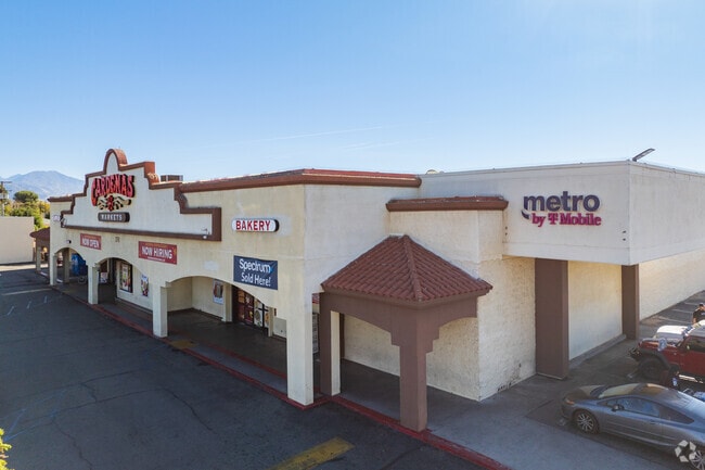
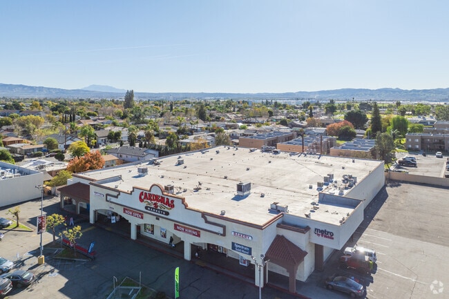
Property Record
25745 Baseline Ave, San Bernardino, CA 92410
NEARBY LISTINGS FOR SALE OR LEASE
Property Detail
25745 Baseline Ave
1192-011-04
Parcel Map No 322
Supermarket
PARCEL MAP NO 322 PAR NO 2 EX PTN COM AT NE COR PAR 1 SD PARCEL MAP 322 TH S 00 DEG O0 MIN 13 SECONDS W ALG E LI SD PAR 1 16.65 FT TH N 89 DEG 58 MIN 49 SECONDS E 0.03 FT TO TRUE POB TH S 00 DEG 00 MIN 33 SECONDS E 183.93 FT TH N 89 DEG 58 MIN 25 SEC
X
San Bernardino
06071C8701J
California
2024
0.74 AC
2025
San Bernardino
007409
Inland Empire (California)
32,388 SF
Riverside-San Bernardino-Ontario, CA
DEMOGRAPHICS near 25745 Baseline Ave
1 Mile
3 Mile
5 Mile
2024 Total Population
25,016
136,163
271,146
2029 Population
25,434
138,650
276,016
Pop Growth 2024-2029
+ 1.67%
+ 1.83%
+ 1.80%
Average Age
32
34
35
2024 Total Households
6,665
38,929
80,495
HH Growth 2024-2029
+ 1.70%
+ 1.92%
+ 1.94%
Median Household Inc
$50,992
$55,201
$60,300
Avg Household Size
3.60
3.30
3.20
2024 Avg HH Vehicles
2.00
2.00
2.00
Median Home Value
$258,867
$327,908
$352,821
Median Year Built
1967
1968
1970
Nearby Places
Map Layers
Map Styles
 Street
 Aerial
- Restaurants
- Banks
- Shops
- Fitness
- Groceries
PUBLIC TRANSPORTATION
COMMUTER RAIL
DRIVE
WALK
Distance
9 min
4.5 mi
DRIVE
WALK
Distance
10 min
4.8 mi
AIRPORT
Ontario International
DRIVE
WALK
Distance
Ontario International
37 min
26.6 mi
SALE & LEASE HISTORY
LISTING DATE
SALE/LEASE

Jan 20, 2021
For Sale
Nearby Properties
Address
Land Use
TOTAL SIZE
Lot Size
Zoning
Address
Land Use
TOTAL SIZE
Lot Size
Zoning
2,134,798 SF
153.92 AC
Address
Land Use
TOTAL SIZE
Lot Size
Zoning
1,079,470 SF
46.39 AC
Address
Land Use
TOTAL SIZE
Lot Size
Zoning
1,079,236 SF
54.70 AC
EVIR
Address
Land Use
TOTAL SIZE
Lot Size
Zoning
708,500 SF
97.74 AC
Address
Land Use
TOTAL SIZE
Lot Size
Zoning
778,653 SF
19.31 AC
Address
Land Use
TOTAL SIZE
Lot Size
Zoning
589,602 SF
36.89 AC
Address
Land Use
TOTAL SIZE
Lot Size
Zoning
1,313,470 SF
60.31 AC
Address
Land Use
TOTAL SIZE
Lot Size
Zoning
497,664 SF
56.39 AC
Address
Land Use
TOTAL SIZE
Lot Size
Zoning
1,139,976 SF
49.56 AC
Address
Land Use
TOTAL SIZE
Lot Size
Zoning
406,710 SF
20.10 AC
Address
Land Use
TOTAL SIZE
Lot Size
Zoning
784,280 SF
34.62 AC
EVSDCOM
Address
Land Use
TOTAL SIZE
Lot Size
Zoning
758,180 SF
31.86 AC
Address
Land Use
TOTAL SIZE
Lot Size
Zoning
809,679 SF
37.19 AC
Address
Land Use
TOTAL SIZE
Lot Size
Zoning
1,205,400 SF
58.05 AC
Address
Land Use
TOTAL SIZE
Lot Size
Zoning
951,686 SF
47.90 AC
Address
Land Use
TOTAL SIZE
Lot Size
Zoning
913,716 SF
20 AC
Address
Land Use
TOTAL SIZE
Lot Size
Zoning
474,680 SF
17.95 AC
Address
Land Use
TOTAL SIZE
Lot Size
Zoning
404,725 SF
19.29 AC
Address
Land Use
TOTAL SIZE
Lot Size
Zoning
472,962 SF
23.28 AC
Address
Land Use
TOTAL SIZE
Lot Size
Zoning
178,926 SF
9.12 AC
IC
Address
Land Use
TOTAL SIZE
Lot Size
Zoning
425,285 SF
24.41 AC
Address
Land Use
TOTAL SIZE
Lot Size
Zoning
699,350 SF
32.11 AC
Address
Land Use
TOTAL SIZE
Lot Size
Zoning
585,064 SF
26.64 AC
EVSDCOM
Address
Land Use
TOTAL SIZE
Lot Size
Zoning
17.69 AC
Address
Land Use
TOTAL SIZE
Lot Size
Zoning
335,000 SF
8.44 AC
Address
Land Use
TOTAL SIZE
Lot Size
Zoning
327,444 SF
15.37 AC
Address
Land Use
TOTAL SIZE
Lot Size
Zoning
415,405 SF
18.43 AC
IC
Address
Land Use
TOTAL SIZE
Lot Size
Zoning
154,639 SF
6.87 AC
Address
Land Use
TOTAL SIZE
Lot Size
Zoning
599,690 SF
17.08 AC
IC
Address
Land Use
TOTAL SIZE
Lot Size
Zoning
413,953 SF
19.58 AC
The World's #1 Commercial Real Estate Marketplace
Connect with us
© 2025 CoStar Group
The information above has been obtained from sources believed reliable. While we do not doubt its accuracy we have not verified it and make no guarantee, warranty or representation about it. It is your responsibility to independently confirm its accuracy and completeness. Any projections, opinions, assumptions, or estimates used are for example only and do not represent the current or future performance of the property. The value of this transaction to you depends on tax and other factors which should be evaluated by your tax, financial, and legal advisors. You and your advisors should conduct a careful, independent investigation of the property to determine to your satisfaction the suitability of the property for your needs.