No Photo
Property Record
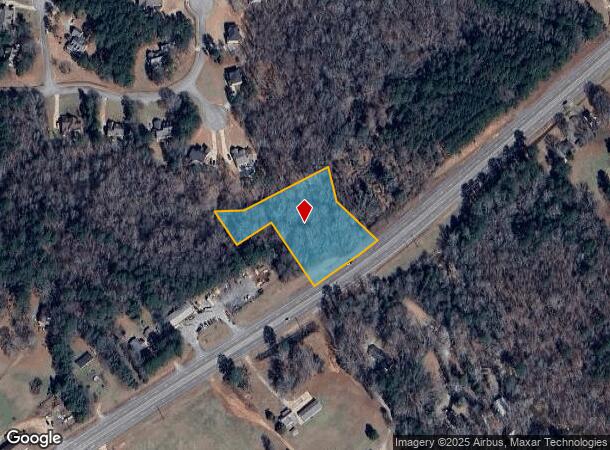
2575 Carver Rd, Griffin, GA 30224
NEARBY LISTINGS FOR SALE OR LEASE
Property Detail
2575 Carver Rd
Atlanta-Sandy Springs-Roswell, GA
Hidden Falls Final
074-081
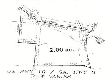
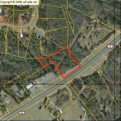
2575 CARVER ROAD OUT TRACT
Residentialacreage
Pike
X
Georgia
13231C0070B
1.42 AC
2024
Pike County
2024
Atlanta
161202
DEMOGRAPHICS near 2575 Carver Rd
1 Mile
3 Mile
5 Mile
2024 Total Population
1,284
10,374
33,296
2029 Population
1,382
11,154
35,724
Pop Growth 2024-2029
+ 7.63%
+ 7.52%
+ 7.29%
Average Age
39
40
39
2024 Total Households
462
3,900
12,542
HH Growth 2024-2029
+ 7.58%
+ 7.28%
+ 7.06%
Median Household Inc
$63,750
$66,616
$58,698
Avg Household Size
2.80
2.60
2.60
2024 Avg HH Vehicles
2.00
2.00
2.00
Median Home Value
$232,039
$209,209
$203,287
Median Year Built
1990
1984
1982
Nearby Places
Map Layers
Map Styles
 Street
 Aerial
- Restaurants
- Banks
- Shops
- Fitness
- Groceries
PUBLIC TRANSPORTATION
AIRPORT
Hartsfield - Jackson Atlanta International
DRIVE
WALK
Distance
Hartsfield - Jackson Atlanta International
54 min
35.5 mi
Nearby Properties
Address
Land Use
TOTAL SIZE
Lot Size
Zoning
Address
Land Use
TOTAL SIZE
Lot Size
Zoning
46,074 SF
30.36 AC
OI
Address
Land Use
TOTAL SIZE
Lot Size
Zoning
99,469 SF
12.51 AC
AR-1
Address
Land Use
TOTAL SIZE
Lot Size
Zoning
2,374 SF
38.28 AC
HDRB
Address
Land Use
TOTAL SIZE
Lot Size
Zoning
31,328 SF
58.43 AC
PID
Address
Land Use
TOTAL SIZE
Lot Size
Zoning
31,328 SF
58.43 AC
PID
Address
Land Use
TOTAL SIZE
Lot Size
Zoning
74,910 SF
25 AC
AR-1
Address
Land Use
TOTAL SIZE
Lot Size
Zoning
43,440 SF
23.20 AC
AR-1
Address
Land Use
TOTAL SIZE
Lot Size
Zoning
3,069 SF
15 AC
HDR-B
Address
Land Use
TOTAL SIZE
Lot Size
Zoning
41,194 SF
25.19 AC
C-1
Address
Land Use
TOTAL SIZE
Lot Size
Zoning
56,516 SF
28.30 AC
C1
Address
Land Use
TOTAL SIZE
Lot Size
Zoning
39,777 SF
10.23 AC
INST
Address
Land Use
TOTAL SIZE
Lot Size
Zoning
5,640 SF
86.60 AC
C2
Address
Land Use
TOTAL SIZE
Lot Size
Zoning
62,250 SF
10.17 AC
Address
Land Use
TOTAL SIZE
Lot Size
Zoning
2,400 SF
5.18 AC
C-1B
Address
Land Use
TOTAL SIZE
Lot Size
Zoning
14,732 SF
1.74 AC
C1
Address
Land Use
TOTAL SIZE
Lot Size
Zoning
46,208 SF
5.79 AC
HDR-B
Address
Land Use
TOTAL SIZE
Lot Size
Zoning
19,600 SF
5.03 AC
PID
Address
Land Use
TOTAL SIZE
Lot Size
Zoning
8,320 SF
0.91 AC
Address
Land Use
TOTAL SIZE
Lot Size
Zoning
22,530 SF
5 AC
PID
Address
Land Use
TOTAL SIZE
Lot Size
Zoning
10,013 SF
3.81 AC
C-1
Address
Land Use
TOTAL SIZE
Lot Size
Zoning
6,732 SF
6.71 AC
Address
Land Use
TOTAL SIZE
Lot Size
Zoning
5,544 SF
8.49 AC
C1
Address
Land Use
TOTAL SIZE
Lot Size
Zoning
48,820 SF
5.27 AC
PID
Address
Land Use
TOTAL SIZE
Lot Size
Zoning
5,640 SF
4.06 AC
RESIDENTIA
Address
Land Use
TOTAL SIZE
Lot Size
Zoning
77,300 SF
21.95 AC
PCD
Address
Land Use
TOTAL SIZE
Lot Size
Zoning
155,918 SF
9.95 AC
PID
Address
Land Use
TOTAL SIZE
Lot Size
Zoning
8,116 SF
2.48 AC
Address
Land Use
TOTAL SIZE
Lot Size
Zoning
51,776 SF
17.21 AC
PID
Address
Land Use
TOTAL SIZE
Lot Size
Zoning
97,810 SF
10.50 AC
COMMERCIAL
Address
Land Use
TOTAL SIZE
Lot Size
Zoning
144.29 AC
INST
The World's #1 Commercial Real Estate Marketplace
Connect with us
© 2025 CoStar Group
The information above has been obtained from sources believed reliable. While we do not doubt its accuracy we have not verified it and make no guarantee, warranty or representation about it. It is your responsibility to independently confirm its accuracy and completeness. Any projections, opinions, assumptions, or estimates used are for example only and do not represent the current or future performance of the property. The value of this transaction to you depends on tax and other factors which should be evaluated by your tax, financial, and legal advisors. You and your advisors should conduct a careful, independent investigation of the property to determine to your satisfaction the suitability of the property for your needs.