Property Record
2575 E 8Th St, National City, CA 91950
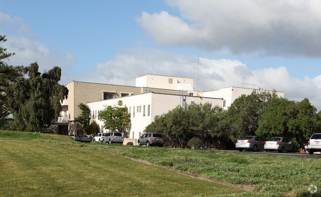

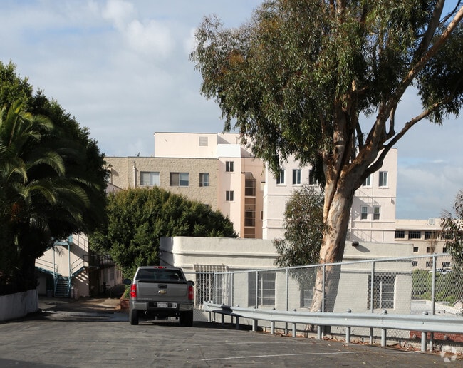

Property Detail
2575 E 8Th St
554-280-06
LOT 6 TR 015657
Hospitalpublic
San Diego
I
California
B and X Area of moderate flood hazard, usually the area between the limits of the 100-year and 500-year floods.
6
2024
7.21 AC
2025
National City
011902
San Diego
76,798 SF
San Diego-Chula Vista-Carlsbad, CA
NEARBY LISTINGS FOR SALE OR LEASE
-
-
View all National City listings for sale on LoopNet.com
DEMOGRAPHICS near 2575 E 8Th St
1 mile
3 mile
5 mile
2025 Total Population
33,956
221,496
522,835
2030 Population
34,014
221,451
523,439
Pop Growth 2025-2030
+ 0.17%
(0.02%)
+ 0.12%
Average Age
39
38
38
2025 Total Households
9,648
62,675
166,449
HH Growth 2025-2030
(0.02%)
(0.15%)
+ 0.12%
Median Household Inc
$76,195
$78,270
$81,424
Avg Household Size
3.40
3.30
3.00
2025 Avg HH Vehicles
2.00
2.00
2.00
Median Home Value
$701,967
$683,737
$722,210
Median Year Built
1968
1970
1970
Nearby Places
Map Layers
Map Styles
 Street
 Aerial
Transit
 Traffic
 Biking
Places
Listings with unknown addresses are not visible on the map
- Restaurants
- Banks
- Shops
- Fitness
- Groceries
PUBLIC TRANSPORTATION
COMMUTER RAIL
San Diego (Santa Fe Depot) (Coaster - San Diego North County Transit District (Coaster/Sprinter/Breeze))
Drive
Walk
Distance
San Diego (Santa Fe Depot) (Coaster - San Diego North County Transit District (Coaster/Sprinter/Breeze))
13 min
7.1 mi
AIRPORT
San Diego International
Drive
Walk
Distance
San Diego International
16 min
9.7 mi
Freight Ports
Port of San Diego
Drive
Walk
Distance
Port of San Diego
11 min
5.6 mi
Nearby Properties
Address
Land Use
TOTAL SIZE
Lot Size
Zoning
Address
Land Use
TOTAL SIZE
Lot Size
Zoning
6.55 AC
MXD-2
Address
Land Use
TOTAL SIZE
Lot Size
Zoning
15.72 AC
RM-2-5
Address
Land Use
TOTAL SIZE
Lot Size
Zoning
12.19 AC
RM-2
Address
Land Use
TOTAL SIZE
Lot Size
Zoning
8.99 AC
IL-2-1
Address
Land Use
TOTAL SIZE
Lot Size
Zoning
10.92 AC
RM-2-5
Address
Land Use
TOTAL SIZE
Lot Size
Zoning
9.62 AC
MXD-2
Address
Land Use
TOTAL SIZE
Lot Size
Zoning
10.43 AC
RM-2
Address
Land Use
TOTAL SIZE
Lot Size
Zoning
9.84 AC
C
Address
Land Use
TOTAL SIZE
Lot Size
Zoning
24.06 AC
R3
Address
Land Use
TOTAL SIZE
Lot Size
Zoning
7.52 AC
MCR-2
Address
Land Use
TOTAL SIZE
Lot Size
Zoning
6.85 AC
IL
Address
Land Use
TOTAL SIZE
Lot Size
Zoning
6.07 AC
MXD-1
Address
Land Use
TOTAL SIZE
Lot Size
Zoning
4.80 AC
MXD-2
Address
Land Use
TOTAL SIZE
Lot Size
Zoning
Address
Land Use
TOTAL SIZE
Lot Size
Zoning
4.12 AC
RM-2-5
Address
Land Use
TOTAL SIZE
Lot Size
Zoning
Address
Land Use
TOTAL SIZE
Lot Size
Zoning
0.68 AC
MXU
Address
Land Use
TOTAL SIZE
Lot Size
Zoning
3,274 SF
8.58 AC
RM-2-5
Address
Land Use
TOTAL SIZE
Lot Size
Zoning
86,920 SF
2.38 AC
RM-2
Address
Land Use
TOTAL SIZE
Lot Size
Zoning
2.24 AC
MXD-2
Address
Land Use
TOTAL SIZE
Lot Size
Zoning
0.89 AC
MXU
Address
Land Use
TOTAL SIZE
Lot Size
Zoning
4.42 AC
MM
Address
Land Use
TOTAL SIZE
Lot Size
Zoning
13.87 AC
MXD-2
Address
Land Use
TOTAL SIZE
Lot Size
Zoning
91,326 SF
2.42 AC
CCP
Address
Land Use
TOTAL SIZE
Lot Size
Zoning
32,670 SF
0.75 AC
V-1
Address
Land Use
TOTAL SIZE
Lot Size
Zoning
9,764 SF
20.67 AC
Marine Ter
Address
Land Use
TOTAL SIZE
Lot Size
Zoning
Address
Land Use
TOTAL SIZE
Lot Size
Zoning
69,408 SF
2.26 AC
R3D
Address
Land Use
TOTAL SIZE
Lot Size
Zoning
3.52 AC
MXD-2
The World's #1 Commercial Real Estate Marketplace
Connect with us
© 2026 CoStar Group
The information above has been obtained from sources believed reliable. While we do not doubt its accuracy we have not verified it and make no guarantee, warranty or representation about it. It is your responsibility to independently confirm its accuracy and completeness. Any projections, opinions, assumptions, or estimates used are for example only and do not represent the current or future performance of the property. The value of this transaction to you depends on tax and other factors which should be evaluated by your tax, financial, and legal advisors. You and your advisors should conduct a careful, independent investigation of the property to determine to your satisfaction the suitability of the property for your needs.