Property Record
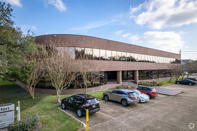
2575 W Bellfort Ave, Houston, TX 77054

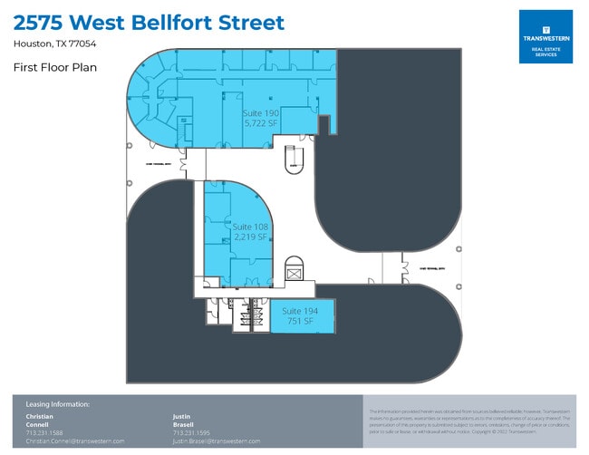

Current Lease Availabilities
Property Detail
2575 W Bellfort Ave
1152090000004
RES D LAKES AT 610 SEC 1
Medicalbuilding
HARRIS
B and X Area of moderate flood hazard, usually the area between the limits of the 100-year and 500-year floods.
Texas
2024
2.90 AC
2025
South Main/Medical Center
334101
Houston
55,106 SF
Houston-Pasadena-The Woodlands, TX
NEARBY LISTINGS FOR SALE OR LEASE
DEMOGRAPHICS near 2575 W Bellfort Ave
1 mile
3 mile
5 mile
2025 Total Population
13,143
127,543
426,996
2030 Population
14,121
137,585
459,073
Pop Growth 2025-2030
+ 7.44%
+ 7.87%
+ 7.51%
Average Age
36
37
38
2025 Total Households
6,982
56,700
178,160
HH Growth 2025-2030
+ 7.53%
+ 8.20%
+ 7.86%
Median Household Inc
$59,198
$72,420
$72,332
Avg Household Size
1.90
2.20
2.30
2025 Avg HH Vehicles
1.00
1.00
2.00
Median Home Value
$299,075
$435,240
$369,711
Median Year Built
1994
1991
1986
Nearby Places
Map Layers
Map Styles
 Street
 Aerial
Layers
 Traffic
 Biking
Places
Listings with unknown addresses are not visible on the map
- Restaurants
- Banks
- Shops
- Fitness
- Groceries
PUBLIC TRANSPORTATION
TRANSIT/SUBWAY
Fannin South Stn Sb (METRORAIL RED LINE - Metropolitan Transit Authority of Harris County)
Drive
Walk
Distance
Fannin South Stn Sb (METRORAIL RED LINE - Metropolitan Transit Authority of Harris County)
2 min
20 min
1.1 mi
COMMUTER RAIL
Houston (Sunset Limited - Amtrak)
Drive
Walk
Distance
Houston (Sunset Limited - Amtrak)
16 min
9.7 mi
AIRPORT
William P Hobby
Drive
Walk
Distance
William P Hobby
24 min
13.0 mi
George Bush Intcntl/Houston
Drive
Walk
Distance
George Bush Intcntl/Houston
37 min
27.0 mi
Freight Ports
Port of Houston
Drive
Walk
Distance
Port of Houston
21 min
13.3 mi
Nearby Properties
Address
Land Use
TOTAL SIZE
Lot Size
Zoning
Address
Land Use
TOTAL SIZE
Lot Size
Zoning
519,409 SF
1.52 AC
Address
Land Use
TOTAL SIZE
Lot Size
Zoning
704,249 SF
2.34 AC
Address
Land Use
TOTAL SIZE
Lot Size
Zoning
1,359,194 SF
Address
Land Use
TOTAL SIZE
Lot Size
Zoning
402,467 SF
28.30 AC
Address
Land Use
TOTAL SIZE
Lot Size
Zoning
1,009,859 SF
28.73 AC
Address
Land Use
TOTAL SIZE
Lot Size
Zoning
777,791 SF
47.90 AC
Address
Land Use
TOTAL SIZE
Lot Size
Zoning
507,499 SF
7.66 AC
Address
Land Use
TOTAL SIZE
Lot Size
Zoning
444,589 SF
11 AC
Address
Land Use
TOTAL SIZE
Lot Size
Zoning
577,327 SF
28.80 AC
Address
Land Use
TOTAL SIZE
Lot Size
Zoning
828,746 SF
7.76 AC
Address
Land Use
TOTAL SIZE
Lot Size
Zoning
396,888 SF
2.02 AC
Address
Land Use
TOTAL SIZE
Lot Size
Zoning
15.46 AC
Address
Land Use
TOTAL SIZE
Lot Size
Zoning
499,411 SF
5.73 AC
Address
Land Use
TOTAL SIZE
Lot Size
Zoning
1,000,928 SF
18.79 AC
Address
Land Use
TOTAL SIZE
Lot Size
Zoning
550,115 SF
6.38 AC
Address
Land Use
TOTAL SIZE
Lot Size
Zoning
562,131 SF
4.11 AC
Address
Land Use
TOTAL SIZE
Lot Size
Zoning
353,738 SF
2.04 AC
Address
Land Use
TOTAL SIZE
Lot Size
Zoning
651,551 SF
52.18 AC
Address
Land Use
TOTAL SIZE
Lot Size
Zoning
284,836 SF
4.22 AC
Address
Land Use
TOTAL SIZE
Lot Size
Zoning
335,626 SF
4.22 AC
Address
Land Use
TOTAL SIZE
Lot Size
Zoning
507,395 SF
9.22 AC
Address
Land Use
TOTAL SIZE
Lot Size
Zoning
499,978 SF
5.57 AC
Address
Land Use
TOTAL SIZE
Lot Size
Zoning
643,698 SF
6.57 AC
Address
Land Use
TOTAL SIZE
Lot Size
Zoning
354,377 SF
8.10 AC
Address
Land Use
TOTAL SIZE
Lot Size
Zoning
410,109 SF
0.69 AC
Address
Land Use
TOTAL SIZE
Lot Size
Zoning
365,485 SF
13.94 AC
Address
Land Use
TOTAL SIZE
Lot Size
Zoning
397,924 SF
3.64 AC
Address
Land Use
TOTAL SIZE
Lot Size
Zoning
380,761 SF
0.92 AC
Address
Land Use
TOTAL SIZE
Lot Size
Zoning
257,963 SF
6.39 AC
Address
Land Use
TOTAL SIZE
Lot Size
Zoning
518,025 SF
18.09 AC
The World's #1 Commercial Real Estate Marketplace
Connect with us
© 2026 CoStar Group
The information above has been obtained from sources believed reliable. While we do not doubt its accuracy we have not verified it and make no guarantee, warranty or representation about it. It is your responsibility to independently confirm its accuracy and completeness. Any projections, opinions, assumptions, or estimates used are for example only and do not represent the current or future performance of the property. The value of this transaction to you depends on tax and other factors which should be evaluated by your tax, financial, and legal advisors. You and your advisors should conduct a careful, independent investigation of the property to determine to your satisfaction the suitability of the property for your needs.