Property Record
2580 Route 302, Middletown, NY 10941
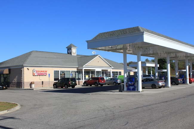

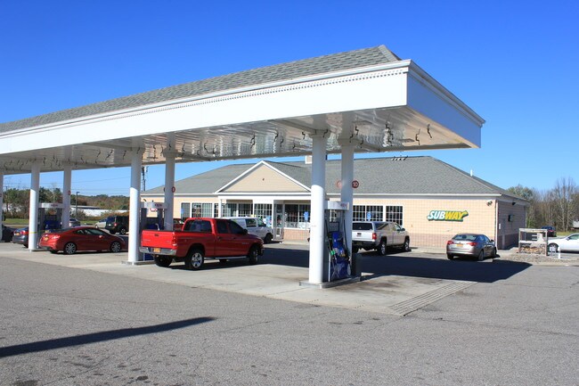
Property Detail
2580 Route 302
335200-022-000-0003-054.100-0000
Orange
Supermarket
New York
ENT-L
54.10
B and X Area of moderate flood hazard, usually the area between the limits of the 100-year and 500-year floods.
2.80 AC
2024
Middletown
2024
Northern New Jersey
011000
Kiryas Joel-Poughkeepsie-Newburgh, NY
5,400 SF
NEARBY LISTINGS FOR SALE OR LEASE
DEMOGRAPHICS near 2580 Route 302
1 mile
3 mile
5 mile
2025 Total Population
763
26,258
63,884
2030 Population
794
26,704
65,032
Pop Growth 2025-2030
+ 4.06%
+ 1.70%
+ 1.80%
Average Age
42
41
39
2025 Total Households
275
9,646
23,164
HH Growth 2025-2030
+ 4.36%
+ 1.74%
+ 1.90%
Median Household Inc
$103,323
$90,006
$88,690
Avg Household Size
2.70
2.60
2.60
2025 Avg HH Vehicles
2.00
2.00
2.00
Median Home Value
$440,579
$360,571
$341,734
Median Year Built
1985
1976
1974
Nearby Places
Map Layers
Map Styles
 Street
 Aerial
Transit
 Traffic
 Biking
Places
Listings with unknown addresses are not visible on the map
- Restaurants
- Banks
- Shops
- Fitness
- Groceries
PUBLIC TRANSPORTATION
COMMUTER RAIL
Middletown New York (Bergen County/Port Jervis Line - NJ Transit Commuter Rail (NJ Transit), Main/Port Jervis Line - NJ Transit Commuter Rail (NJ Transit))
Drive
Walk
Distance
Middletown New York (Bergen County/Port Jervis Line - NJ Transit Commuter Rail (NJ Transit), Main/Port Jervis Line - NJ Transit Commuter Rail (NJ Transit))
9 min
4.0 mi
AIRPORT
New York Stewart International
Drive
Walk
Distance
New York Stewart International
30 min
21.7 mi
SALE & LEASE HISTORY
LISTING DATE
SALE/LEASE

Sep 24, 2019
For Sale
Sep 12, 2018
For Sale
Sep 05, 2018
For Sale
Nov 11, 2020
For Sale
Mar 15, 2019
For Sale
Jan 15, 2020
For Sale
Dec 11, 2017
For Sale
Nearby Properties
Address
Land Use
TOTAL SIZE
Lot Size
Zoning
Address
Land Use
TOTAL SIZE
Lot Size
Zoning
35.70 AC
R2
Address
Land Use
TOTAL SIZE
Lot Size
Zoning
24.40 AC
R-1
Address
Land Use
TOTAL SIZE
Lot Size
Zoning
58.10 AC
R1
Address
Land Use
TOTAL SIZE
Lot Size
Zoning
289,910 SF
19.90 AC
TC
Address
Land Use
TOTAL SIZE
Lot Size
Zoning
5,753 SF
18 AC
TC
Address
Land Use
TOTAL SIZE
Lot Size
Zoning
20.90 AC
Address
Land Use
TOTAL SIZE
Lot Size
Zoning
208,464 SF
24.90 AC
HC
Address
Land Use
TOTAL SIZE
Lot Size
Zoning
96,231 SF
14.80 AC
HC
Address
Land Use
TOTAL SIZE
Lot Size
Zoning
71,031 SF
7.30 AC
TC
Address
Land Use
TOTAL SIZE
Lot Size
Zoning
87,090 SF
4.50 AC
TC
Address
Land Use
TOTAL SIZE
Lot Size
Zoning
59,736 SF
6.10 AC
TC
Address
Land Use
TOTAL SIZE
Lot Size
Zoning
91,794 SF
7.70 AC
R1
Address
Land Use
TOTAL SIZE
Lot Size
Zoning
17,536 SF
5.40 AC
HC
Address
Land Use
TOTAL SIZE
Lot Size
Zoning
4,896 SF
11.90 AC
R2
Address
Land Use
TOTAL SIZE
Lot Size
Zoning
102,676 SF
6.10 AC
TC
Address
Land Use
TOTAL SIZE
Lot Size
Zoning
161,652 SF
16 AC
TC
Address
Land Use
TOTAL SIZE
Lot Size
Zoning
85,895 SF
31.80 AC
R1
Address
Land Use
TOTAL SIZE
Lot Size
Zoning
161,896 SF
10.40 AC
ENT-L
Address
Land Use
TOTAL SIZE
Lot Size
Zoning
160,336 SF
12.10 AC
R1
Address
Land Use
TOTAL SIZE
Lot Size
Zoning
Address
Land Use
TOTAL SIZE
Lot Size
Zoning
125,144 SF
6.60 AC
Address
Land Use
TOTAL SIZE
Lot Size
Zoning
48,587 SF
8.50 AC
R1
Address
Land Use
TOTAL SIZE
Lot Size
Zoning
68,963 SF
2 AC
TC
Address
Land Use
TOTAL SIZE
Lot Size
Zoning
55,722 SF
7.70 AC
TC
Address
Land Use
TOTAL SIZE
Lot Size
Zoning
7.50 AC
HC
Address
Land Use
TOTAL SIZE
Lot Size
Zoning
87,210 SF
5.20 AC
ENT-L
Address
Land Use
TOTAL SIZE
Lot Size
Zoning
50,232 SF
6.20 AC
R1
Address
Land Use
TOTAL SIZE
Lot Size
Zoning
71,338 SF
5.30 AC
ENT-L
Address
Land Use
TOTAL SIZE
Lot Size
Zoning
90,079 SF
4.70 AC
R1
Address
Land Use
TOTAL SIZE
Lot Size
Zoning
198,965 SF
15.90 AC
HC
The World's #1 Commercial Real Estate Marketplace
Connect with us
© 2026 CoStar Group
The information above has been obtained from sources believed reliable. While we do not doubt its accuracy we have not verified it and make no guarantee, warranty or representation about it. It is your responsibility to independently confirm its accuracy and completeness. Any projections, opinions, assumptions, or estimates used are for example only and do not represent the current or future performance of the property. The value of this transaction to you depends on tax and other factors which should be evaluated by your tax, financial, and legal advisors. You and your advisors should conduct a careful, independent investigation of the property to determine to your satisfaction the suitability of the property for your needs.