Property Record
25807 State Highway 189, Twin Peaks, CA 92391
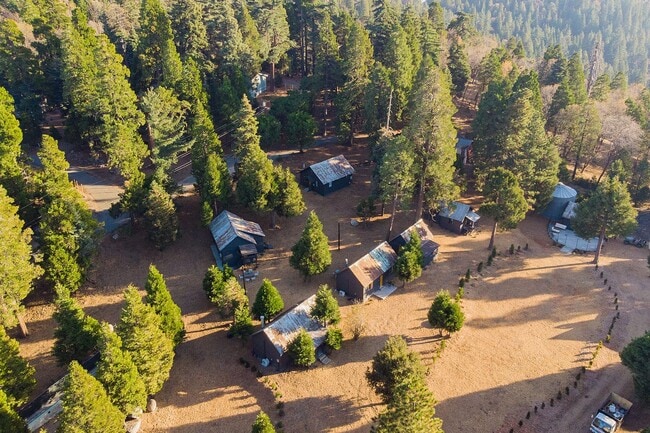
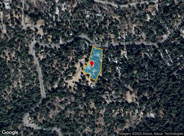
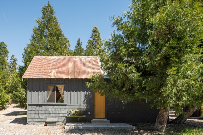
This Property Is For Sale
NEARBY LISTINGS FOR SALE OR LEASE
Property Detail
25807 State Highway 189
Riverside-San Bernardino-Ontario, CA
Tract 7909
0336-211-20
ALL OF LOTS 110 & 111 INCLUDING A PORTION OF LOT 112, TRACT 7909, AS RECORDED IN BOOK 104, PAGES 22 THROUGH 27, INCLUSIVE, OF MAPS, AS RECORDED IN THE COUNTY OF SAN BERNARDINO, STATE OF CALIFORNIA. SAID LEGAL DESCRIPTION IS MORE PARTICULARLY DESCRIBE
Quadruplex
San Bernardino
D
California
06071C7955H
110
2024
1.03 AC
2025
San Bernardino Surrounding
011004
Inland Empire (California)
3,186 SF
DEMOGRAPHICS near 25807 State Highway 189
1 Mile
3 Mile
5 Mile
2024 Total Population
2,131
11,652
23,050
2029 Population
2,034
11,246
22,532
Pop Growth 2024-2029
(4.55%)
(3.48%)
(2.25%)
Average Age
42
44
43
2024 Total Households
851
4,777
9,156
HH Growth 2024-2029
(4.70%)
(3.60%)
(2.47%)
Median Household Inc
$76,154
$86,630
$86,080
Avg Household Size
2.40
2.30
2.40
2024 Avg HH Vehicles
2.00
2.00
2.00
Median Home Value
$472,499
$483,673
$487,961
Median Year Built
1969
1970
1970
Nearby Places
- Restaurants
- Banks
- Shops
- Fitness
- Groceries
PUBLIC TRANSPORTATION
AIRPORT
Ontario International
DRIVE
WALK
Distance
Ontario International
53 min
38.0 mi
Freight Ports
Port of Long Beach
DRIVE
WALK
Distance
Port of Long Beach
110 min
86.0 mi
Nearby Properties
Address
Land Use
TOTAL SIZE
Lot Size
Zoning
Address
Land Use
TOTAL SIZE
Lot Size
Zoning
73,307 SF
32.90 AC
CFSDRES
Address
Land Use
TOTAL SIZE
Lot Size
Zoning
160,928 SF
8.77 AC
LACG
Address
Land Use
TOTAL SIZE
Lot Size
Zoning
25.95 AC
CFSDRES
Address
Land Use
TOTAL SIZE
Lot Size
Zoning
79,205 SF
17.72 AC
Address
Land Use
TOTAL SIZE
Lot Size
Zoning
78,044 SF
3.18 AC
LACS
Address
Land Use
TOTAL SIZE
Lot Size
Zoning
38,415 SF
33.85 AC
CFRS14M
Address
Land Use
TOTAL SIZE
Lot Size
Zoning
43,673 SF
2.63 AC
Address
Land Use
TOTAL SIZE
Lot Size
Zoning
32,675 SF
91.96 AC
LARC
Address
Land Use
TOTAL SIZE
Lot Size
Zoning
13,816 SF
28.10 AC
Address
Land Use
TOTAL SIZE
Lot Size
Zoning
32,648 SF
1.44 AC
LACGSCP
Address
Land Use
TOTAL SIZE
Lot Size
Zoning
172.99 AC
Address
Land Use
TOTAL SIZE
Lot Size
Zoning
46,398 SF
1.88 AC
CFCGSCP
Address
Land Use
TOTAL SIZE
Lot Size
Zoning
Address
Land Use
TOTAL SIZE
Lot Size
Zoning
22,887 SF
19.30 AC
LARS14M
Address
Land Use
TOTAL SIZE
Lot Size
Zoning
22,542 SF
7.03 AC
LARS14M
Address
Land Use
TOTAL SIZE
Lot Size
Zoning
25,759 SF
0.98 AC
LACGSCP
Address
Land Use
TOTAL SIZE
Lot Size
Zoning
3,570 SF
0.86 AC
LACS
Address
Land Use
TOTAL SIZE
Lot Size
Zoning
31,164 SF
0.82 AC
LACGSCP
Address
Land Use
TOTAL SIZE
Lot Size
Zoning
15,462 SF
0.52 AC
LACGSCP
Address
Land Use
TOTAL SIZE
Lot Size
Zoning
Address
Land Use
TOTAL SIZE
Lot Size
Zoning
3.45 AC
LACGSCP
Address
Land Use
TOTAL SIZE
Lot Size
Zoning
9,523 SF
0.67 AC
C
Address
Land Use
TOTAL SIZE
Lot Size
Zoning
2,784 SF
0.70 AC
LACN
Address
Land Use
TOTAL SIZE
Lot Size
Zoning
1,922 SF
0.53 AC
CFCGSCP
Address
Land Use
TOTAL SIZE
Lot Size
Zoning
8,501 SF
2.09 AC
LARM
Address
Land Use
TOTAL SIZE
Lot Size
Zoning
4,094 SF
0.18 AC
C1
Address
Land Use
TOTAL SIZE
Lot Size
Zoning
12,368 SF
1.42 AC
LARS14M
Address
Land Use
TOTAL SIZE
Lot Size
Zoning
11,905 SF
3.33 AC
LARS14M
Address
Land Use
TOTAL SIZE
Lot Size
Zoning
10.79 AC
CFRL5
Address
Land Use
TOTAL SIZE
Lot Size
Zoning
2,701 SF
0.63 AC
LACG
The World's #1 Commercial Real Estate Marketplace
Connect with us
© 2025 CoStar Group
The information above has been obtained from sources believed reliable. While we do not doubt its accuracy we have not verified it and make no guarantee, warranty or representation about it. It is your responsibility to independently confirm its accuracy and completeness. Any projections, opinions, assumptions, or estimates used are for example only and do not represent the current or future performance of the property. The value of this transaction to you depends on tax and other factors which should be evaluated by your tax, financial, and legal advisors. You and your advisors should conduct a careful, independent investigation of the property to determine to your satisfaction the suitability of the property for your needs.