Property Record
25809 Us Highway 52, Minooka, IL 60447
Save to a Folder
{{folder.Name}}
{{folder.ListingIds.length}} Properties
{{folder.ListingIds.length}} Property
Create a New Folder
Property Detail
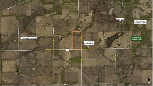
25809 Us Highway 52
Chicago-Naperville-Elgin, IL-IN
SEC. 18-35-8, 82.42 AC IN E 1/2 NE 1/4
09-18-200-004
KENDALL
Farms
Illinois
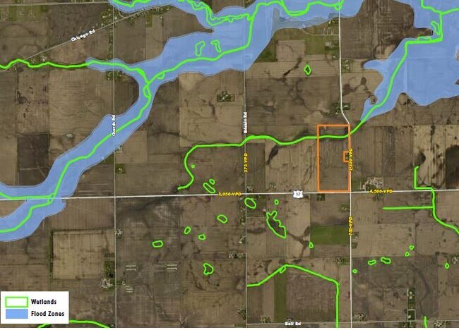
AE The base floodplain where base flood elevations are provided. AE Zones are now used on new format FIRMs instead of A1-A30 Zones.
82.42 AC
2024
Joliet/Central Will
2025
Chicago
890703
NEARBY LISTINGS FOR SALE OR LEASE
-
-
View all Minooka listings for sale on LoopNet.com
DEMOGRAPHICS near 25809 Us Highway 52
1 mile
3 mile
5 mile
2025 Total Population
89
850
12,861
2030 Population
96
908
13,893
Pop Growth 2025-2030
+ 7.87%
+ 6.82%
+ 8.02%
Average Age
35
37
34
2025 Total Households
28
279
3,885
HH Growth 2025-2030
+ 7.14%
+ 6.45%
+ 7.85%
Median Household Inc
$124,999
$122,916
$128,029
Avg Household Size
3.20
3.10
3.30
2025 Avg HH Vehicles
3.00
3.00
3.00
Median Home Value
$309,091
$313,542
$333,141
Median Year Built
2005
2000
2006
Nearby Places
Map Layers
Map Styles
 Street
 Aerial
Layers
 Traffic
 Biking
Places
Listings with unknown addresses are not visible on the map
- Restaurants
- Banks
- Shops
- Fitness
- Groceries
SALE & LEASE HISTORY
LISTING DATE
SALE/LEASE

Oct 27, 2020
For Sale
Nearby Properties
Address
Land Use
TOTAL SIZE
Lot Size
Zoning
Address
Land Use
TOTAL SIZE
Lot Size
Zoning
167.65 AC
Address
Land Use
TOTAL SIZE
Lot Size
Zoning
155.02 AC
Address
Land Use
TOTAL SIZE
Lot Size
Zoning
141.58 AC
Address
Land Use
TOTAL SIZE
Lot Size
Zoning
1.31 AC
Address
Land Use
TOTAL SIZE
Lot Size
Zoning
104.16 AC
Address
Land Use
TOTAL SIZE
Lot Size
Zoning
119.72 AC
Address
Land Use
TOTAL SIZE
Lot Size
Zoning
79.98 AC
Address
Land Use
TOTAL SIZE
Lot Size
Zoning
1.65 AC
Address
Land Use
TOTAL SIZE
Lot Size
Zoning
83.22 AC
Address
Land Use
TOTAL SIZE
Lot Size
Zoning
Address
Land Use
TOTAL SIZE
Lot Size
Zoning
79.97 AC
Address
Land Use
TOTAL SIZE
Lot Size
Zoning
80.03 AC
Address
Land Use
TOTAL SIZE
Lot Size
Zoning
73.63 AC
Address
Land Use
TOTAL SIZE
Lot Size
Zoning
5.05 AC
Address
Land Use
TOTAL SIZE
Lot Size
Zoning
70.01 AC
Address
Land Use
TOTAL SIZE
Lot Size
Zoning
The World's #1 Commercial Real Estate Marketplace
Connect with us
© 2026 CoStar Group
The information above has been obtained from sources believed reliable. While we do not doubt its accuracy we have not verified it and make no guarantee, warranty or representation about it. It is your responsibility to independently confirm its accuracy and completeness. Any projections, opinions, assumptions, or estimates used are for example only and do not represent the current or future performance of the property. The value of this transaction to you depends on tax and other factors which should be evaluated by your tax, financial, and legal advisors. You and your advisors should conduct a careful, independent investigation of the property to determine to your satisfaction the suitability of the property for your needs.