Property Record
25811 Interstate 45, Spring, TX 77380
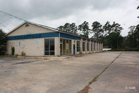

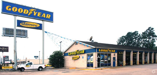
Property Detail
25811 Interstate 45
7640-01-01010
S764001 - OAK RIDGE NORTH 01, LOT 10, ACRES 0.7128
Commercialnec
Montgomery
6
Texas
B and X Area of moderate flood hazard, usually the area between the limits of the 100-year and 500-year floods.
10
2024
0.71 AC
2025
Montgomery County
691602
Houston
5,734 SF
Houston-Pasadena-The Woodlands, TX
NEARBY LISTINGS FOR SALE OR LEASE
DEMOGRAPHICS near 25811 Interstate 45
1 mile
3 mile
5 mile
2025 Total Population
12,507
70,144
192,822
2030 Population
14,480
81,214
219,775
Pop Growth 2025-2030
+ 15.78%
+ 15.78%
+ 13.98%
Average Age
37
38
38
2025 Total Households
4,885
28,060
71,510
HH Growth 2025-2030
+ 16.40%
+ 16.50%
+ 14.65%
Median Household Inc
$71,400
$90,990
$102,629
Avg Household Size
2.50
2.50
2.70
2025 Avg HH Vehicles
2.00
2.00
2.00
Median Home Value
$331,988
$338,187
$357,586
Median Year Built
1992
2000
2004
Nearby Places
Map Layers
Map Styles
 Street
 Aerial
Transit
 Traffic
 Biking
Places
Listings with unknown addresses are not visible on the map
- Restaurants
- Banks
- Shops
- Fitness
- Groceries
PUBLIC TRANSPORTATION
AIRPORT
George Bush Intcntl/Houston
Drive
Walk
Distance
George Bush Intcntl/Houston
23 min
19.0 mi
Freight Ports
Port of Houston
Drive
Walk
Distance
Port of Houston
46 min
34.7 mi
Nearby Properties
Address
Land Use
TOTAL SIZE
Lot Size
Zoning
Address
Land Use
TOTAL SIZE
Lot Size
Zoning
6,576,138 SF
186.74 AC
Address
Land Use
TOTAL SIZE
Lot Size
Zoning
1,416,950 SF
21.80 AC
Address
Land Use
TOTAL SIZE
Lot Size
Zoning
1,673,574 SF
5.10 AC
Address
Land Use
TOTAL SIZE
Lot Size
Zoning
855,268 SF
31.65 AC
6
Address
Land Use
TOTAL SIZE
Lot Size
Zoning
1,186,001 SF
13.27 AC
Address
Land Use
TOTAL SIZE
Lot Size
Zoning
718,313 SF
33.62 AC
Address
Land Use
TOTAL SIZE
Lot Size
Zoning
1,004,830 SF
7.83 AC
Address
Land Use
TOTAL SIZE
Lot Size
Zoning
709,789 SF
3.04 AC
Address
Land Use
TOTAL SIZE
Lot Size
Zoning
1,053,284 SF
2.25 AC
Address
Land Use
TOTAL SIZE
Lot Size
Zoning
707,184 SF
3.48 AC
Address
Land Use
TOTAL SIZE
Lot Size
Zoning
974,064 SF
11.79 AC
Address
Land Use
TOTAL SIZE
Lot Size
Zoning
565,113 SF
4.52 AC
Address
Land Use
TOTAL SIZE
Lot Size
Zoning
802,274 SF
2.68 AC
Address
Land Use
TOTAL SIZE
Lot Size
Zoning
469,813 SF
3.16 AC
Address
Land Use
TOTAL SIZE
Lot Size
Zoning
225,149 SF
1.07 AC
Address
Land Use
TOTAL SIZE
Lot Size
Zoning
670,665 SF
6.70 AC
Address
Land Use
TOTAL SIZE
Lot Size
Zoning
571,041 SF
4.82 AC
Address
Land Use
TOTAL SIZE
Lot Size
Zoning
438,062 SF
4.54 AC
Address
Land Use
TOTAL SIZE
Lot Size
Zoning
1,132,062 SF
3.31 AC
Address
Land Use
TOTAL SIZE
Lot Size
Zoning
457,883 SF
3.74 AC
Address
Land Use
TOTAL SIZE
Lot Size
Zoning
327,377 SF
24.02 AC
6
Address
Land Use
TOTAL SIZE
Lot Size
Zoning
473,060 SF
10.07 AC
Address
Land Use
TOTAL SIZE
Lot Size
Zoning
327,018 SF
21.91 AC
6
Address
Land Use
TOTAL SIZE
Lot Size
Zoning
368,000 SF
8.65 AC
Address
Land Use
TOTAL SIZE
Lot Size
Zoning
467,928 SF
6 AC
Address
Land Use
TOTAL SIZE
Lot Size
Zoning
296,094 SF
10.19 AC
Address
Land Use
TOTAL SIZE
Lot Size
Zoning
514,121 SF
2.01 AC
Address
Land Use
TOTAL SIZE
Lot Size
Zoning
279,413 SF
12.45 AC
6
Address
Land Use
TOTAL SIZE
Lot Size
Zoning
336,730 SF
2.41 AC
Address
Land Use
TOTAL SIZE
Lot Size
Zoning
383,484 SF
4.67 AC
The World's #1 Commercial Real Estate Marketplace
Connect with us
© 2026 CoStar Group
The information above has been obtained from sources believed reliable. While we do not doubt its accuracy we have not verified it and make no guarantee, warranty or representation about it. It is your responsibility to independently confirm its accuracy and completeness. Any projections, opinions, assumptions, or estimates used are for example only and do not represent the current or future performance of the property. The value of this transaction to you depends on tax and other factors which should be evaluated by your tax, financial, and legal advisors. You and your advisors should conduct a careful, independent investigation of the property to determine to your satisfaction the suitability of the property for your needs.