Property Record
2582 N Hwy 190 Rd W, Port Allen, LA 70767

NEARBY LISTINGS FOR SALE OR LEASE
-
-
View all Port Allen listings for sale on LoopNet.com
Property Detail
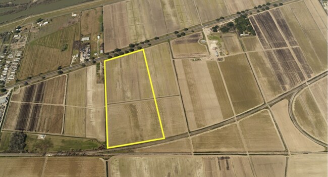
2582 N Hwy 190 Rd W
Baton Rouge, LA
Belmont Plantation
045000000100
TRACT 1A-1 CONT 35.591 AC & TRACT 3 CONT 20.563 AC (BATTURE) BEING A P/O BELMONT PLTN IN SEC 33 34 35 36 37 38 & 39 T6S R12E
Agriculturalland
W Baton Rouge
AE
Louisiana
22121C0155D
54.62 AC
2024
West Baton Rouge
2024
Baton Rouge
020302
DEMOGRAPHICS near 2582 N Hwy 190 Rd W
1 Mile
3 Mile
5 Mile
2024 Total Population
408
1,857
5,369
2029 Population
441
2,001
5,794
Pop Growth 2024-2029
+ 8.09%
+ 7.75%
+ 7.92%
Average Age
40
40
40
2024 Total Households
156
694
1,888
HH Growth 2024-2029
+ 7.69%
+ 7.64%
+ 8.00%
Median Household Inc
$82,267
$84,144
$79,174
Avg Household Size
2.60
2.60
2.60
2024 Avg HH Vehicles
2.00
2.00
2.00
Median Home Value
$262,962
$246,261
$201,087
Median Year Built
2000
2000
1995
Nearby Places
Map Layers
Map Styles
 Street
 Aerial
- Restaurants
- Banks
- Shops
- Fitness
- Groceries
PUBLIC TRANSPORTATION
AIRPORT
Baton Rouge Metro Ryan Field
DRIVE
WALK
Distance
Baton Rouge Metro Ryan Field
14 min
7.9 mi
Freight Ports
Port of Greater Baton Rouge
DRIVE
WALK
Distance
Port of Greater Baton Rouge
15 min
8.1 mi
SALE & LEASE HISTORY
LISTING DATE
SALE/LEASE

Mar 20, 2018
For Sale
Nearby Properties
Address
Land Use
TOTAL SIZE
Lot Size
Zoning
Address
Land Use
TOTAL SIZE
Lot Size
Zoning
385,397 SF
509.42 AC
Address
Land Use
TOTAL SIZE
Lot Size
Zoning
17.51 AC
Address
Land Use
TOTAL SIZE
Lot Size
Zoning
Address
Land Use
TOTAL SIZE
Lot Size
Zoning
84.58 AC
Address
Land Use
TOTAL SIZE
Lot Size
Zoning
54,382 SF
5.76 AC
Address
Land Use
TOTAL SIZE
Lot Size
Zoning
21.19 AC
Address
Land Use
TOTAL SIZE
Lot Size
Zoning
Address
Land Use
TOTAL SIZE
Lot Size
Zoning
23.36 AC
Address
Land Use
TOTAL SIZE
Lot Size
Zoning
5.93 AC
Address
Land Use
TOTAL SIZE
Lot Size
Zoning
14,340 SF
15.98 AC
Address
Land Use
TOTAL SIZE
Lot Size
Zoning
Address
Land Use
TOTAL SIZE
Lot Size
Zoning
113.15 AC
Address
Land Use
TOTAL SIZE
Lot Size
Zoning
5.67 AC
Address
Land Use
TOTAL SIZE
Lot Size
Zoning
75,420 SF
10.50 AC
Address
Land Use
TOTAL SIZE
Lot Size
Zoning
43.88 AC
Address
Land Use
TOTAL SIZE
Lot Size
Zoning
6.50 AC
Address
Land Use
TOTAL SIZE
Lot Size
Zoning
9.13 AC
Address
Land Use
TOTAL SIZE
Lot Size
Zoning
51,745 SF
11.31 AC
Address
Land Use
TOTAL SIZE
Lot Size
Zoning
22.37 AC
Address
Land Use
TOTAL SIZE
Lot Size
Zoning
3,900 SF
8.10 AC
Address
Land Use
TOTAL SIZE
Lot Size
Zoning
19,620 SF
19.44 AC
Address
Land Use
TOTAL SIZE
Lot Size
Zoning
12.97 AC
Address
Land Use
TOTAL SIZE
Lot Size
Zoning
Address
Land Use
TOTAL SIZE
Lot Size
Zoning
10,615 SF
5.51 AC
Address
Land Use
TOTAL SIZE
Lot Size
Zoning
5.37 AC
Address
Land Use
TOTAL SIZE
Lot Size
Zoning
5,000 SF
4.29 AC
Address
Land Use
TOTAL SIZE
Lot Size
Zoning
12,240 SF
5.87 AC
Address
Land Use
TOTAL SIZE
Lot Size
Zoning
4.69 AC
Address
Land Use
TOTAL SIZE
Lot Size
Zoning
25,000 SF
11.33 AC
Address
Land Use
TOTAL SIZE
Lot Size
Zoning
14.29 AC
The World's #1 Commercial Real Estate Marketplace
Connect with us
© 2026 CoStar Group
The information above has been obtained from sources believed reliable. While we do not doubt its accuracy we have not verified it and make no guarantee, warranty or representation about it. It is your responsibility to independently confirm its accuracy and completeness. Any projections, opinions, assumptions, or estimates used are for example only and do not represent the current or future performance of the property. The value of this transaction to you depends on tax and other factors which should be evaluated by your tax, financial, and legal advisors. You and your advisors should conduct a careful, independent investigation of the property to determine to your satisfaction the suitability of the property for your needs.