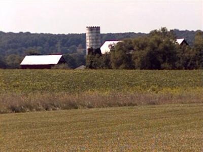
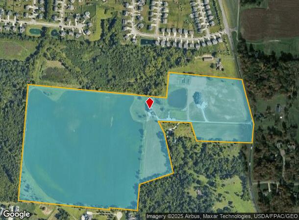
Property Record
2583 Trebein Rd, Xenia, OH 45385
NEARBY LISTINGS FOR SALE OR LEASE
Property Detail
2583 Trebein Rd
B03-0002-0039-0-0024-00
Spring Meadows
Agriculturalland
7/3/2017 0.054AC EASEMEMT TREBEIN RD
X
Greene
39057C0040E
Ohio
2024
71.97 AC
2024
Southeast Dayton
210603
Cincinnati/Dayton
9,481 SF
Dayton, OH
DEMOGRAPHICS near 2583 Trebein Rd
1 Mile
3 Mile
5 Mile
2024 Total Population
2,671
31,368
80,191
2029 Population
2,747
32,147
82,607
Pop Growth 2024-2029
+ 2.85%
+ 2.48%
+ 3.01%
Average Age
37
40
39
2024 Total Households
901
13,234
33,534
HH Growth 2024-2029
+ 2.89%
+ 2.48%
+ 3.14%
Median Household Inc
$146,742
$88,840
$77,898
Avg Household Size
2.90
2.30
2.30
2024 Avg HH Vehicles
2.00
2.00
2.00
Median Home Value
$325,349
$248,237
$210,499
Median Year Built
1997
1989
1978
Nearby Places
Map Layers
Map Styles
 Street
 Aerial
- Restaurants
- Banks
- Shops
- Fitness
- Groceries
PUBLIC TRANSPORTATION
AIRPORT
James M Cox Dayton International
DRIVE
WALK
Distance
James M Cox Dayton International
34 min
23.8 mi
Freight Ports
Port of Toledo
DRIVE
WALK
Distance
Port of Toledo
193 min
164.0 mi
Nearby Properties
Address
Land Use
TOTAL SIZE
Lot Size
Zoning
Address
Land Use
TOTAL SIZE
Lot Size
Zoning
7,087 SF
31.93 AC
MX-PUD 93-
Address
Land Use
TOTAL SIZE
Lot Size
Zoning
49,316 SF
30.39 AC
CPUD933
Address
Land Use
TOTAL SIZE
Lot Size
Zoning
101,768 SF
22.02 AC
B1
Address
Land Use
TOTAL SIZE
Lot Size
Zoning
47,424 SF
22.77 AC
RPUD917
Address
Land Use
TOTAL SIZE
Lot Size
Zoning
27,740 SF
11.16 AC
MXPUD93
Address
Land Use
TOTAL SIZE
Lot Size
Zoning
32,852 SF
18.80 AC
C-PUD 94-4
Address
Land Use
TOTAL SIZE
Lot Size
Zoning
45,522 SF
10.22 AC
Address
Land Use
TOTAL SIZE
Lot Size
Zoning
3,038 SF
13.49 AC
RPUD936
Address
Land Use
TOTAL SIZE
Lot Size
Zoning
121,392 SF
12.47 AC
Address
Land Use
TOTAL SIZE
Lot Size
Zoning
57,816 SF
9.15 AC
PD1
Address
Land Use
TOTAL SIZE
Lot Size
Zoning
594,070 SF
43.95 AC
AG
Address
Land Use
TOTAL SIZE
Lot Size
Zoning
45,204 SF
14.92 AC
PD1
Address
Land Use
TOTAL SIZE
Lot Size
Zoning
1,630 SF
8.41 AC
MXPUD93
Address
Land Use
TOTAL SIZE
Lot Size
Zoning
163,780 SF
36.93 AC
PARK
Address
Land Use
TOTAL SIZE
Lot Size
Zoning
278,290 SF
18.87 AC
AG
Address
Land Use
TOTAL SIZE
Lot Size
Zoning
121,790 SF
14.50 AC
MXPUD93
Address
Land Use
TOTAL SIZE
Lot Size
Zoning
7,772 SF
8.52 AC
R3
Address
Land Use
TOTAL SIZE
Lot Size
Zoning
14,496 SF
0.64 AC
2
Address
Land Use
TOTAL SIZE
Lot Size
Zoning
46,656 SF
10.35 AC
PD1
Address
Land Use
TOTAL SIZE
Lot Size
Zoning
58,897 SF
4.71 AC
CPUD923
Address
Land Use
TOTAL SIZE
Lot Size
Zoning
100,197 SF
9.38 AC
MX-PUD 93-
Address
Land Use
TOTAL SIZE
Lot Size
Zoning
84,032 SF
10.08 AC
RPUD936
Address
Land Use
TOTAL SIZE
Lot Size
Zoning
23,223 SF
11 AC
R1A
Address
Land Use
TOTAL SIZE
Lot Size
Zoning
122,522 SF
10.95 AC
CPUD912
Address
Land Use
TOTAL SIZE
Lot Size
Zoning
51,279 SF
2.58 AC
PD1
Address
Land Use
TOTAL SIZE
Lot Size
Zoning
24,512 SF
6.73 AC
PD1
Address
Land Use
TOTAL SIZE
Lot Size
Zoning
46,005 SF
9.33 AC
PD4
Address
Land Use
TOTAL SIZE
Lot Size
Zoning
18,230 SF
121.78 AC
RPUD936
Address
Land Use
TOTAL SIZE
Lot Size
Zoning
35,714 SF
5.46 AC
CPUD912
Address
Land Use
TOTAL SIZE
Lot Size
Zoning
17,600 SF
16.43 AC
The World's #1 Commercial Real Estate Marketplace
Connect with us
© 2026 CoStar Group
The information above has been obtained from sources believed reliable. While we do not doubt its accuracy we have not verified it and make no guarantee, warranty or representation about it. It is your responsibility to independently confirm its accuracy and completeness. Any projections, opinions, assumptions, or estimates used are for example only and do not represent the current or future performance of the property. The value of this transaction to you depends on tax and other factors which should be evaluated by your tax, financial, and legal advisors. You and your advisors should conduct a careful, independent investigation of the property to determine to your satisfaction the suitability of the property for your needs.