Property Record
2584 Us Highway 80 W, Selma, AL 36701
NEARBY LISTINGS FOR SALE OR LEASE
-
-
View all Selma listings for sale on LoopNet.com
Property Detail
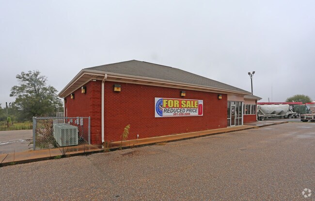
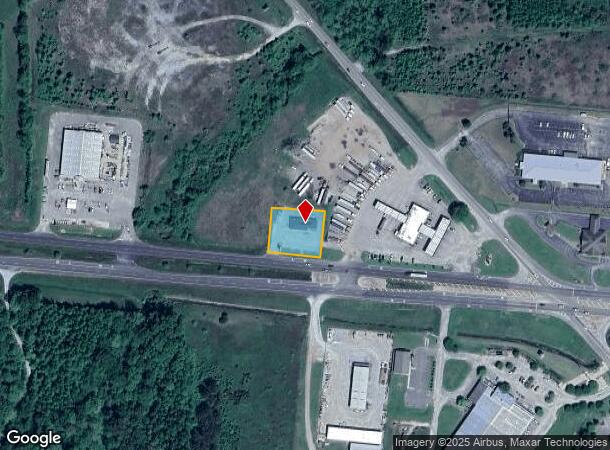
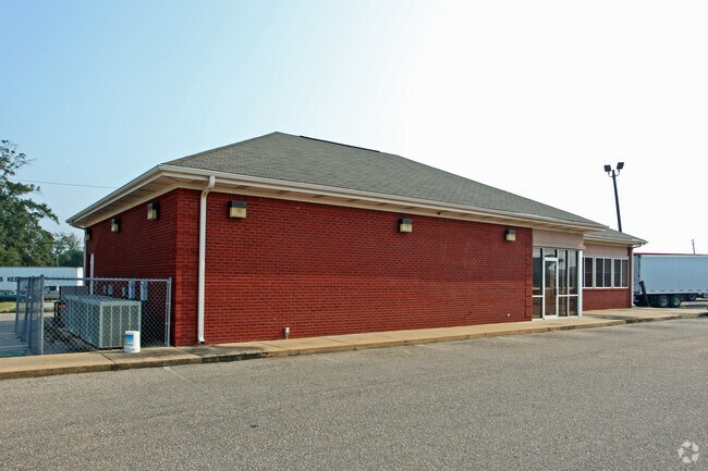
2584 Us Highway 80 W
11-05-22-0-003-002.0010
.516AC - COM INT N LINE SW/4 & W ROW ST HWY 14 TH SW 738' TO A PT ON N ROW US HWY 80; TH SE ALG SD N ROW 150'; TH NE 150'; NW 150'; SW 150' TO POB S22T17N R10E. DB 1227 PG 357 DB 1410 PG 536 DB 1511 PG 328
Restaurantbuilding
Dallas
A
Alabama
01047C0187E
0.52 AC
2024
Alabama South Area
2024
Other Market Areas
956300
Selma, AL
2,600 SF
DEMOGRAPHICS near 2584 Us Highway 80 W
1 Mile
3 Mile
5 Mile
2024 Total Population
1,225
14,831
22,894
2029 Population
1,095
13,837
21,532
Pop Growth 2024-2029
(10.61%)
(6.70%)
(5.95%)
Average Age
40
40
40
2024 Total Households
490
6,230
9,620
HH Growth 2024-2029
(10.61%)
(6.16%)
(5.38%)
Median Household Inc
$41,140
$33,891
$33,275
Avg Household Size
2.20
2.30
2.30
2024 Avg HH Vehicles
2.00
2.00
2.00
Median Home Value
$103,704
$99,744
$90,428
Median Year Built
1971
1967
1970
Nearby Places
Map Layers
Map Styles
 Street
 Aerial
- Restaurants
- Banks
- Shops
- Fitness
- Groceries
SALE & LEASE HISTORY
LISTING DATE
SALE/LEASE

Dec 06, 2019
For Sale
Nearby Properties
Address
Land Use
TOTAL SIZE
Lot Size
Zoning
Address
Land Use
TOTAL SIZE
Lot Size
Zoning
230,750 SF
7.34 AC
C
Address
Land Use
TOTAL SIZE
Lot Size
Zoning
87,391 SF
2.66 AC
Address
Land Use
TOTAL SIZE
Lot Size
Zoning
27,185 SF
1.96 AC
C
Address
Land Use
TOTAL SIZE
Lot Size
Zoning
112,856 SF
11.02 AC
I
Address
Land Use
TOTAL SIZE
Lot Size
Zoning
18,260 SF
10 AC
N
Address
Land Use
TOTAL SIZE
Lot Size
Zoning
4,814 SF
6 AC
M
Address
Land Use
TOTAL SIZE
Lot Size
Zoning
6,650 SF
10 AC
O
Address
Land Use
TOTAL SIZE
Lot Size
Zoning
64,854 SF
2.31 AC
O
Address
Land Use
TOTAL SIZE
Lot Size
Zoning
6,374 SF
3.18 AC
S
Address
Land Use
TOTAL SIZE
Lot Size
Zoning
62,913 SF
0.92 AC
Address
Land Use
TOTAL SIZE
Lot Size
Zoning
7,788 SF
8 AC
M
Address
Land Use
TOTAL SIZE
Lot Size
Zoning
1,494 SF
12 AC
S
Address
Land Use
TOTAL SIZE
Lot Size
Zoning
7,606 SF
4.80 AC
C
Address
Land Use
TOTAL SIZE
Lot Size
Zoning
34,495 SF
5.68 AC
N
Address
Land Use
TOTAL SIZE
Lot Size
Zoning
8,034 SF
22 AC
S
Address
Land Use
TOTAL SIZE
Lot Size
Zoning
49,699 SF
3.70 AC
C
Address
Land Use
TOTAL SIZE
Lot Size
Zoning
2,608 SF
10 AC
M
Address
Land Use
TOTAL SIZE
Lot Size
Zoning
50,267 SF
5.77 AC
C
Address
Land Use
TOTAL SIZE
Lot Size
Zoning
24,657 SF
4.23 AC
N
Address
Land Use
TOTAL SIZE
Lot Size
Zoning
18,248 SF
16.02 AC
N
Address
Land Use
TOTAL SIZE
Lot Size
Zoning
4,002 SF
10 AC
S
Address
Land Use
TOTAL SIZE
Lot Size
Zoning
8,359 SF
4 AC
C
Address
Land Use
TOTAL SIZE
Lot Size
Zoning
1,540 SF
7.69 AC
O
Address
Land Use
TOTAL SIZE
Lot Size
Zoning
8,715 SF
1.65 AC
S
Address
Land Use
TOTAL SIZE
Lot Size
Zoning
4,050 SF
3.38 AC
C
Address
Land Use
TOTAL SIZE
Lot Size
Zoning
14,942 SF
2 AC
C
Address
Land Use
TOTAL SIZE
Lot Size
Zoning
3,072 SF
16 AC
O
Address
Land Use
TOTAL SIZE
Lot Size
Zoning
13,661 SF
2.23 AC
Address
Land Use
TOTAL SIZE
Lot Size
Zoning
12,070 SF
3.21 AC
Address
Land Use
TOTAL SIZE
Lot Size
Zoning
9,589 SF
1.16 AC
C
The World's #1 Commercial Real Estate Marketplace
Connect with us
© 2026 CoStar Group
The information above has been obtained from sources believed reliable. While we do not doubt its accuracy we have not verified it and make no guarantee, warranty or representation about it. It is your responsibility to independently confirm its accuracy and completeness. Any projections, opinions, assumptions, or estimates used are for example only and do not represent the current or future performance of the property. The value of this transaction to you depends on tax and other factors which should be evaluated by your tax, financial, and legal advisors. You and your advisors should conduct a careful, independent investigation of the property to determine to your satisfaction the suitability of the property for your needs.