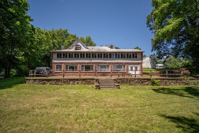
Property Record
2589 Boston Rd, Wilbraham, MA 01095

Property Detail
2589 Boston Rd
WILB-001150-000320-000624
Hampden
Officebuilding
Massachusetts
GB
624
AE The base floodplain where base flood elevations are provided. AE Zones are now used on new format FIRMs instead of A1-A30 Zones.
0.80 AC
2025
Hampden County
2025
Hartford
813601
Springfield, MA
5,085 SF
NEARBY LISTINGS FOR SALE OR LEASE
DEMOGRAPHICS near 2589 Boston Rd
1 mile
3 mile
5 mile
2025 Total Population
2,707
25,593
74,361
2030 Population
2,716
25,688
74,653
Pop Growth 2025-2030
+ 0.33%
+ 0.37%
+ 0.39%
Average Age
45
44
42
2025 Total Households
1,040
10,465
28,741
HH Growth 2025-2030
+ 0.38%
+ 0.36%
+ 0.33%
Median Household Inc
$93,965
$85,243
$80,943
Avg Household Size
2.50
2.40
2.50
2025 Avg HH Vehicles
2.00
2.00
2.00
Median Home Value
$367,093
$344,692
$311,262
Median Year Built
1958
1961
1961
Nearby Places
Map Layers
Map Styles
 Street
 Aerial
Layers
 Traffic
 Biking
Places
Listings with unknown addresses are not visible on the map
- Restaurants
- Banks
- Shops
- Fitness
- Groceries
PUBLIC TRANSPORTATION
COMMUTER RAIL
Springfield (Hartford Line - CONN DOT)
Drive
Walk
Distance
Springfield (Hartford Line - CONN DOT)
17 min
9.6 mi
AIRPORT
Bradley International
Drive
Walk
Distance
Bradley International
47 min
23.0 mi
Worcester Regional
Drive
Walk
Distance
Worcester Regional
63 min
42.8 mi
Freight Ports
Port of New Haven
Drive
Walk
Distance
Port of New Haven
98 min
73.3 mi
SALE & LEASE HISTORY
LISTING DATE
SALE/LEASE

Mar 17, 2017
For Sale
Jul 09, 2024
For Sale
Feb 07, 2018
For Sale
Nearby Properties
Address
Land Use
TOTAL SIZE
Lot Size
Zoning
Address
Land Use
TOTAL SIZE
Lot Size
Zoning
89,312 SF
38.72 AC
R1
Address
Land Use
TOTAL SIZE
Lot Size
Zoning
248,182 SF
46.27 AC
R34
Address
Land Use
TOTAL SIZE
Lot Size
Zoning
60.25 AC
Address
Land Use
TOTAL SIZE
Lot Size
Zoning
39,776 SF
8.16 AC
R2
Address
Land Use
TOTAL SIZE
Lot Size
Zoning
94,076 SF
63.12 AC
Address
Land Use
TOTAL SIZE
Lot Size
Zoning
71,911 SF
9.19 AC
Address
Land Use
TOTAL SIZE
Lot Size
Zoning
28.31 AC
Address
Land Use
TOTAL SIZE
Lot Size
Zoning
79.26 AC
R-2
Address
Land Use
TOTAL SIZE
Lot Size
Zoning
136,326 SF
65.19 AC
Address
Land Use
TOTAL SIZE
Lot Size
Zoning
15.31 AC
GB
Address
Land Use
TOTAL SIZE
Lot Size
Zoning
10,439 SF
79.80 AC
Address
Land Use
TOTAL SIZE
Lot Size
Zoning
3,534 SF
38.61 AC
R-3
Address
Land Use
TOTAL SIZE
Lot Size
Zoning
139,292 SF
12.54 AC
SB1I2
Address
Land Use
TOTAL SIZE
Lot Size
Zoning
34.44 AC
I
Address
Land Use
TOTAL SIZE
Lot Size
Zoning
13.02 AC
Address
Land Use
TOTAL SIZE
Lot Size
Zoning
116,670 SF
13 AC
GB
Address
Land Use
TOTAL SIZE
Lot Size
Zoning
34,104 SF
8 AC
R4
Address
Land Use
TOTAL SIZE
Lot Size
Zoning
1,292 SF
8.92 AC
B1
Address
Land Use
TOTAL SIZE
Lot Size
Zoning
88,560 SF
2.81 AC
GB
Address
Land Use
TOTAL SIZE
Lot Size
Zoning
193,769 SF
22.62 AC
SB1R2
Address
Land Use
TOTAL SIZE
Lot Size
Zoning
77,200 SF
10.63 AC
I
Address
Land Use
TOTAL SIZE
Lot Size
Zoning
72,793 SF
1.50 AC
Address
Land Use
TOTAL SIZE
Lot Size
Zoning
1,200 SF
1.61 AC
B2
Address
Land Use
TOTAL SIZE
Lot Size
Zoning
32,603 SF
11.42 AC
R34
Address
Land Use
TOTAL SIZE
Lot Size
Zoning
62,702 SF
3.99 AC
SB1I2
Address
Land Use
TOTAL SIZE
Lot Size
Zoning
14,371 SF
1.42 AC
GB
Address
Land Use
TOTAL SIZE
Lot Size
Zoning
25,860 SF
8.18 AC
R-2
Address
Land Use
TOTAL SIZE
Lot Size
Zoning
10,946 SF
170.18 AC
R34
Address
Land Use
TOTAL SIZE
Lot Size
Zoning
1,230 SF
38.23 AC
OS
Address
Land Use
TOTAL SIZE
Lot Size
Zoning
82.05 AC
AG
The World's #1 Commercial Real Estate Marketplace
Connect with us
© 2026 CoStar Group
The information above has been obtained from sources believed reliable. While we do not doubt its accuracy we have not verified it and make no guarantee, warranty or representation about it. It is your responsibility to independently confirm its accuracy and completeness. Any projections, opinions, assumptions, or estimates used are for example only and do not represent the current or future performance of the property. The value of this transaction to you depends on tax and other factors which should be evaluated by your tax, financial, and legal advisors. You and your advisors should conduct a careful, independent investigation of the property to determine to your satisfaction the suitability of the property for your needs.