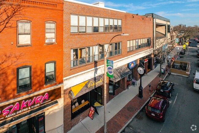
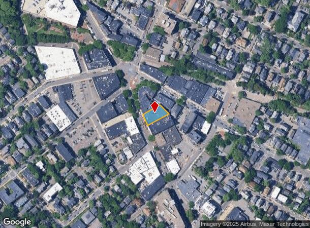
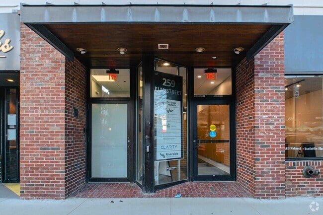
Property Record
261 Elm St, Somerville, MA 02144
Current Lease Availabilities
NEARBY LISTINGS FOR SALE OR LEASE
Property Detail
261 Elm St
SOME-000021-E000000-000016
Middlesex
Officebuilding
Massachusetts
X
16
25017C0438F
0.21 AC
2025
Somerville/Everett
2025
Boston
350900
Boston-Cambridge-Newton, MA-NH
30,030 SF
DEMOGRAPHICS near 261 Elm St
1 Mile
3 Mile
5 Mile
2024 Total Population
58,279
317,546
901,513
2029 Population
56,667
311,320
877,548
Pop Growth 2024-2029
(2.77%)
(1.96%)
(2.66%)
Average Age
36
37
37
2024 Total Households
24,703
133,774
375,854
HH Growth 2024-2029
(2.95%)
(2.03%)
(2.82%)
Median Household Inc
$122,082
$113,920
$100,074
Avg Household Size
2.20
2.20
2.20
2024 Avg HH Vehicles
1.00
1.00
1.00
Median Home Value
$917,814
$837,101
$826,975
Median Year Built
1947
1948
1949
Nearby Places
- Restaurants
- Banks
- Shops
- Fitness
- Groceries
PUBLIC TRANSPORTATION
TRANSIT/SUBWAY
Davis Station (Red Line - Massachusetts Bay Transportation Authority Subway (The T))
DRIVE
WALK
Distance
Davis Station (Red Line - Massachusetts Bay Transportation Authority Subway (The T))
1 min
1 min
0.1 mi
Porter Square Station (Red Line - Massachusetts Bay Transportation Authority Subway (The T))
DRIVE
WALK
Distance
Porter Square Station (Red Line - Massachusetts Bay Transportation Authority Subway (The T))
1 min
12 min
0.6 mi
Ball Square (Green Line B - MBTA, Green Line C - MBTA, Green Line D - MBTA, Green Line E - MBTA)
DRIVE
WALK
Distance
Ball Square (Green Line B - MBTA, Green Line C - MBTA, Green Line D - MBTA, Green Line E - MBTA)
3 min
16 min
0.8 mi
Medford/Tufts (Green Line B - MBTA, Green Line C - MBTA, Green Line D - MBTA, Green Line E - MBTA)
DRIVE
WALK
Distance
Medford/Tufts (Green Line B - MBTA, Green Line C - MBTA, Green Line D - MBTA, Green Line E - MBTA)
3 min
19 min
1.0 mi
Magoun Square (Green Line B - MBTA, Green Line C - MBTA, Green Line D - MBTA, Green Line E - MBTA)
DRIVE
WALK
Distance
Magoun Square (Green Line B - MBTA, Green Line C - MBTA, Green Line D - MBTA, Green Line E - MBTA)
3 min
20 min
1.0 mi
COMMUTER RAIL
Porter Square (Fitchburg/South Acton Line - Massachusetts Bay Transportation Authority Commuter Rail (Purple Line))
DRIVE
WALK
Distance
Porter Square (Fitchburg/South Acton Line - Massachusetts Bay Transportation Authority Commuter Rail (Purple Line))
3 min
12 min
0.6 mi
West Medford (Lowell Line - Massachusetts Bay Transportation Authority Commuter Rail (Purple Line))
DRIVE
WALK
Distance
West Medford (Lowell Line - Massachusetts Bay Transportation Authority Commuter Rail (Purple Line))
6 min
2.6 mi
AIRPORT
General Edward Lawrence Logan International
DRIVE
WALK
Distance
General Edward Lawrence Logan International
16 min
8.3 mi
Freight Ports
Port of Boston
DRIVE
WALK
Distance
Port of Boston
17 min
8.1 mi
Nearby Properties
Address
Land Use
TOTAL SIZE
Lot Size
Zoning
Address
Land Use
TOTAL SIZE
Lot Size
Zoning
439,500 SF
9.21 AC
E
Address
Land Use
TOTAL SIZE
Lot Size
Zoning
125,571 SF
3.25 AC
C-3
Address
Land Use
TOTAL SIZE
Lot Size
Zoning
530,200 SF
62.08 AC
E
Address
Land Use
TOTAL SIZE
Lot Size
Zoning
173,400 SF
1.14 AC
MXD
Address
Land Use
TOTAL SIZE
Lot Size
Zoning
142,458 SF
1.67 AC
C-3
Address
Land Use
TOTAL SIZE
Lot Size
Zoning
230,394 SF
0.60 AC
MXD
Address
Land Use
TOTAL SIZE
Lot Size
Zoning
304,349 SF
1.72 AC
Address
Land Use
TOTAL SIZE
Lot Size
Zoning
3.52 AC
C-3
Address
Land Use
TOTAL SIZE
Lot Size
Zoning
239,377 SF
0.71 AC
MXD
Address
Land Use
TOTAL SIZE
Lot Size
Zoning
419,722 SF
2.03 AC
RC
Address
Land Use
TOTAL SIZE
Lot Size
Zoning
283,554 SF
2.76 AC
O-2A
Address
Land Use
TOTAL SIZE
Lot Size
Zoning
54,500 SF
4.01 AC
O-2A
Address
Land Use
TOTAL SIZE
Lot Size
Zoning
2.81 AC
O-2
Address
Land Use
TOTAL SIZE
Lot Size
Zoning
47.67 AC
UN
Address
Land Use
TOTAL SIZE
Lot Size
Zoning
4,355 SF
13.12 AC
E
Address
Land Use
TOTAL SIZE
Lot Size
Zoning
646,546 SF
89.28 AC
ROD
Address
Land Use
TOTAL SIZE
Lot Size
Zoning
386,825 SF
10.67 AC
Address
Land Use
TOTAL SIZE
Lot Size
Zoning
2.87 AC
O-2A
Address
Land Use
TOTAL SIZE
Lot Size
Zoning
155,818 SF
5.33 AC
OS
Address
Land Use
TOTAL SIZE
Lot Size
Zoning
506,534 SF
2.75 AC
C
Address
Land Use
TOTAL SIZE
Lot Size
Zoning
213,834 SF
1.48 AC
SD-4
Address
Land Use
TOTAL SIZE
Lot Size
Zoning
569,990 SF
0.46 AC
HR
Address
Land Use
TOTAL SIZE
Lot Size
Zoning
2.25 AC
SD-12
Address
Land Use
TOTAL SIZE
Lot Size
Zoning
224,115 SF
2.35 AC
O-2A
Address
Land Use
TOTAL SIZE
Lot Size
Zoning
158,526 SF
0.79 AC
MXD
Address
Land Use
TOTAL SIZE
Lot Size
Zoning
282,112 SF
2.51 AC
IA-1
Address
Land Use
TOTAL SIZE
Lot Size
Zoning
244,008 SF
4 AC
SD-4A
Address
Land Use
TOTAL SIZE
Lot Size
Zoning
174,764 SF
1.83 AC
C-3
Address
Land Use
TOTAL SIZE
Lot Size
Zoning
17,788 SF
8.32 AC
C-1
Address
Land Use
TOTAL SIZE
Lot Size
Zoning
110,299 SF
0.82 AC
C-3
The World's #1 Commercial Real Estate Marketplace
Connect with us
© 2025 CoStar Group
The information above has been obtained from sources believed reliable. While we do not doubt its accuracy we have not verified it and make no guarantee, warranty or representation about it. It is your responsibility to independently confirm its accuracy and completeness. Any projections, opinions, assumptions, or estimates used are for example only and do not represent the current or future performance of the property. The value of this transaction to you depends on tax and other factors which should be evaluated by your tax, financial, and legal advisors. You and your advisors should conduct a careful, independent investigation of the property to determine to your satisfaction the suitability of the property for your needs.