Property Record
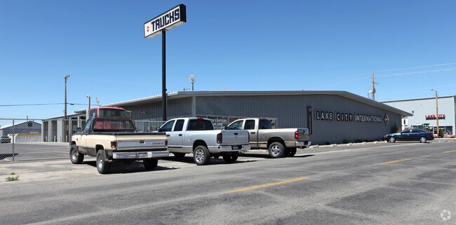
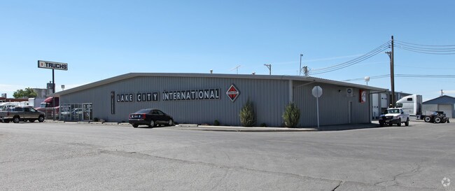
259 4Th Ave W, Twin Falls, ID 83301

Property Detail
259 4Th Ave W
RPT0001143001AA
TWIN FALLS TOWNSITE FINAL & AMD LOTS 1 THRU 5 & ADJ VACATED ALLEY BLOCK 143 (16-10-17)
Realpropertynec
Twin Falls
M-2
Idaho
B and X Area of moderate flood hazard, usually the area between the limits of the 100-year and 500-year floods.
1-5
2025
0.78 AC
2025
Idaho South Area
001100
Other Market Areas
18,971 SF
Twin Falls, ID
NEARBY LISTINGS FOR SALE OR LEASE
DEMOGRAPHICS near 259 4Th Ave W
1 mile
3 mile
5 mile
2024 Total Population
11,177
57,310
66,360
2029 Population
11,744
60,473
70,060
Pop Growth 2024-2029
+ 5.07%
+ 5.52%
+ 5.58%
Average Age
37
38
38
2024 Total Households
4,419
21,352
24,500
HH Growth 2024-2029
+ 5.20%
+ 5.61%
+ 5.67%
Median Household Inc
$56,167
$64,240
$66,175
Avg Household Size
2.40
2.60
2.60
2024 Avg HH Vehicles
2.00
2.00
2.00
Median Home Value
$276,941
$319,563
$330,267
Median Year Built
1951
1983
1987
Nearby Places
Map Layers
Map Styles
 Street
 Aerial
Transit
 Traffic
 Biking
Places
Listings with unknown addresses are not visible on the map
- Restaurants
- Banks
- Shops
- Fitness
- Groceries
SALE & LEASE HISTORY
LISTING DATE
SALE/LEASE

Sep 23, 2016
For Sale
Sep 23, 2016
For Sale
Mar 27, 2017
For Sale
Nearby Properties
Address
Land Use
TOTAL SIZE
Lot Size
Zoning
Address
Land Use
TOTAL SIZE
Lot Size
Zoning
38,811 SF
40.92 AC
C-1
Address
Land Use
TOTAL SIZE
Lot Size
Zoning
6,384 SF
5.89 AC
M-2
Address
Land Use
TOTAL SIZE
Lot Size
Zoning
225,980 SF
24.47 AC
C-1
Address
Land Use
TOTAL SIZE
Lot Size
Zoning
382,261 SF
11.44 AC
M-2
Address
Land Use
TOTAL SIZE
Lot Size
Zoning
8.53 AC
C-1
Address
Land Use
TOTAL SIZE
Lot Size
Zoning
28,224 SF
7.10 AC
C-1
Address
Land Use
TOTAL SIZE
Lot Size
Zoning
48,191 SF
3.46 AC
C-1
Address
Land Use
TOTAL SIZE
Lot Size
Zoning
167,708 SF
14.90 AC
C-1
Address
Land Use
TOTAL SIZE
Lot Size
Zoning
24,284 SF
3.68 AC
C-1
Address
Land Use
TOTAL SIZE
Lot Size
Zoning
160,432 SF
11.25 AC
C-1
Address
Land Use
TOTAL SIZE
Lot Size
Zoning
137,048 SF
12.66 AC
C-1
Address
Land Use
TOTAL SIZE
Lot Size
Zoning
71,798 SF
5.97 AC
C-1
Address
Land Use
TOTAL SIZE
Lot Size
Zoning
76,913 SF
2.88 AC
C-1
Address
Land Use
TOTAL SIZE
Lot Size
Zoning
240,740 SF
6.74 AC
M-2
Address
Land Use
TOTAL SIZE
Lot Size
Zoning
91,588 SF
3.16 AC
C-1
Address
Land Use
TOTAL SIZE
Lot Size
Zoning
116,676 SF
12.13 AC
C-1
Address
Land Use
TOTAL SIZE
Lot Size
Zoning
48,730 SF
4.67 AC
C-1
Address
Land Use
TOTAL SIZE
Lot Size
Zoning
9,440 SF
7.05 AC
R-6
Address
Land Use
TOTAL SIZE
Lot Size
Zoning
71,900 SF
2.67 AC
C-1
Address
Land Use
TOTAL SIZE
Lot Size
Zoning
114,844 SF
7.70 AC
C-1
Address
Land Use
TOTAL SIZE
Lot Size
Zoning
127,520 SF
16.82 AC
M-2
Address
Land Use
TOTAL SIZE
Lot Size
Zoning
20,016 SF
4.40 AC
R-6
Address
Land Use
TOTAL SIZE
Lot Size
Zoning
65,565 SF
2.14 AC
C-1
Address
Land Use
TOTAL SIZE
Lot Size
Zoning
40,730 SF
0.36 AC
O-T
Address
Land Use
TOTAL SIZE
Lot Size
Zoning
78,849 SF
18.66 AC
M-2
Address
Land Use
TOTAL SIZE
Lot Size
Zoning
29,988 SF
3.80 AC
Address
Land Use
TOTAL SIZE
Lot Size
Zoning
24,650 SF
2.13 AC
C-1
Address
Land Use
TOTAL SIZE
Lot Size
Zoning
9,220 SF
5.92 AC
R-4
Address
Land Use
TOTAL SIZE
Lot Size
Zoning
5,234 SF
5 AC
R-6
Address
Land Use
TOTAL SIZE
Lot Size
Zoning
27,652 SF
4.64 AC
C-1
The World's #1 Commercial Real Estate Marketplace
Connect with us
© 2026 CoStar Group
The information above has been obtained from sources believed reliable. While we do not doubt its accuracy we have not verified it and make no guarantee, warranty or representation about it. It is your responsibility to independently confirm its accuracy and completeness. Any projections, opinions, assumptions, or estimates used are for example only and do not represent the current or future performance of the property. The value of this transaction to you depends on tax and other factors which should be evaluated by your tax, financial, and legal advisors. You and your advisors should conduct a careful, independent investigation of the property to determine to your satisfaction the suitability of the property for your needs.