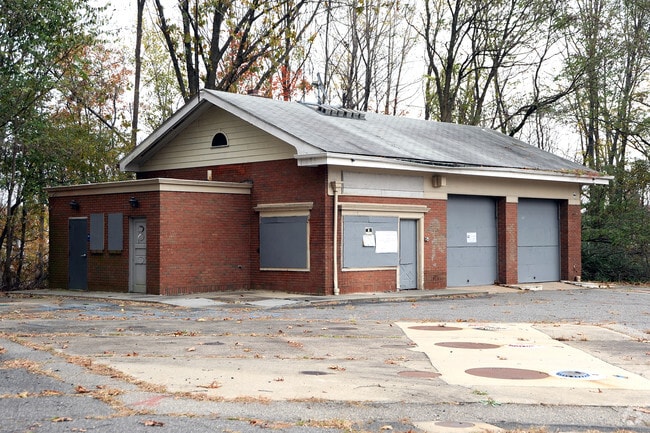
Property Record
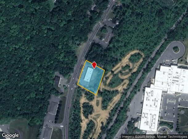
259 Us Highway 206, Flanders, NJ 07836
NEARBY LISTINGS FOR SALE OR LEASE
Property Detail
259 Us Highway 206
Newark, NJ-PA
ADDITIONAL LOTS: B24 L39-A
27-05401-0000-00017
Morris
Servicestation
New Jersey
2024
17
2025
1.19 AC
046104
Western Morris
6,708 SF
Northern New Jersey
DEMOGRAPHICS near 259 Us Highway 206
1 Mile
3 Mile
5 Mile
2024 Total Population
3,651
25,024
65,820
2029 Population
3,656
24,948
65,708
Pop Growth 2024-2029
+ 0.14%
(0.30%)
(0.17%)
Average Age
42
41
41
2024 Total Households
1,266
9,261
24,187
HH Growth 2024-2029
+ 0.24%
(0.58%)
(0.29%)
Median Household Inc
$157,569
$127,469
$125,788
Avg Household Size
2.80
2.60
2.70
2024 Avg HH Vehicles
2.00
2.00
2.00
Median Home Value
$416,987
$436,163
$446,640
Median Year Built
1971
1975
1975
Nearby Places
Map Layers
Map Styles
 Street
 Aerial
- Restaurants
- Banks
- Shops
- Fitness
- Groceries
PUBLIC TRANSPORTATION
COMMUTER RAIL
Netcong (Montclair-Boonton Line - NJ Transit Commuter Rail (NJ Transit), Morris & Essex Morristown Line - NJ Transit Commuter Rail (NJ Transit))
DRIVE
WALK
Distance
Netcong (Montclair-Boonton Line - NJ Transit Commuter Rail (NJ Transit), Morris & Essex Morristown Line - NJ Transit Commuter Rail (NJ Transit))
9 min
4.9 mi
Mount Olive (Montclair-Boonton Line - NJ Transit Commuter Rail (NJ Transit), Morris & Essex Morristown Line - NJ Transit Commuter Rail (NJ Transit))
DRIVE
WALK
Distance
Mount Olive (Montclair-Boonton Line - NJ Transit Commuter Rail (NJ Transit), Morris & Essex Morristown Line - NJ Transit Commuter Rail (NJ Transit))
12 min
6.8 mi
AIRPORT
Newark Liberty International
DRIVE
WALK
Distance
Newark Liberty International
53 min
39.0 mi
Freight Ports
Maher Terminal
DRIVE
WALK
Distance
Maher Terminal
57 min
40.1 mi
SALE & LEASE HISTORY
LISTING DATE
SALE/LEASE

Sep 24, 2016
For Sale
Dec 09, 2020
For Sale
Nearby Properties
Address
Land Use
TOTAL SIZE
Lot Size
Zoning
Address
Land Use
TOTAL SIZE
Lot Size
Zoning
174.40 AC
R-5
Address
Land Use
TOTAL SIZE
Lot Size
Zoning
242 AC
G-I
Address
Land Use
TOTAL SIZE
Lot Size
Zoning
1,017 SF
1,485.15 AC
P
Address
Land Use
TOTAL SIZE
Lot Size
Zoning
49.34 AC
R-5
Address
Land Use
TOTAL SIZE
Lot Size
Zoning
50.50 AC
R-5
Address
Land Use
TOTAL SIZE
Lot Size
Zoning
323,779 SF
32.65 AC
L-I
Address
Land Use
TOTAL SIZE
Lot Size
Zoning
350,000 SF
49.35 AC
P
Address
Land Use
TOTAL SIZE
Lot Size
Zoning
720 SF
1,022.40 AC
R-2
Address
Land Use
TOTAL SIZE
Lot Size
Zoning
201,933 SF
26.04 AC
R-2
Address
Land Use
TOTAL SIZE
Lot Size
Zoning
29.29 AC
R-5
Address
Land Use
TOTAL SIZE
Lot Size
Zoning
6.74 AC
TC
Address
Land Use
TOTAL SIZE
Lot Size
Zoning
154,902 SF
18.96 AC
C-2
Address
Land Use
TOTAL SIZE
Lot Size
Zoning
49.34 AC
R-5
Address
Land Use
TOTAL SIZE
Lot Size
Zoning
49,548 SF
19.99 AC
P
Address
Land Use
TOTAL SIZE
Lot Size
Zoning
91,518 SF
5 AC
R3SC
Address
Land Use
TOTAL SIZE
Lot Size
Zoning
81,865 SF
20.32 AC
C-2
Address
Land Use
TOTAL SIZE
Lot Size
Zoning
158,800 SF
18.40 AC
G-I
Address
Land Use
TOTAL SIZE
Lot Size
Zoning
36,322 SF
13.31 AC
GU
Address
Land Use
TOTAL SIZE
Lot Size
Zoning
41,310 SF
14.50 AC
GU
Address
Land Use
TOTAL SIZE
Lot Size
Zoning
27,400 SF
16.57 AC
RRAA
Address
Land Use
TOTAL SIZE
Lot Size
Zoning
85,802 SF
23.67 AC
P
Address
Land Use
TOTAL SIZE
Lot Size
Zoning
15 AC
OS
Address
Land Use
TOTAL SIZE
Lot Size
Zoning
87.06 AC
FTZ4
Address
Land Use
TOTAL SIZE
Lot Size
Zoning
62,264 SF
29.92 AC
P
Address
Land Use
TOTAL SIZE
Lot Size
Zoning
52,027 SF
33.23 AC
R-2
Address
Land Use
TOTAL SIZE
Lot Size
Zoning
83,616 SF
36.79 AC
G-I
Address
Land Use
TOTAL SIZE
Lot Size
Zoning
36,532 SF
19.03 AC
P
Address
Land Use
TOTAL SIZE
Lot Size
Zoning
Address
Land Use
TOTAL SIZE
Lot Size
Zoning
53.60 AC
OR-5
Address
Land Use
TOTAL SIZE
Lot Size
Zoning
30,936 SF
4.10 AC
R-1
The World's #1 Commercial Real Estate Marketplace
Connect with us
© 2025 CoStar Group
The information above has been obtained from sources believed reliable. While we do not doubt its accuracy we have not verified it and make no guarantee, warranty or representation about it. It is your responsibility to independently confirm its accuracy and completeness. Any projections, opinions, assumptions, or estimates used are for example only and do not represent the current or future performance of the property. The value of this transaction to you depends on tax and other factors which should be evaluated by your tax, financial, and legal advisors. You and your advisors should conduct a careful, independent investigation of the property to determine to your satisfaction the suitability of the property for your needs.