Property Record
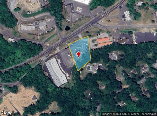
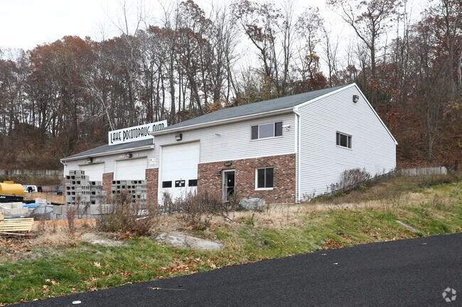
259 W High St, East Hampton, CT 06424

NEARBY LISTINGS FOR SALE OR LEASE
-
-
View all East Hampton listings for lease on LoopNet.com
Property Detail
259 W High St
EHAM-000006-000012-000009-000004
Grovenors Grove
Commercialnec
Middlesex
X
Connecticut
09007C0135G
9
2025
1.40 AC
2025
East Hampton/East Haddam
550202
Hartford
3,780 SF
Hartford-West Hartford-East Hartford, CT
DEMOGRAPHICS near 259 W High St
1 mile
3 mile
5 mile
2024 Total Population
1,030
9,158
25,323
2029 Population
1,001
9,021
25,077
Pop Growth 2024-2029
(2.82%)
(1.50%)
(0.97%)
Average Age
44
43
43
2024 Total Households
396
3,739
10,180
HH Growth 2024-2029
(3.03%)
(1.68%)
(1.07%)
Median Household Inc
$99,690
$111,691
$107,706
Avg Household Size
2.50
2.40
2.40
2024 Avg HH Vehicles
2.00
2.00
2.00
Median Home Value
$255,027
$282,812
$275,369
Median Year Built
1969
1969
1966
Nearby Places
Map Layers
Map Styles
 Street
 Aerial
Transit
 Traffic
 Biking
Places
Listings with unknown addresses are not visible on the map
- Restaurants
- Banks
- Shops
- Fitness
- Groceries
PUBLIC TRANSPORTATION
AIRPORT
Bradley International
Drive
Walk
Distance
Bradley International
56 min
34.0 mi
Tweed/New Haven
Drive
Walk
Distance
Tweed/New Haven
59 min
36.3 mi
Freight Ports
Port of New Haven
Drive
Walk
Distance
Port of New Haven
53 min
35.2 mi
SALE & LEASE HISTORY
LISTING DATE
SALE/LEASE

Nov 16, 2016
For Lease
Nearby Properties
Address
Land Use
TOTAL SIZE
Lot Size
Zoning
Address
Land Use
TOTAL SIZE
Lot Size
Zoning
368.70 AC
I-3
Address
Land Use
TOTAL SIZE
Lot Size
Zoning
63.50 AC
I-3
Address
Land Use
TOTAL SIZE
Lot Size
Zoning
127,409 SF
46.70 AC
R-1S
Address
Land Use
TOTAL SIZE
Lot Size
Zoning
75,272 SF
24.50 AC
R-2S
Address
Land Use
TOTAL SIZE
Lot Size
Zoning
81,849 SF
15 AC
R-2
Address
Land Use
TOTAL SIZE
Lot Size
Zoning
11.13 AC
C
Address
Land Use
TOTAL SIZE
Lot Size
Zoning
558.80 AC
RL
Address
Land Use
TOTAL SIZE
Lot Size
Zoning
77.80 AC
B1
Address
Land Use
TOTAL SIZE
Lot Size
Zoning
2.98 AC
C
Address
Land Use
TOTAL SIZE
Lot Size
Zoning
67,280 SF
4.69 AC
C
Address
Land Use
TOTAL SIZE
Lot Size
Zoning
36,865 SF
6.76 AC
R-1S
Address
Land Use
TOTAL SIZE
Lot Size
Zoning
10.53 AC
R-2S
Address
Land Use
TOTAL SIZE
Lot Size
Zoning
19,210 SF
1.85 AC
C
Address
Land Use
TOTAL SIZE
Lot Size
Zoning
39,482 SF
2.54 AC
I
Address
Land Use
TOTAL SIZE
Lot Size
Zoning
16,270 SF
3.01 AC
VC
Address
Land Use
TOTAL SIZE
Lot Size
Zoning
2.96 AC
PO/R
Address
Land Use
TOTAL SIZE
Lot Size
Zoning
7,680 SF
8.63 AC
C
Address
Land Use
TOTAL SIZE
Lot Size
Zoning
16.70 AC
I-3
Address
Land Use
TOTAL SIZE
Lot Size
Zoning
26,137 SF
2.43 AC
R-2
Address
Land Use
TOTAL SIZE
Lot Size
Zoning
1.70 AC
C
Address
Land Use
TOTAL SIZE
Lot Size
Zoning
Address
Land Use
TOTAL SIZE
Lot Size
Zoning
3.93 AC
I
Address
Land Use
TOTAL SIZE
Lot Size
Zoning
4.96 AC
R-2S
Address
Land Use
TOTAL SIZE
Lot Size
Zoning
3.22 AC
B1
Address
Land Use
TOTAL SIZE
Lot Size
Zoning
17,472 SF
0.66 AC
DD
Address
Land Use
TOTAL SIZE
Lot Size
Zoning
6.10 AC
R-2S
Address
Land Use
TOTAL SIZE
Lot Size
Zoning
10,800 SF
5.20 AC
C
Address
Land Use
TOTAL SIZE
Lot Size
Zoning
4,968 SF
0.72 AC
C
Address
Land Use
TOTAL SIZE
Lot Size
Zoning
4.74 AC
R-2
Address
Land Use
TOTAL SIZE
Lot Size
Zoning
8.28 AC
B1
The World's #1 Commercial Real Estate Marketplace
Connect with us
© 2026 CoStar Group
The information above has been obtained from sources believed reliable. While we do not doubt its accuracy we have not verified it and make no guarantee, warranty or representation about it. It is your responsibility to independently confirm its accuracy and completeness. Any projections, opinions, assumptions, or estimates used are for example only and do not represent the current or future performance of the property. The value of this transaction to you depends on tax and other factors which should be evaluated by your tax, financial, and legal advisors. You and your advisors should conduct a careful, independent investigation of the property to determine to your satisfaction the suitability of the property for your needs.