Property Record
2590 W 9000 S, West Jordan, UT 84088
NEARBY LISTINGS FOR SALE OR LEASE
Property Detail
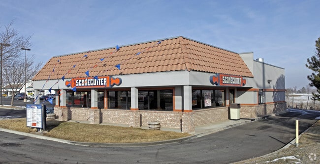
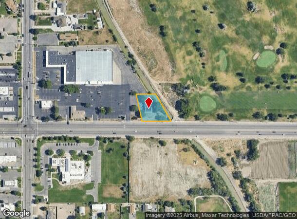
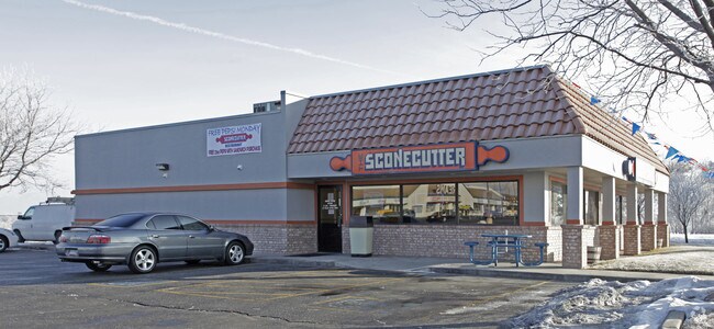
2590 W 9000 S
27-04-251-020-0000
Wayland Station At Old Farm Condominium
Restaurantdrivein
BEG W 1942.35 FT & N 12^53 W 53.73 FT FR E 1/4 COR SEC 4, T3S, R 1W, SLM; N 12^53 W 167.67 FT; E 119.76 FT TO CANAL; S30; E 188.92 FT ALG CANAL; N 89^5651 W 176.84 FT TO BEG. .63 AC. 5481-748,749 5481-0750 5573-1943 5799-1112 5807-05796689-1967 6913-
X
Salt Lake
49035C0429G
Utah
2024
0.63 AC
2025
Southwest Valley
112921
Salt Lake City
2,544 SF
Salt Lake City, UT
DEMOGRAPHICS near 2590 W 9000 S
1 Mile
3 Mile
5 Mile
2024 Total Population
13,293
116,494
345,040
2029 Population
13,395
117,746
350,753
Pop Growth 2024-2029
+ 0.77%
+ 1.07%
+ 1.66%
Average Age
38
37
36
2024 Total Households
4,569
37,021
110,587
HH Growth 2024-2029
+ 0.72%
+ 1.10%
+ 1.60%
Median Household Inc
$85,723
$91,461
$89,765
Avg Household Size
2.80
3.10
3.10
2024 Avg HH Vehicles
2.00
2.00
2.00
Median Home Value
$449,182
$449,676
$439,394
Median Year Built
1993
1995
1995
Nearby Places
Map Layers
Map Styles
 Street
 Aerial
- Restaurants
- Banks
- Shops
- Fitness
- Groceries
PUBLIC TRANSPORTATION
COMMUTER RAIL
DRIVE
WALK
Distance
9 min
4.4 mi
DRIVE
WALK
Distance
15 min
8.8 mi
AIRPORT
Salt Lake City International
DRIVE
WALK
Distance
Salt Lake City International
24 min
15.0 mi
Provo Municipal
DRIVE
WALK
Distance
Provo Municipal
45 min
35.7 mi
Nearby Properties
Address
Land Use
TOTAL SIZE
Lot Size
Zoning
Address
Land Use
TOTAL SIZE
Lot Size
Zoning
733,215 SF
58.65 AC
M-1
Address
Land Use
TOTAL SIZE
Lot Size
Zoning
198,801 SF
8.36 AC
R-3-20
Address
Land Use
TOTAL SIZE
Lot Size
Zoning
427,884 SF
18.22 AC
JB-4
Address
Land Use
TOTAL SIZE
Lot Size
Zoning
153,245 SF
27.10 AC
PUD137
Address
Land Use
TOTAL SIZE
Lot Size
Zoning
497,522 SF
16.43 AC
MH
Address
Land Use
TOTAL SIZE
Lot Size
Zoning
372,355 SF
13.80 AC
C-F
Address
Land Use
TOTAL SIZE
Lot Size
Zoning
679,800 SF
18.14 AC
BJ-1-3
Address
Land Use
TOTAL SIZE
Lot Size
Zoning
448,232 SF
9.08 AC
PC
Address
Land Use
TOTAL SIZE
Lot Size
Zoning
74,120 SF
12.61 AC
BJ
Address
Land Use
TOTAL SIZE
Lot Size
Zoning
410,435 SF
2.43 AC
P-C
Address
Land Use
TOTAL SIZE
Lot Size
Zoning
77,525 SF
2.35 AC
P-C
Address
Land Use
TOTAL SIZE
Lot Size
Zoning
45,924 SF
18.15 AC
R-3-20
Address
Land Use
TOTAL SIZE
Lot Size
Zoning
114.79 AC
PF
Address
Land Use
TOTAL SIZE
Lot Size
Zoning
143,314 SF
2.30 AC
P-C
Address
Land Use
TOTAL SIZE
Lot Size
Zoning
398,447 SF
11.04 AC
BMHU
Address
Land Use
TOTAL SIZE
Lot Size
Zoning
289,838 SF
24.11 AC
BJ-3
Address
Land Use
TOTAL SIZE
Lot Size
Zoning
117,521 SF
57.92 AC
PF
Address
Land Use
TOTAL SIZE
Lot Size
Zoning
28,515 SF
6.77 AC
PC
Address
Land Use
TOTAL SIZE
Lot Size
Zoning
40,042 SF
15.43 AC
R-3-16
Address
Land Use
TOTAL SIZE
Lot Size
Zoning
203,064 SF
5.91 AC
PC
Address
Land Use
TOTAL SIZE
Lot Size
Zoning
120,929 SF
7.23 AC
PC
Address
Land Use
TOTAL SIZE
Lot Size
Zoning
174,582 SF
18.60 AC
BJ
Address
Land Use
TOTAL SIZE
Lot Size
Zoning
76,837 SF
50.54 AC
P-F
Address
Land Use
TOTAL SIZE
Lot Size
Zoning
268,200 SF
44.38 AC
PF
Address
Land Use
TOTAL SIZE
Lot Size
Zoning
36,708 SF
12.83 AC
R-3-16
Address
Land Use
TOTAL SIZE
Lot Size
Zoning
314,994 SF
10 AC
R-3
Address
Land Use
TOTAL SIZE
Lot Size
Zoning
105,956 SF
37.60 AC
4180
Address
Land Use
TOTAL SIZE
Lot Size
Zoning
118.74 AC
4180
Address
Land Use
TOTAL SIZE
Lot Size
Zoning
66,211 SF
9.12 AC
BJ
Address
Land Use
TOTAL SIZE
Lot Size
Zoning
80 AC
PF
The World's #1 Commercial Real Estate Marketplace
Connect with us
© 2025 CoStar Group
The information above has been obtained from sources believed reliable. While we do not doubt its accuracy we have not verified it and make no guarantee, warranty or representation about it. It is your responsibility to independently confirm its accuracy and completeness. Any projections, opinions, assumptions, or estimates used are for example only and do not represent the current or future performance of the property. The value of this transaction to you depends on tax and other factors which should be evaluated by your tax, financial, and legal advisors. You and your advisors should conduct a careful, independent investigation of the property to determine to your satisfaction the suitability of the property for your needs.