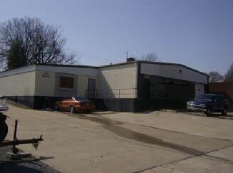
Property Record
2599 Broad Ave, Memphis, TN 38112


NEARBY LISTINGS FOR SALE OR LEASE
Property Detail
2599 Broad Ave
Memphis, TN-MS-AR
Binghampton
03-3041-0-0009
SS BROAD
Warehouse
Shelby
X
Tennessee
47157C0290F
11-12
2024
0.14 AC
2025
Northwest
002700
Memphis
4,716 SF
DEMOGRAPHICS near 2599 Broad Ave
1 Mile
3 Mile
5 Mile
2024 Total Population
11,872
106,964
248,070
2029 Population
12,160
107,172
248,586
Pop Growth 2024-2029
+ 2.43%
+ 0.19%
+ 0.21%
Average Age
36
38
38
2024 Total Households
4,749
47,347
106,153
HH Growth 2024-2029
+ 2.46%
+ 0.07%
+ 0.10%
Median Household Inc
$32,650
$44,008
$41,930
Avg Household Size
2.30
2.10
2.20
2024 Avg HH Vehicles
1.00
1.00
1.00
Median Home Value
$154,411
$243,413
$171,322
Median Year Built
1956
1952
1957
Nearby Places
Map Layers
Map Styles
 Street
 Aerial
- Restaurants
- Banks
- Shops
- Fitness
- Groceries
PUBLIC TRANSPORTATION
COMMUTER RAIL
Central Station (Riverfront Loop - Memphis Area Transit Authority Trolley (MataTrolley))
DRIVE
WALK
Distance
Central Station (Riverfront Loop - Memphis Area Transit Authority Trolley (MataTrolley))
13 min
6.6 mi
AIRPORT
Memphis International
DRIVE
WALK
Distance
Memphis International
14 min
8.4 mi
Nearby Properties
Address
Land Use
TOTAL SIZE
Lot Size
Zoning
Address
Land Use
TOTAL SIZE
Lot Size
Zoning
138,093 SF
7.05 AC
EMP
Address
Land Use
TOTAL SIZE
Lot Size
Zoning
218,327 SF
4.89 AC
R-6
Address
Land Use
TOTAL SIZE
Lot Size
Zoning
115,053 SF
4.63 AC
CMU-1
Address
Land Use
TOTAL SIZE
Lot Size
Zoning
2,137 SF
346 AC
R-15
Address
Land Use
TOTAL SIZE
Lot Size
Zoning
82,064 SF
3.53 AC
CMP-1
Address
Land Use
TOTAL SIZE
Lot Size
Zoning
99,732 SF
1.08 AC
CMU-3
Address
Land Use
TOTAL SIZE
Lot Size
Zoning
100,246 SF
0.93 AC
CMU-3
Address
Land Use
TOTAL SIZE
Lot Size
Zoning
33,391 SF
1.26 AC
CMU-1
Address
Land Use
TOTAL SIZE
Lot Size
Zoning
87,504 SF
0.88 AC
CMU-3
Address
Land Use
TOTAL SIZE
Lot Size
Zoning
222,671 SF
8.77 AC
EMP
Address
Land Use
TOTAL SIZE
Lot Size
Zoning
53,088 SF
1.51 AC
CMU-3
Address
Land Use
TOTAL SIZE
Lot Size
Zoning
38,348 SF
1.74 AC
RW
Address
Land Use
TOTAL SIZE
Lot Size
Zoning
120.15 AC
RU-1
Address
Land Use
TOTAL SIZE
Lot Size
Zoning
118,073 SF
4.75 AC
CMU-1
Address
Land Use
TOTAL SIZE
Lot Size
Zoning
114,326 SF
1.99 AC
R-6
Address
Land Use
TOTAL SIZE
Lot Size
Zoning
96 AC
R-10
Address
Land Use
TOTAL SIZE
Lot Size
Zoning
17,438 SF
25.84 AC
RU-3
Address
Land Use
TOTAL SIZE
Lot Size
Zoning
66,580 SF
3.75 AC
RU-3
Address
Land Use
TOTAL SIZE
Lot Size
Zoning
46,612 SF
2.86 AC
CMU-3
Address
Land Use
TOTAL SIZE
Lot Size
Zoning
699,184 SF
19.67 AC
IH
Address
Land Use
TOTAL SIZE
Lot Size
Zoning
104.22 AC
R-15
Address
Land Use
TOTAL SIZE
Lot Size
Zoning
26.98 AC
CMU-3
Address
Land Use
TOTAL SIZE
Lot Size
Zoning
40,270 SF
2 AC
Address
Land Use
TOTAL SIZE
Lot Size
Zoning
66,728 SF
346 AC
RS-15
Address
Land Use
TOTAL SIZE
Lot Size
Zoning
87,283 SF
2.14 AC
CMU-1
Address
Land Use
TOTAL SIZE
Lot Size
Zoning
69,204 SF
4.54 AC
CMU-3
Address
Land Use
TOTAL SIZE
Lot Size
Zoning
55,082 SF
2.31 AC
CMU-1
Address
Land Use
TOTAL SIZE
Lot Size
Zoning
190,456 SF
13.71 AC
CMU-1
Address
Land Use
TOTAL SIZE
Lot Size
Zoning
399,662 SF
27.28 AC
EMP
Address
Land Use
TOTAL SIZE
Lot Size
Zoning
225,141 SF
3.06 AC
CMU-3
The World's #1 Commercial Real Estate Marketplace
Connect with us
© 2025 CoStar Group
The information above has been obtained from sources believed reliable. While we do not doubt its accuracy we have not verified it and make no guarantee, warranty or representation about it. It is your responsibility to independently confirm its accuracy and completeness. Any projections, opinions, assumptions, or estimates used are for example only and do not represent the current or future performance of the property. The value of this transaction to you depends on tax and other factors which should be evaluated by your tax, financial, and legal advisors. You and your advisors should conduct a careful, independent investigation of the property to determine to your satisfaction the suitability of the property for your needs.