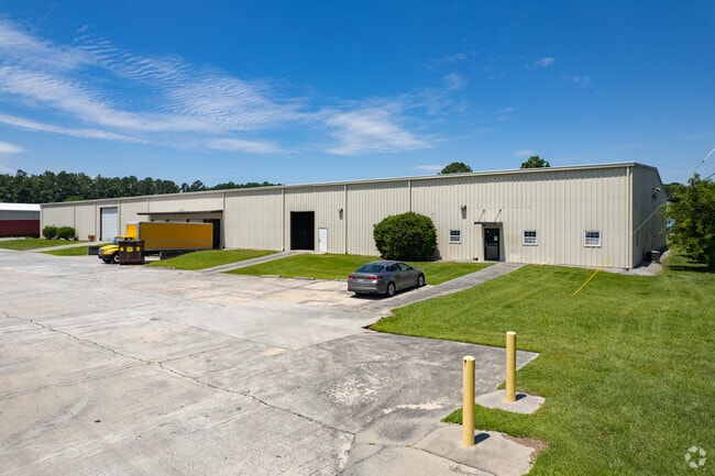
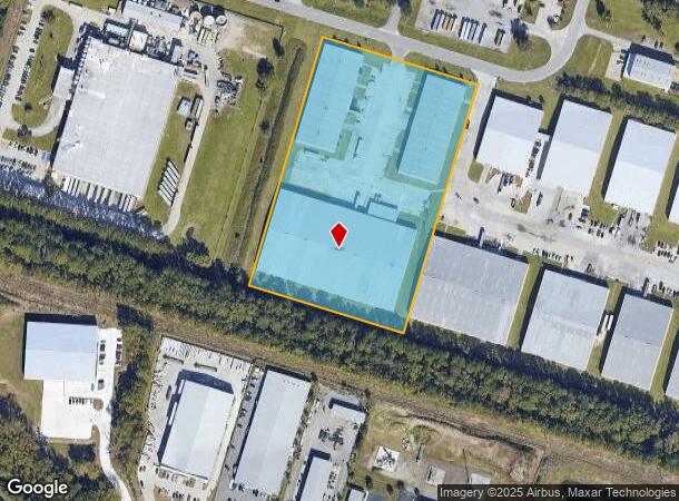
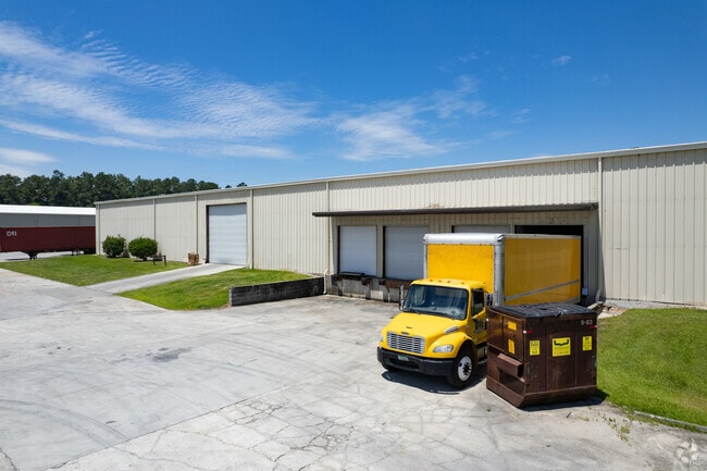
Property Record
25 Artley Rd, Savannah, GA 31408

NEARBY LISTINGS FOR SALE OR LEASE
Property Detail
25 Artley Rd
Savannah, GA
Rial Park Sub
2098504040
Chatham
Condominium
Georgia
X
8.64 AC
13051C0126H
Bloomingdale/Pooler
2,700 SF
Savannah
DEMOGRAPHICS near 25 Artley Rd
1 Mile
3 Mile
5 Mile
2024 Total Population
26
15,168
64,071
2029 Population
27
15,738
67,108
Pop Growth 2024-2029
+ 3.85%
+ 3.76%
+ 4.74%
Average Age
44
40
38
2024 Total Households
10
6,061
24,775
HH Growth 2024-2029
+ 10.00%
+ 3.96%
+ 4.91%
Median Household Inc
$47,500
$69,272
$73,719
Avg Household Size
2.10
2.40
2.40
2024 Avg HH Vehicles
2.00
2.00
2.00
Median Home Value
$99,999
$192,229
$229,910
Median Year Built
1977
1999
2004
Nearby Places
- Restaurants
- Banks
- Shops
- Fitness
- Groceries
PUBLIC TRANSPORTATION
COMMUTER RAIL
Savannah (Palmetto - Amtrak, Silver Meteor - Amtrak, Silver Star - Amtrak)
DRIVE
WALK
Distance
Savannah (Palmetto - Amtrak, Silver Meteor - Amtrak, Silver Star - Amtrak)
16 min
7.1 mi
AIRPORT
Savannah/Hilton Head International
DRIVE
WALK
Distance
Savannah/Hilton Head International
15 min
6.0 mi
Freight Ports
Georgia Ports - Savannah
DRIVE
WALK
Distance
Georgia Ports - Savannah
18 min
8.1 mi
SALE & LEASE HISTORY
LISTING DATE
SALE/LEASE

Oct 20, 2020
For Lease
Oct 06, 2020
For Lease
Nearby Properties
Address
Land Use
TOTAL SIZE
Lot Size
Zoning
Address
Land Use
TOTAL SIZE
Lot Size
Zoning
426,547 SF
15.29 AC
Address
Land Use
TOTAL SIZE
Lot Size
Zoning
432,965 SF
10.09 AC
Address
Land Use
TOTAL SIZE
Lot Size
Zoning
605,200 SF
59.62 AC
I-H
Address
Land Use
TOTAL SIZE
Lot Size
Zoning
17,400 SF
19.34 AC
Address
Land Use
TOTAL SIZE
Lot Size
Zoning
42,338 SF
65.96 AC
PUD
Address
Land Use
TOTAL SIZE
Lot Size
Zoning
3,515 SF
61.21 AC
I1
Address
Land Use
TOTAL SIZE
Lot Size
Zoning
588,726 SF
0.30 AC
I-L
Address
Land Use
TOTAL SIZE
Lot Size
Zoning
944,260 SF
56.31 AC
I-1
Address
Land Use
TOTAL SIZE
Lot Size
Zoning
754,000 SF
63.38 AC
I-H
Address
Land Use
TOTAL SIZE
Lot Size
Zoning
710,881 SF
44.98 AC
I-1
Address
Land Use
TOTAL SIZE
Lot Size
Zoning
691,228 SF
48.27 AC
I-1
Address
Land Use
TOTAL SIZE
Lot Size
Zoning
9,505 SF
0.07 AC
Address
Land Use
TOTAL SIZE
Lot Size
Zoning
547,528 SF
67.26 AC
I-1
Address
Land Use
TOTAL SIZE
Lot Size
Zoning
285,905 SF
20.16 AC
I-L
Address
Land Use
TOTAL SIZE
Lot Size
Zoning
109,284 SF
24.54 AC
R-3-B
Address
Land Use
TOTAL SIZE
Lot Size
Zoning
670,800 SF
43.38 AC
I-H
Address
Land Use
TOTAL SIZE
Lot Size
Zoning
3,648 SF
66.30 AC
I-L
Address
Land Use
TOTAL SIZE
Lot Size
Zoning
499,500 SF
28.53 AC
Address
Land Use
TOTAL SIZE
Lot Size
Zoning
408 SF
47.25 AC
I-H
Address
Land Use
TOTAL SIZE
Lot Size
Zoning
985.60 AC
I-2
Address
Land Use
TOTAL SIZE
Lot Size
Zoning
34,404 SF
20 AC
C2
Address
Land Use
TOTAL SIZE
Lot Size
Zoning
15,804 SF
17 AC
R3
Address
Land Use
TOTAL SIZE
Lot Size
Zoning
495,600 SF
35.64 AC
I-H
Address
Land Use
TOTAL SIZE
Lot Size
Zoning
392,099 SF
20 AC
I-H
Address
Land Use
TOTAL SIZE
Lot Size
Zoning
12,150 SF
23.76 AC
Address
Land Use
TOTAL SIZE
Lot Size
Zoning
18,483 SF
71.98 AC
Address
Land Use
TOTAL SIZE
Lot Size
Zoning
500 SF
24.13 AC
I-1
Address
Land Use
TOTAL SIZE
Lot Size
Zoning
521,740 SF
230.25 AC
I-1
Address
Land Use
TOTAL SIZE
Lot Size
Zoning
22,472 SF
15.09 AC
PUD-M8
Address
Land Use
TOTAL SIZE
Lot Size
Zoning
12,025 SF
13.23 AC
PUD
The World's #1 Commercial Real Estate Marketplace
Connect with us
© 2025 CoStar Group
The information above has been obtained from sources believed reliable. While we do not doubt its accuracy we have not verified it and make no guarantee, warranty or representation about it. It is your responsibility to independently confirm its accuracy and completeness. Any projections, opinions, assumptions, or estimates used are for example only and do not represent the current or future performance of the property. The value of this transaction to you depends on tax and other factors which should be evaluated by your tax, financial, and legal advisors. You and your advisors should conduct a careful, independent investigation of the property to determine to your satisfaction the suitability of the property for your needs.