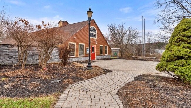
Property Record
26 Benton Rd, Amenia, NY 12501

Current Lease Availabilities
NEARBY LISTINGS FOR SALE OR LEASE
-
-
View all Amenia listings for lease on LoopNet.com
Property Detail
26 Benton Rd
Dutchess County-Putnam County, NY
Dutchess
132000-7164-00-602734-0000
New York
Communitycenter
602
0
26.33 AC
2024
Fishkill
010000
Westchester/So Connecticut
6,966 SF
DEMOGRAPHICS near 26 Benton Rd
1 Mile
3 Mile
5 Mile
2024 Total Population
382
3,076
7,294
2029 Population
387
3,129
7,420
Pop Growth 2024-2029
+ 1.31%
+ 1.72%
+ 1.73%
Average Age
45
46
45
2024 Total Households
156
1,311
3,075
HH Growth 2024-2029
+ 1.28%
+ 1.91%
+ 1.92%
Median Household Inc
$69,473
$74,602
$79,064
Avg Household Size
2.30
2.30
2.30
2024 Avg HH Vehicles
2.00
2.00
2.00
Median Home Value
$381,249
$296,820
$320,292
Median Year Built
1967
1964
1965
Nearby Places
Map Layers
Map Styles
 Street
 Aerial
- Restaurants
- Banks
- Shops
- Fitness
- Groceries
PUBLIC TRANSPORTATION
COMMUTER RAIL
Tenmile River Station (Harlem Line - Metro-North Commuter Railroad Company (Metro-North))
DRIVE
WALK
Distance
Tenmile River Station (Harlem Line - Metro-North Commuter Railroad Company (Metro-North))
2 min
1.1 mi
Dover Plains Station (Harlem Line - Metro-North Commuter Railroad Company (Metro-North))
DRIVE
WALK
Distance
Dover Plains Station (Harlem Line - Metro-North Commuter Railroad Company (Metro-North))
7 min
4.1 mi
Freight Ports
Port of New Haven
DRIVE
WALK
Distance
Port of New Haven
101 min
62.8 mi
Nearby Properties
Address
Land Use
TOTAL SIZE
Lot Size
Zoning
Address
Land Use
TOTAL SIZE
Lot Size
Zoning
2,000 SF
85.70 AC
RA
Address
Land Use
TOTAL SIZE
Lot Size
Zoning
12,801 SF
165.42 AC
RA
Address
Land Use
TOTAL SIZE
Lot Size
Zoning
103,750 SF
7.19 AC
HM
Address
Land Use
TOTAL SIZE
Lot Size
Zoning
3.57 AC
HR
Address
Land Use
TOTAL SIZE
Lot Size
Zoning
332.30 AC
RR10
Address
Land Use
TOTAL SIZE
Lot Size
Zoning
Address
Land Use
TOTAL SIZE
Lot Size
Zoning
5,111 SF
36.25 AC
RR10
Address
Land Use
TOTAL SIZE
Lot Size
Zoning
904 AC
Address
Land Use
TOTAL SIZE
Lot Size
Zoning
2,074 SF
9.22 AC
HR
Address
Land Use
TOTAL SIZE
Lot Size
Zoning
4,108 SF
32.35 AC
RR
Address
Land Use
TOTAL SIZE
Lot Size
Zoning
5,330 SF
204 AC
RA-RR
Address
Land Use
TOTAL SIZE
Lot Size
Zoning
5,268 SF
173.30 AC
RA-RR
Address
Land Use
TOTAL SIZE
Lot Size
Zoning
5,418 SF
6 AC
SR
Address
Land Use
TOTAL SIZE
Lot Size
Zoning
143.91 AC
HR
Address
Land Use
TOTAL SIZE
Lot Size
Zoning
138.84 AC
RA
Address
Land Use
TOTAL SIZE
Lot Size
Zoning
11,240 SF
1.60 AC
RH1
Address
Land Use
TOTAL SIZE
Lot Size
Zoning
20,000 SF
3.50 AC
OC
Address
Land Use
TOTAL SIZE
Lot Size
Zoning
140.10 AC
RR
Address
Land Use
TOTAL SIZE
Lot Size
Zoning
7,680 SF
18.90 AC
RA
Address
Land Use
TOTAL SIZE
Lot Size
Zoning
65.78 AC
RA
Address
Land Use
TOTAL SIZE
Lot Size
Zoning
63.32 AC
RR10
Address
Land Use
TOTAL SIZE
Lot Size
Zoning
10.49 AC
RR
Address
Land Use
TOTAL SIZE
Lot Size
Zoning
168.40 AC
RA
Address
Land Use
TOTAL SIZE
Lot Size
Zoning
82.60 AC
RA
Address
Land Use
TOTAL SIZE
Lot Size
Zoning
4,116 SF
63.07 AC
RR10
Address
Land Use
TOTAL SIZE
Lot Size
Zoning
1,482 SF
88.46 AC
RR10
Address
Land Use
TOTAL SIZE
Lot Size
Zoning
420.90 AC
RA
Address
Land Use
TOTAL SIZE
Lot Size
Zoning
2,880 SF
51.99 AC
RA-OC
Address
Land Use
TOTAL SIZE
Lot Size
Zoning
6,892 SF
72 AC
RR
The World's #1 Commercial Real Estate Marketplace
Connect with us
© 2026 CoStar Group
The information above has been obtained from sources believed reliable. While we do not doubt its accuracy we have not verified it and make no guarantee, warranty or representation about it. It is your responsibility to independently confirm its accuracy and completeness. Any projections, opinions, assumptions, or estimates used are for example only and do not represent the current or future performance of the property. The value of this transaction to you depends on tax and other factors which should be evaluated by your tax, financial, and legal advisors. You and your advisors should conduct a careful, independent investigation of the property to determine to your satisfaction the suitability of the property for your needs.