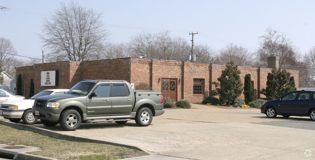
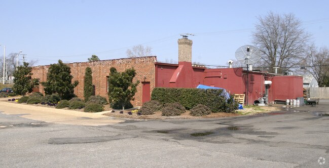
Property Record
26 E Mercury Blvd, Hampton, VA 23669

Property Detail
26 E Mercury Blvd
8001172
26 E MERCURY BLVD PCF 1.2088AC
Restaurantbuilding
Hampton City
13 C-1 NEI
Virginia
C and X Area of minimal flood hazard, usually depicted on FIRMs as above the 500-year flood level.
1.21 AC
2025
Fox Hill
2025
Hampton Roads
010602
Virginia Beach-Chesapeake-Norfolk, VA-NC
6,344 SF
NEARBY LISTINGS FOR SALE OR LEASE
DEMOGRAPHICS near 26 E Mercury Blvd
1 mile
3 mile
5 mile
2025 Total Population
11,295
80,666
135,205
2030 Population
11,199
80,421
135,303
Pop Growth 2025-2030
(0.85%)
(0.30%)
+ 0.07%
Average Age
39
39
39
2025 Total Households
4,926
33,475
57,024
HH Growth 2025-2030
(0.93%)
(0.34%)
+ 0.06%
Median Household Inc
$56,469
$68,850
$69,742
Avg Household Size
2.30
2.30
2.30
2025 Avg HH Vehicles
2.00
2.00
2.00
Median Home Value
$204,441
$243,071
$244,818
Median Year Built
1969
1972
1973
Nearby Places
Map Layers
Map Styles
 Street
 Aerial
Transit
 Traffic
 Biking
Places
Listings with unknown addresses are not visible on the map
- Restaurants
- Banks
- Shops
- Fitness
- Groceries
Nearby Properties
Address
Land Use
TOTAL SIZE
Lot Size
Zoning
Address
Land Use
TOTAL SIZE
Lot Size
Zoning
2,500 SF
2,882 AC
5 R-13 ONE
Address
Land Use
TOTAL SIZE
Lot Size
Zoning
1 SF
92.67 AC
5 R-13 ONE
Address
Land Use
TOTAL SIZE
Lot Size
Zoning
83.50 AC
5 R-13 ONE
Address
Land Use
TOTAL SIZE
Lot Size
Zoning
347,560 SF
31.84 AC
14 C-2 LIM
Address
Land Use
TOTAL SIZE
Lot Size
Zoning
249,628 SF
52.71 AC
14 C-2 LIM
Address
Land Use
TOTAL SIZE
Lot Size
Zoning
112,089 SF
11.95 AC
30 DT-3 DO
Address
Land Use
TOTAL SIZE
Lot Size
Zoning
199,364 SF
22.12 AC
6 R-11 ONE
Address
Land Use
TOTAL SIZE
Lot Size
Zoning
45,076 SF
9.53 AC
11 MD-4 MU
Address
Land Use
TOTAL SIZE
Lot Size
Zoning
19,328 SF
15.14 AC
14 C-2 LIM
Address
Land Use
TOTAL SIZE
Lot Size
Zoning
204,584 SF
34.79 AC
6 R-11 ONE
Address
Land Use
TOTAL SIZE
Lot Size
Zoning
240,000 SF
30.38 AC
7 R-9 ONE
Address
Land Use
TOTAL SIZE
Lot Size
Zoning
248,956 SF
12.80 AC
14 C-2 LIM
Address
Land Use
TOTAL SIZE
Lot Size
Zoning
230,974 SF
42.68 AC
5 R-13 ONE
Address
Land Use
TOTAL SIZE
Lot Size
Zoning
88,941 SF
29.32 AC
11 MD-4 MU
Address
Land Use
TOTAL SIZE
Lot Size
Zoning
17,368 SF
7.08 AC
11 MD-4 MU
Address
Land Use
TOTAL SIZE
Lot Size
Zoning
7,053 SF
12.28 AC
14 C-2 LIM
Address
Land Use
TOTAL SIZE
Lot Size
Zoning
7,720 SF
9.91 AC
14 C-2 LIM
Address
Land Use
TOTAL SIZE
Lot Size
Zoning
286,173 SF
10 AC
14 C-2 LIM
Address
Land Use
TOTAL SIZE
Lot Size
Zoning
34,222 SF
2.11 AC
14 C-2 LIM
Address
Land Use
TOTAL SIZE
Lot Size
Zoning
355,300 SF
19.03 AC
9 R-M MULT
Address
Land Use
TOTAL SIZE
Lot Size
Zoning
73,668 SF
3.24 AC
30 DT-3 DO
Address
Land Use
TOTAL SIZE
Lot Size
Zoning
51,372 SF
5.99 AC
14 C-2 LIM
Address
Land Use
TOTAL SIZE
Lot Size
Zoning
110,080 SF
2.21 AC
29 DT-2 DO
Address
Land Use
TOTAL SIZE
Lot Size
Zoning
168,850 SF
1.02 AC
14 C-2 LIM
Address
Land Use
TOTAL SIZE
Lot Size
Zoning
7,840 SF
19.66 AC
9 R-M MULT
Address
Land Use
TOTAL SIZE
Lot Size
Zoning
4.99 AC
47 PH-2 PH
Address
Land Use
TOTAL SIZE
Lot Size
Zoning
212,766 SF
9.54 AC
13 C-1 NEI
Address
Land Use
TOTAL SIZE
Lot Size
Zoning
71,677 SF
18.59 AC
14 C-2 LIM
Address
Land Use
TOTAL SIZE
Lot Size
Zoning
114,040 SF
1.46 AC
28 DT-1 DO
Address
Land Use
TOTAL SIZE
Lot Size
Zoning
140,649 SF
25.29 AC
7 R-9 ONE
The World's #1 Commercial Real Estate Marketplace
Connect with us
© 2026 CoStar Group
The information above has been obtained from sources believed reliable. While we do not doubt its accuracy we have not verified it and make no guarantee, warranty or representation about it. It is your responsibility to independently confirm its accuracy and completeness. Any projections, opinions, assumptions, or estimates used are for example only and do not represent the current or future performance of the property. The value of this transaction to you depends on tax and other factors which should be evaluated by your tax, financial, and legal advisors. You and your advisors should conduct a careful, independent investigation of the property to determine to your satisfaction the suitability of the property for your needs.