Property Record
26 Middleton Rd, Wolfeboro, NH 03894
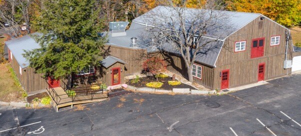

Property Detail
26 Middleton Rd
Multifamilydwelling
CARROLL
RUST P
New Hampshire
AE The base floodplain where base flood elevations are provided. AE Zones are now used on new format FIRMs instead of A1-A30 Zones.
2.75 AC
2025
Concord/New Hampshire North Area
2025
Other Market Areas
956102
WOLF-000260-000077
4,639 SF
NEARBY LISTINGS FOR SALE OR LEASE
-
-
View all Wolfeboro listings for sale on LoopNet.com
DEMOGRAPHICS near 26 Middleton Rd
1 mile
3 mile
5 mile
2025 Total Population
699
3,526
7,638
2030 Population
716
3,643
7,846
Pop Growth 2025-2030
+ 2.43%
+ 3.32%
+ 2.72%
Average Age
50
50
50
2025 Total Households
279
1,518
3,389
HH Growth 2025-2030
+ 2.51%
+ 3.43%
+ 2.77%
Median Household Inc
$129,028
$104,432
$97,211
Avg Household Size
2.40
2.20
2.20
2025 Avg HH Vehicles
2.00
2.00
2.00
Median Home Value
$578,125
$578,234
$555,740
Median Year Built
1982
1981
1981
Nearby Places
Map Layers
Map Styles
 Street
 Aerial
Layers
 Traffic
 Biking
Places
Listings with unknown addresses are not visible on the map
- Restaurants
- Banks
- Shops
- Fitness
- Groceries
SALE & LEASE HISTORY
LISTING DATE
SALE/LEASE

Sep 24, 2016
For Sale
Sep 09, 2021
For Sale
Oct 26, 2018
For Sale
Mar 28, 2017
For Sale
Nearby Properties
Address
Land Use
TOTAL SIZE
Lot Size
Zoning
Address
Land Use
TOTAL SIZE
Lot Size
Zoning
53,306 SF
65.72 AC
WINNIP
Address
Land Use
TOTAL SIZE
Lot Size
Zoning
306,273 SF
46.12 AC
COMMER
Address
Land Use
TOTAL SIZE
Lot Size
Zoning
17.55 AC
COMMER
Address
Land Use
TOTAL SIZE
Lot Size
Zoning
1,789 SF
30.81 AC
COMMER
Address
Land Use
TOTAL SIZE
Lot Size
Zoning
17,788 SF
7.10 AC
WINNIP
Address
Land Use
TOTAL SIZE
Lot Size
Zoning
13,330 SF
50.21 AC
LAKE W
Address
Land Use
TOTAL SIZE
Lot Size
Zoning
13,445 SF
2.42 AC
WINNIP
Address
Land Use
TOTAL SIZE
Lot Size
Zoning
10,729 SF
61.40 AC
SOUTH
Address
Land Use
TOTAL SIZE
Lot Size
Zoning
11,121 SF
1.24 AC
WINNIP
Address
Land Use
TOTAL SIZE
Lot Size
Zoning
40,404 SF
2.52 AC
WINNIP
Address
Land Use
TOTAL SIZE
Lot Size
Zoning
8,535 SF
1.94 AC
WINNIP
Address
Land Use
TOTAL SIZE
Lot Size
Zoning
8,058 SF
1.95 AC
WINNIP
Address
Land Use
TOTAL SIZE
Lot Size
Zoning
7,491 SF
3.45 AC
WINNIP
Address
Land Use
TOTAL SIZE
Lot Size
Zoning
2,336 SF
2.12 AC
WINNIP
Address
Land Use
TOTAL SIZE
Lot Size
Zoning
7,873 SF
15.75 AC
WINNIP
Address
Land Use
TOTAL SIZE
Lot Size
Zoning
6,302 SF
7.71 AC
WINNIP
Address
Land Use
TOTAL SIZE
Lot Size
Zoning
7,558 SF
7.30 AC
CRESCE
Address
Land Use
TOTAL SIZE
Lot Size
Zoning
6,616 SF
3.60 AC
WINNIP
Address
Land Use
TOTAL SIZE
Lot Size
Zoning
1.28 AC
WINNIP
Address
Land Use
TOTAL SIZE
Lot Size
Zoning
6,973 SF
14.62 AC
LR-LAK
Address
Land Use
TOTAL SIZE
Lot Size
Zoning
29,560 SF
9.48 AC
LR-LAK
Address
Land Use
TOTAL SIZE
Lot Size
Zoning
3,935 SF
5.97 AC
WINNIP
Address
Land Use
TOTAL SIZE
Lot Size
Zoning
4,084 SF
1.43 AC
WINNIP
Address
Land Use
TOTAL SIZE
Lot Size
Zoning
2,124 SF
11.30 AC
LR-LAK
Address
Land Use
TOTAL SIZE
Lot Size
Zoning
1,800 SF
19.50 AC
LAKE W
Address
Land Use
TOTAL SIZE
Lot Size
Zoning
43,609 SF
15.30 AC
SOUTH
Address
Land Use
TOTAL SIZE
Lot Size
Zoning
44,904 SF
0.21 AC
VILLAG
Address
Land Use
TOTAL SIZE
Lot Size
Zoning
7,763 SF
1.24 AC
LR-LAK
Address
Land Use
TOTAL SIZE
Lot Size
Zoning
6,206 SF
7.31 AC
LR-LAK
Address
Land Use
TOTAL SIZE
Lot Size
Zoning
21,729 SF
6.14 AC
COMMER
The World's #1 Commercial Real Estate Marketplace
Connect with us
© 2026 CoStar Group
The information above has been obtained from sources believed reliable. While we do not doubt its accuracy we have not verified it and make no guarantee, warranty or representation about it. It is your responsibility to independently confirm its accuracy and completeness. Any projections, opinions, assumptions, or estimates used are for example only and do not represent the current or future performance of the property. The value of this transaction to you depends on tax and other factors which should be evaluated by your tax, financial, and legal advisors. You and your advisors should conduct a careful, independent investigation of the property to determine to your satisfaction the suitability of the property for your needs.