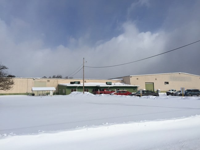
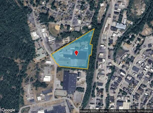
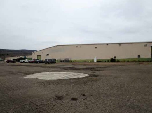
Property Record
26 N Scott St, Carbondale, PA 18407
NEARBY LISTINGS FOR SALE OR LEASE
-
-
View all Carbondale listings for sale on LoopNet.com
Property Detail
26 N Scott St
Scranton--Wilkes-Barre--Hazelton, PA
11.7A W-01 B-006 L-045
04404020003
Lackawanna
Industrialgeneral
Pennsylvania
X
45
42069C0134D
11.70 AC
2025
I-81 Corridor
2025
Philadelphia
110700
DEMOGRAPHICS near 26 N Scott St
1 Mile
3 Mile
5 Mile
2024 Total Population
8,462
12,620
20,838
2029 Population
8,405
12,552
20,674
Pop Growth 2024-2029
(0.67%)
(0.54%)
(0.79%)
Average Age
41
42
42
2024 Total Households
3,591
5,338
8,654
HH Growth 2024-2029
(0.72%)
(0.56%)
(0.81%)
Median Household Inc
$50,421
$55,373
$60,923
Avg Household Size
2.20
2.30
2.30
2024 Avg HH Vehicles
1.00
2.00
2.00
Median Home Value
$115,439
$130,798
$151,933
Median Year Built
1948
1951
1955
Nearby Places
Map Layers
Map Styles
 Street
 Aerial
- Restaurants
- Banks
- Shops
- Fitness
- Groceries
PUBLIC TRANSPORTATION
AIRPORT
Wilkes-Barre/Scranton International
DRIVE
WALK
Distance
Wilkes-Barre/Scranton International
39 min
25.3 mi
Freight Ports
Maher Terminal
DRIVE
WALK
Distance
Maher Terminal
161 min
125.9 mi
Nearby Properties
Address
Land Use
TOTAL SIZE
Lot Size
Zoning
Address
Land Use
TOTAL SIZE
Lot Size
Zoning
1.19 AC
Address
Land Use
TOTAL SIZE
Lot Size
Zoning
15.04 AC
Address
Land Use
TOTAL SIZE
Lot Size
Zoning
11.70 AC
Address
Land Use
TOTAL SIZE
Lot Size
Zoning
Address
Land Use
TOTAL SIZE
Lot Size
Zoning
18.56 AC
Address
Land Use
TOTAL SIZE
Lot Size
Zoning
Address
Land Use
TOTAL SIZE
Lot Size
Zoning
11.67 AC
Address
Land Use
TOTAL SIZE
Lot Size
Zoning
Address
Land Use
TOTAL SIZE
Lot Size
Zoning
12.02 AC
Address
Land Use
TOTAL SIZE
Lot Size
Zoning
0.57 AC
Address
Land Use
TOTAL SIZE
Lot Size
Zoning
2.89 AC
Address
Land Use
TOTAL SIZE
Lot Size
Zoning
Address
Land Use
TOTAL SIZE
Lot Size
Zoning
1,072 SF
84.50 AC
Address
Land Use
TOTAL SIZE
Lot Size
Zoning
16.80 AC
Address
Land Use
TOTAL SIZE
Lot Size
Zoning
11.08 AC
Address
Land Use
TOTAL SIZE
Lot Size
Zoning
3.79 AC
Address
Land Use
TOTAL SIZE
Lot Size
Zoning
2.03 AC
Address
Land Use
TOTAL SIZE
Lot Size
Zoning
0.18 AC
Address
Land Use
TOTAL SIZE
Lot Size
Zoning
12.76 AC
Address
Land Use
TOTAL SIZE
Lot Size
Zoning
1,652 SF
1.78 AC
Address
Land Use
TOTAL SIZE
Lot Size
Zoning
3.93 AC
Address
Land Use
TOTAL SIZE
Lot Size
Zoning
13.38 AC
Address
Land Use
TOTAL SIZE
Lot Size
Zoning
4.62 AC
Address
Land Use
TOTAL SIZE
Lot Size
Zoning
1.28 AC
Address
Land Use
TOTAL SIZE
Lot Size
Zoning
0.41 AC
Address
Land Use
TOTAL SIZE
Lot Size
Zoning
1.22 AC
Address
Land Use
TOTAL SIZE
Lot Size
Zoning
Address
Land Use
TOTAL SIZE
Lot Size
Zoning
Address
Land Use
TOTAL SIZE
Lot Size
Zoning
0.31 AC
Address
Land Use
TOTAL SIZE
Lot Size
Zoning
1.54 AC
The World's #1 Commercial Real Estate Marketplace
Connect with us
© 2026 CoStar Group
The information above has been obtained from sources believed reliable. While we do not doubt its accuracy we have not verified it and make no guarantee, warranty or representation about it. It is your responsibility to independently confirm its accuracy and completeness. Any projections, opinions, assumptions, or estimates used are for example only and do not represent the current or future performance of the property. The value of this transaction to you depends on tax and other factors which should be evaluated by your tax, financial, and legal advisors. You and your advisors should conduct a careful, independent investigation of the property to determine to your satisfaction the suitability of the property for your needs.