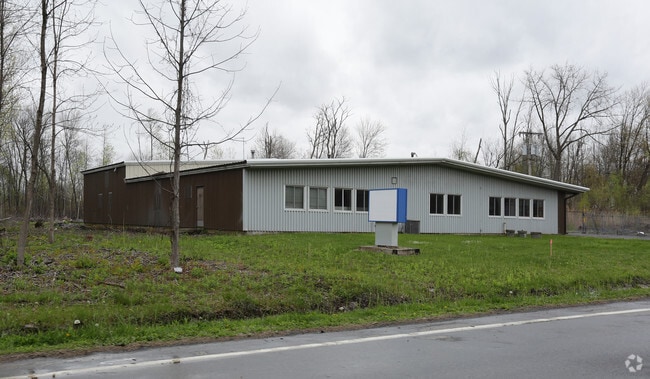
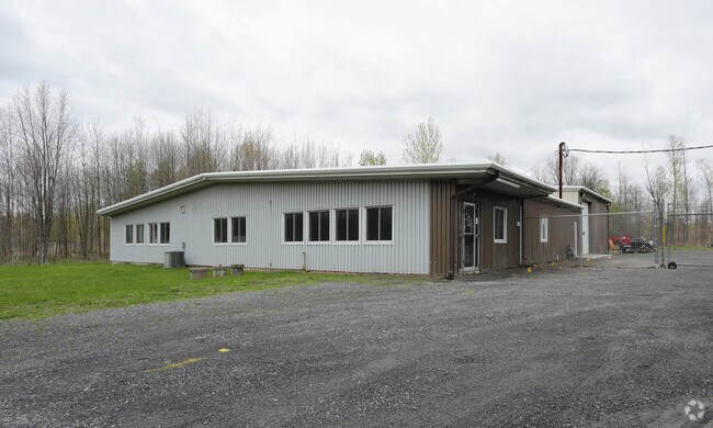
Property Record
26 Sicker Rd, Latham, NY 12110

Property Detail
26 Sicker Rd
012689-018-000-0002-044-000-0000
N-14 E-30 C-36-62
Warehouse
Albany
17
New York
B and X Area of moderate flood hazard, usually the area between the limits of the 100-year and 500-year floods.
44.000
2025
1 AC
2025
E Outer Albany County
013703
Albany/Schenectady/Troy
8,080 SF
Albany-Schenectady-Troy, NY
NEARBY LISTINGS FOR SALE OR LEASE
DEMOGRAPHICS near 26 Sicker Rd
1 mile
3 mile
5 mile
2025 Total Population
1,006
32,537
113,051
2030 Population
1,046
33,045
114,802
Pop Growth 2025-2030
+ 3.98%
+ 1.56%
+ 1.55%
Average Age
46
43
42
2025 Total Households
309
12,955
44,306
HH Growth 2025-2030
+ 4.53%
+ 1.63%
+ 1.67%
Median Household Inc
$107,670
$101,709
$99,991
Avg Household Size
2.50
2.40
2.30
2025 Avg HH Vehicles
2.00
2.00
2.00
Median Home Value
$353,669
$336,393
$320,691
Median Year Built
1973
1974
1974
Nearby Places
Map Layers
Map Styles
 Street
 Aerial
Layers
 Traffic
 Biking
Places
Listings with unknown addresses are not visible on the map
- Restaurants
- Banks
- Shops
- Fitness
- Groceries
PUBLIC TRANSPORTATION
AIRPORT
Albany International
Drive
Walk
Distance
Albany International
6 min
2.7 mi
SALE & LEASE HISTORY
LISTING DATE
SALE/LEASE

Sep 25, 2016
For Lease
Nearby Properties
Address
Land Use
TOTAL SIZE
Lot Size
Zoning
Address
Land Use
TOTAL SIZE
Lot Size
Zoning
821,670 SF
803.50 AC
17
Address
Land Use
TOTAL SIZE
Lot Size
Zoning
154,580 SF
89.34 AC
16
Address
Land Use
TOTAL SIZE
Lot Size
Zoning
242,658 SF
29 AC
19
Address
Land Use
TOTAL SIZE
Lot Size
Zoning
90,316 SF
57.10 AC
04 - FARM
Address
Land Use
TOTAL SIZE
Lot Size
Zoning
226,171 SF
26.39 AC
12
Address
Land Use
TOTAL SIZE
Lot Size
Zoning
301,834 SF
9 AC
26
Address
Land Use
TOTAL SIZE
Lot Size
Zoning
266,600 SF
22.60 AC
47
Address
Land Use
TOTAL SIZE
Lot Size
Zoning
242,630 SF
18.50 AC
16
Address
Land Use
TOTAL SIZE
Lot Size
Zoning
84,242 SF
43.60 AC
12
Address
Land Use
TOTAL SIZE
Lot Size
Zoning
25,786 SF
8 AC
17
Address
Land Use
TOTAL SIZE
Lot Size
Zoning
8,084 SF
36.30 AC
25
Address
Land Use
TOTAL SIZE
Lot Size
Zoning
167,222 SF
15.65 AC
14
Address
Land Use
TOTAL SIZE
Lot Size
Zoning
162,500 SF
19.90 AC
17
Address
Land Use
TOTAL SIZE
Lot Size
Zoning
256,101 SF
9 AC
12
Address
Land Use
TOTAL SIZE
Lot Size
Zoning
141,570 SF
4.43 AC
12
Address
Land Use
TOTAL SIZE
Lot Size
Zoning
264,473 SF
26.40 AC
25
Address
Land Use
TOTAL SIZE
Lot Size
Zoning
83,120 SF
126.75 AC
25
Address
Land Use
TOTAL SIZE
Lot Size
Zoning
73,736 SF
7.58 AC
14
Address
Land Use
TOTAL SIZE
Lot Size
Zoning
214,716 SF
28.40 AC
19
Address
Land Use
TOTAL SIZE
Lot Size
Zoning
9,774 SF
49.20 AC
43
Address
Land Use
TOTAL SIZE
Lot Size
Zoning
53,852 SF
43.35 AC
25
Address
Land Use
TOTAL SIZE
Lot Size
Zoning
25,112 SF
13.16 AC
04 - FARM
Address
Land Use
TOTAL SIZE
Lot Size
Zoning
Address
Land Use
TOTAL SIZE
Lot Size
Zoning
10,088 SF
30.04 AC
08 - GOVER
Address
Land Use
TOTAL SIZE
Lot Size
Zoning
269,318 SF
7.60 AC
17
Address
Land Use
TOTAL SIZE
Lot Size
Zoning
186,095 SF
14.94 AC
12
Address
Land Use
TOTAL SIZE
Lot Size
Zoning
117,723 SF
9.07 AC
12
Address
Land Use
TOTAL SIZE
Lot Size
Zoning
99,620 SF
15 AC
45
Address
Land Use
TOTAL SIZE
Lot Size
Zoning
151,287 SF
11.20 AC
12
Address
Land Use
TOTAL SIZE
Lot Size
Zoning
106,723 SF
4.73 AC
12
The World's #1 Commercial Real Estate Marketplace
Connect with us
© 2026 CoStar Group
The information above has been obtained from sources believed reliable. While we do not doubt its accuracy we have not verified it and make no guarantee, warranty or representation about it. It is your responsibility to independently confirm its accuracy and completeness. Any projections, opinions, assumptions, or estimates used are for example only and do not represent the current or future performance of the property. The value of this transaction to you depends on tax and other factors which should be evaluated by your tax, financial, and legal advisors. You and your advisors should conduct a careful, independent investigation of the property to determine to your satisfaction the suitability of the property for your needs.