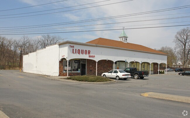
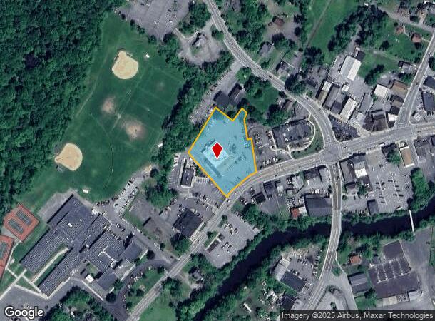
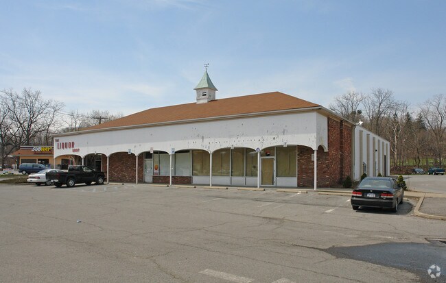
Property Record
26 W Main St, Goshen, NY 10924
NEARBY LISTINGS FOR SALE OR LEASE
Property Detail
26 W Main St
332001-112-000-0004-017.112-0000
Orange
Commercialnec
New York
AE
17.11
36071C0316E
1.40 AC
2024
Newburgh
2024
Northern New Jersey
012100
New York-Jersey City-White Plains, NY-NJ
9,873 SF
DEMOGRAPHICS near 26 W Main St
1 Mile
3 Mile
5 Mile
2024 Total Population
4,408
15,352
34,684
2029 Population
4,512
15,668
35,423
Pop Growth 2024-2029
+ 2.36%
+ 2.06%
+ 2.13%
Average Age
43
41
39
2024 Total Households
1,726
5,362
11,502
HH Growth 2024-2029
+ 2.32%
+ 2.16%
+ 2.20%
Median Household Inc
$78,829
$103,328
$106,589
Avg Household Size
2.50
2.80
2.90
2024 Avg HH Vehicles
2.00
2.00
2.00
Median Home Value
$306,846
$339,444
$363,000
Median Year Built
1983
1980
1978
Nearby Places
- Restaurants
- Banks
- Shops
- Fitness
- Groceries
PUBLIC TRANSPORTATION
COMMUTER RAIL
Salisbury Mills Cornwall (Bergen County/Port Jervis Line - NJ Transit Commuter Rail (NJ Transit), Main/Port Jervis Line - NJ Transit Commuter Rail (NJ Transit))
DRIVE
WALK
Distance
Salisbury Mills Cornwall (Bergen County/Port Jervis Line - NJ Transit Commuter Rail (NJ Transit), Main/Port Jervis Line - NJ Transit Commuter Rail (NJ Transit))
9 min
3.8 mi
Campbell Hall (Bergen County/Port Jervis Line - NJ Transit Commuter Rail (NJ Transit), Main/Port Jervis Line - NJ Transit Commuter Rail (NJ Transit))
DRIVE
WALK
Distance
Campbell Hall (Bergen County/Port Jervis Line - NJ Transit Commuter Rail (NJ Transit), Main/Port Jervis Line - NJ Transit Commuter Rail (NJ Transit))
16 min
8.7 mi
AIRPORT
New York Stewart International
DRIVE
WALK
Distance
New York Stewart International
17 min
7.7 mi
Nearby Properties
Address
Land Use
TOTAL SIZE
Lot Size
Zoning
Address
Land Use
TOTAL SIZE
Lot Size
Zoning
Address
Land Use
TOTAL SIZE
Lot Size
Zoning
Address
Land Use
TOTAL SIZE
Lot Size
Zoning
Address
Land Use
TOTAL SIZE
Lot Size
Zoning
6,048 SF
145.80 AC
R4A
Address
Land Use
TOTAL SIZE
Lot Size
Zoning
117 AC
RR10
Address
Land Use
TOTAL SIZE
Lot Size
Zoning
10,881 SF
182.10 AC
Address
Land Use
TOTAL SIZE
Lot Size
Zoning
86.58 AC
RS10
Address
Land Use
TOTAL SIZE
Lot Size
Zoning
Address
Land Use
TOTAL SIZE
Lot Size
Zoning
75.20 AC
RR10
Address
Land Use
TOTAL SIZE
Lot Size
Zoning
73.57 AC
RR10
Address
Land Use
TOTAL SIZE
Lot Size
Zoning
82,049 SF
11.10 AC
Address
Land Use
TOTAL SIZE
Lot Size
Zoning
6,542 SF
3 AC
NB*
Address
Land Use
TOTAL SIZE
Lot Size
Zoning
15,806 SF
7 AC
NB*
Address
Land Use
TOTAL SIZE
Lot Size
Zoning
2,433 SF
89.60 AC
R4A*
Address
Land Use
TOTAL SIZE
Lot Size
Zoning
Address
Land Use
TOTAL SIZE
Lot Size
Zoning
5.20 AC
Address
Land Use
TOTAL SIZE
Lot Size
Zoning
Address
Land Use
TOTAL SIZE
Lot Size
Zoning
31.20 AC
R4A
Address
Land Use
TOTAL SIZE
Lot Size
Zoning
2,078 SF
27.40 AC
R4A
Address
Land Use
TOTAL SIZE
Lot Size
Zoning
Address
Land Use
TOTAL SIZE
Lot Size
Zoning
81.50 AC
R4A
Address
Land Use
TOTAL SIZE
Lot Size
Zoning
31,626 SF
228.90 AC
Address
Land Use
TOTAL SIZE
Lot Size
Zoning
13.20 AC
Address
Land Use
TOTAL SIZE
Lot Size
Zoning
Address
Land Use
TOTAL SIZE
Lot Size
Zoning
79.20 AC
R4A
Address
Land Use
TOTAL SIZE
Lot Size
Zoning
3,928 SF
5 AC
R2A
Address
Land Use
TOTAL SIZE
Lot Size
Zoning
7,424 SF
2 AC
R2A*
Address
Land Use
TOTAL SIZE
Lot Size
Zoning
Address
Land Use
TOTAL SIZE
Lot Size
Zoning
169.10 AC
Address
Land Use
TOTAL SIZE
Lot Size
Zoning
The World's #1 Commercial Real Estate Marketplace
Connect with us
© 2025 CoStar Group
The information above has been obtained from sources believed reliable. While we do not doubt its accuracy we have not verified it and make no guarantee, warranty or representation about it. It is your responsibility to independently confirm its accuracy and completeness. Any projections, opinions, assumptions, or estimates used are for example only and do not represent the current or future performance of the property. The value of this transaction to you depends on tax and other factors which should be evaluated by your tax, financial, and legal advisors. You and your advisors should conduct a careful, independent investigation of the property to determine to your satisfaction the suitability of the property for your needs.