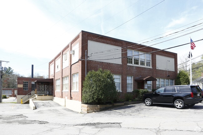
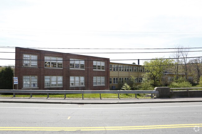
Property Record
26 Wapping Rd, Kingston, MA 02364
Property Detail
26 Wapping Rd
KING-000044-000049
Plymouth
Industrialgeneral
Massachusetts
AE The base floodplain where base flood elevations are provided. AE Zones are now used on new format FIRMs instead of A1-A30 Zones.
4.13 AC
2025
Route 3 South
2025
Boston
509101
Boston-Cambridge-Newton, MA-NH
NEARBY LISTINGS FOR SALE OR LEASE
DEMOGRAPHICS near 26 Wapping Rd
1 mile
3 mile
5 mile
2025 Total Population
2,436
20,760
56,302
2030 Population
2,487
21,210
57,428
Pop Growth 2025-2030
+ 2.09%
+ 2.17%
+ 2.00%
Average Age
41
43
43
2025 Total Households
857
7,735
21,880
HH Growth 2025-2030
+ 1.98%
+ 2.11%
+ 1.97%
Median Household Inc
$104,948
$120,047
$110,919
Avg Household Size
2.80
2.60
2.50
2025 Avg HH Vehicles
2.00
2.00
2.00
Median Home Value
$708,732
$703,542
$652,800
Median Year Built
1982
1981
1976
Nearby Places
Map Layers
Map Styles
 Street
 Aerial
Transit
 Traffic
 Biking
Places
Listings with unknown addresses are not visible on the map
- Restaurants
- Banks
- Shops
- Fitness
- Groceries
PUBLIC TRANSPORTATION
COMMUTER RAIL
Kingston/Route 3 (Kingston/Plymouth Line - Massachusetts Bay Transportation Authority Commuter Rail (Purple Line))
Drive
Walk
Distance
Kingston/Route 3 (Kingston/Plymouth Line - Massachusetts Bay Transportation Authority Commuter Rail (Purple Line))
8 min
2.7 mi
Halifax (Kingston/Plymouth Line - Massachusetts Bay Transportation Authority Commuter Rail (Purple Line))
Drive
Walk
Distance
Halifax (Kingston/Plymouth Line - Massachusetts Bay Transportation Authority Commuter Rail (Purple Line))
13 min
6.4 mi
AIRPORT
General Edward Lawrence Logan International
Drive
Walk
Distance
General Edward Lawrence Logan International
55 min
38.4 mi
Freight Ports
Port of New Bedford Harbor
Drive
Walk
Distance
Port of New Bedford Harbor
55 min
36.0 mi
SALE & LEASE HISTORY
LISTING DATE
SALE/LEASE

Jun 28, 2017
For Lease
Nearby Properties
Address
Land Use
TOTAL SIZE
Lot Size
Zoning
Address
Land Use
TOTAL SIZE
Lot Size
Zoning
189,079 SF
13.41 AC
Address
Land Use
TOTAL SIZE
Lot Size
Zoning
82.62 AC
I
Address
Land Use
TOTAL SIZE
Lot Size
Zoning
375,020 SF
10.07 AC
Address
Land Use
TOTAL SIZE
Lot Size
Zoning
90,790 SF
16.04 AC
Address
Land Use
TOTAL SIZE
Lot Size
Zoning
29.10 AC
RC
Address
Land Use
TOTAL SIZE
Lot Size
Zoning
28.58 AC
Address
Land Use
TOTAL SIZE
Lot Size
Zoning
99,759 SF
13.11 AC
Address
Land Use
TOTAL SIZE
Lot Size
Zoning
138,240 SF
16.70 AC
Address
Land Use
TOTAL SIZE
Lot Size
Zoning
7.40 AC
NB
Address
Land Use
TOTAL SIZE
Lot Size
Zoning
68,240 SF
10 AC
R1
Address
Land Use
TOTAL SIZE
Lot Size
Zoning
120,727 SF
30.61 AC
Address
Land Use
TOTAL SIZE
Lot Size
Zoning
4.87 AC
NB
Address
Land Use
TOTAL SIZE
Lot Size
Zoning
46,674 SF
9.26 AC
Address
Land Use
TOTAL SIZE
Lot Size
Zoning
112,405 SF
6.67 AC
NB
Address
Land Use
TOTAL SIZE
Lot Size
Zoning
32.10 AC
PD
Address
Land Use
TOTAL SIZE
Lot Size
Zoning
65,582 SF
10.93 AC
Address
Land Use
TOTAL SIZE
Lot Size
Zoning
176,628 SF
14.95 AC
Address
Land Use
TOTAL SIZE
Lot Size
Zoning
716,861 SF
113.32 AC
Address
Land Use
TOTAL SIZE
Lot Size
Zoning
59,370 SF
6.98 AC
Address
Land Use
TOTAL SIZE
Lot Size
Zoning
15,787 SF
15.61 AC
Address
Land Use
TOTAL SIZE
Lot Size
Zoning
24,000 SF
2.55 AC
C
Address
Land Use
TOTAL SIZE
Lot Size
Zoning
150,000 SF
13.80 AC
Address
Land Use
TOTAL SIZE
Lot Size
Zoning
2.52 AC
NB
Address
Land Use
TOTAL SIZE
Lot Size
Zoning
50,893 SF
4.33 AC
NB
Address
Land Use
TOTAL SIZE
Lot Size
Zoning
125,875 SF
3.43 AC
Address
Land Use
TOTAL SIZE
Lot Size
Zoning
Address
Land Use
TOTAL SIZE
Lot Size
Zoning
13.18 AC
Address
Land Use
TOTAL SIZE
Lot Size
Zoning
33,497 SF
7.81 AC
MC
Address
Land Use
TOTAL SIZE
Lot Size
Zoning
16,744 SF
24.62 AC
Address
Land Use
TOTAL SIZE
Lot Size
Zoning
32,328 SF
3.98 AC
MC
The World's #1 Commercial Real Estate Marketplace
Connect with us
© 2026 CoStar Group
The information above has been obtained from sources believed reliable. While we do not doubt its accuracy we have not verified it and make no guarantee, warranty or representation about it. It is your responsibility to independently confirm its accuracy and completeness. Any projections, opinions, assumptions, or estimates used are for example only and do not represent the current or future performance of the property. The value of this transaction to you depends on tax and other factors which should be evaluated by your tax, financial, and legal advisors. You and your advisors should conduct a careful, independent investigation of the property to determine to your satisfaction the suitability of the property for your needs.