Property Record
260 82Nd Dr, Gladstone, OR 97027
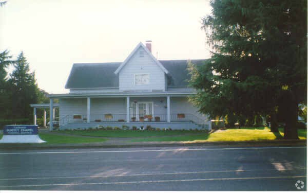

Property Detail
260 82Nd Dr
Portland-Vancouver-Hillsboro, OR-WA
124 CITY OF GLADSTONE LTS 1 & 16 BLK 80 PT LTS 6&8 LT 7 BLK 99&VAC ST
00532971
Clackamas
Commercialbuilding
Oregon
C3
7
B and X Area of moderate flood hazard, usually the area between the limits of the 100-year and 500-year floods.
0.72 AC
2025
Clackamas/Milwaukie
2025
Portland
022000
NEARBY LISTINGS FOR SALE OR LEASE
DEMOGRAPHICS near 260 82Nd Dr
1 mile
3 mile
5 mile
2024 Total Population
9,826
68,279
201,279
2029 Population
9,877
68,329
201,637
Pop Growth 2024-2029
+ 0.52%
+ 0.07%
+ 0.18%
Average Age
42
43
42
2024 Total Households
3,741
26,492
77,622
HH Growth 2024-2029
+ 0.45%
+ 0.01%
+ 0.14%
Median Household Inc
$97,085
$96,709
$96,971
Avg Household Size
2.50
2.50
2.50
2024 Avg HH Vehicles
2.00
2.00
2.00
Median Home Value
$513,971
$583,098
$623,095
Median Year Built
1974
1976
1982
Nearby Places
Map Layers
Map Styles
 Street
 Aerial
Transit
 Traffic
 Biking
Places
Listings with unknown addresses are not visible on the map
- Restaurants
- Banks
- Shops
- Fitness
- Groceries
PUBLIC TRANSPORTATION
COMMUTER RAIL
Drive
Walk
Distance
5 min
2.2 mi
AIRPORT
Portland International
Drive
Walk
Distance
Portland International
26 min
16.8 mi
Freight Ports
Port of Portland
Drive
Walk
Distance
Port of Portland
29 min
15.7 mi
Nearby Properties
Address
Land Use
TOTAL SIZE
Lot Size
Zoning
Address
Land Use
TOTAL SIZE
Lot Size
Zoning
15.26 AC
GI
Address
Land Use
TOTAL SIZE
Lot Size
Zoning
40.94 AC
IPU
Address
Land Use
TOTAL SIZE
Lot Size
Zoning
9,233 SF
8.27 AC
MUE
Address
Land Use
TOTAL SIZE
Lot Size
Zoning
4,654 SF
73.99 AC
LI
Address
Land Use
TOTAL SIZE
Lot Size
Zoning
45 AC
GI
Address
Land Use
TOTAL SIZE
Lot Size
Zoning
12.16 AC
C3
Address
Land Use
TOTAL SIZE
Lot Size
Zoning
14.06 AC
C3
Address
Land Use
TOTAL SIZE
Lot Size
Zoning
6 AC
GI
Address
Land Use
TOTAL SIZE
Lot Size
Zoning
12 AC
LI
Address
Land Use
TOTAL SIZE
Lot Size
Zoning
7.25 AC
LI
Address
Land Use
TOTAL SIZE
Lot Size
Zoning
17.04 AC
GI
Address
Land Use
TOTAL SIZE
Lot Size
Zoning
6.68 AC
C3
Address
Land Use
TOTAL SIZE
Lot Size
Zoning
2,510 SF
16.02 AC
GI
Address
Land Use
TOTAL SIZE
Lot Size
Zoning
3.11 AC
GC
Address
Land Use
TOTAL SIZE
Lot Size
Zoning
2,482 SF
5.14 AC
MR
Address
Land Use
TOTAL SIZE
Lot Size
Zoning
11 AC
MUD
Address
Land Use
TOTAL SIZE
Lot Size
Zoning
16.49 AC
MUD
Address
Land Use
TOTAL SIZE
Lot Size
Zoning
Address
Land Use
TOTAL SIZE
Lot Size
Zoning
70.97 AC
OP
Address
Land Use
TOTAL SIZE
Lot Size
Zoning
Address
Land Use
TOTAL SIZE
Lot Size
Zoning
3.18 AC
C3
Address
Land Use
TOTAL SIZE
Lot Size
Zoning
1,386 SF
12.64 AC
GI
Address
Land Use
TOTAL SIZE
Lot Size
Zoning
8.27 AC
MR
Address
Land Use
TOTAL SIZE
Lot Size
Zoning
6 AC
OP
Address
Land Use
TOTAL SIZE
Lot Size
Zoning
4 AC
GI
Address
Land Use
TOTAL SIZE
Lot Size
Zoning
2,031 SF
3.91 AC
R10
Address
Land Use
TOTAL SIZE
Lot Size
Zoning
9.90 AC
LI
Address
Land Use
TOTAL SIZE
Lot Size
Zoning
Address
Land Use
TOTAL SIZE
Lot Size
Zoning
8 AC
GI
The World's #1 Commercial Real Estate Marketplace
Connect with us
© 2026 CoStar Group
The information above has been obtained from sources believed reliable. While we do not doubt its accuracy we have not verified it and make no guarantee, warranty or representation about it. It is your responsibility to independently confirm its accuracy and completeness. Any projections, opinions, assumptions, or estimates used are for example only and do not represent the current or future performance of the property. The value of this transaction to you depends on tax and other factors which should be evaluated by your tax, financial, and legal advisors. You and your advisors should conduct a careful, independent investigation of the property to determine to your satisfaction the suitability of the property for your needs.