Property Record
260 Burns Rd, Elyria, OH 44035


Property Detail
260 Burns Rd
Cleveland-Elyria, OH
FROM -004
06-23-029-000-027
Lorain
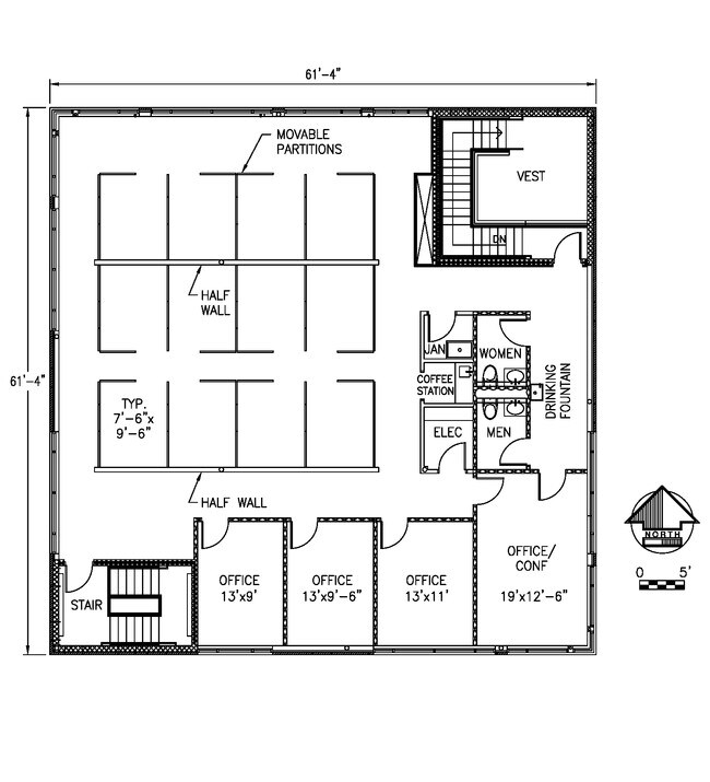
Officebuilding
Ohio
B and X Area of moderate flood hazard, usually the area between the limits of the 100-year and 500-year floods.
29
2024
4 AC
2024
Lorain County
070102
Cleveland
22,402 SF
NEARBY LISTINGS FOR SALE OR LEASE
DEMOGRAPHICS near 260 Burns Rd
1 mile
3 mile
5 mile
2025 Total Population
6,099
44,962
131,925
2030 Population
6,172
46,036
134,872
Pop Growth 2025-2030
+ 1.20%
+ 2.39%
+ 2.23%
Average Age
43
42
41
2025 Total Households
2,554
18,653
53,276
HH Growth 2025-2030
+ 1.29%
+ 2.48%
+ 2.27%
Median Household Inc
$76,571
$77,064
$73,076
Avg Household Size
2.40
2.40
2.40
2025 Avg HH Vehicles
2.00
2.00
2.00
Median Home Value
$208,657
$214,657
$209,660
Median Year Built
1968
1970
1972
Nearby Places
Map Layers
Map Styles
 Street
 Aerial
Transit
 Traffic
 Biking
Places
Listings with unknown addresses are not visible on the map
- Restaurants
- Banks
- Shops
- Fitness
- Groceries
PUBLIC TRANSPORTATION
COMMUTER RAIL
Drive
Walk
Distance
9 min
3.9 mi
AIRPORT
Cleveland-Hopkins International
Drive
Walk
Distance
Cleveland-Hopkins International
32 min
20.9 mi
SALE & LEASE HISTORY
LISTING DATE
SALE/LEASE

Mar 02, 2022
For Sale
Jun 29, 2020
For Lease
Aug 14, 2017
For Lease
Apr 11, 2022
For Lease
Nearby Properties
Address
Land Use
TOTAL SIZE
Lot Size
Zoning
Address
Land Use
TOTAL SIZE
Lot Size
Zoning
908,481 SF
48.80 AC
Address
Land Use
TOTAL SIZE
Lot Size
Zoning
85,502 SF
15.47 AC
Address
Land Use
TOTAL SIZE
Lot Size
Zoning
128,869 SF
30.06 AC
Address
Land Use
TOTAL SIZE
Lot Size
Zoning
163,892 SF
46.81 AC
Address
Land Use
TOTAL SIZE
Lot Size
Zoning
50,761 SF
46.25 AC
Address
Land Use
TOTAL SIZE
Lot Size
Zoning
129,277 SF
17.35 AC
Address
Land Use
TOTAL SIZE
Lot Size
Zoning
66,474 SF
43.04 AC
Address
Land Use
TOTAL SIZE
Lot Size
Zoning
41,842 SF
10.38 AC
Address
Land Use
TOTAL SIZE
Lot Size
Zoning
346,114 SF
37.97 AC
Address
Land Use
TOTAL SIZE
Lot Size
Zoning
46,764 SF
2.98 AC
Address
Land Use
TOTAL SIZE
Lot Size
Zoning
115,734 SF
29.86 AC
Address
Land Use
TOTAL SIZE
Lot Size
Zoning
79,556 SF
17.55 AC
Address
Land Use
TOTAL SIZE
Lot Size
Zoning
44,646 SF
6.46 AC
Address
Land Use
TOTAL SIZE
Lot Size
Zoning
126,448 SF
22.54 AC
Address
Land Use
TOTAL SIZE
Lot Size
Zoning
159,052 SF
36.16 AC
Address
Land Use
TOTAL SIZE
Lot Size
Zoning
169,280 SF
15.56 AC
Address
Land Use
TOTAL SIZE
Lot Size
Zoning
90,319 SF
10.88 AC
Address
Land Use
TOTAL SIZE
Lot Size
Zoning
61,278 SF
8.25 AC
Address
Land Use
TOTAL SIZE
Lot Size
Zoning
60,452 SF
0.61 AC
Address
Land Use
TOTAL SIZE
Lot Size
Zoning
18,827 SF
1.68 AC
Address
Land Use
TOTAL SIZE
Lot Size
Zoning
971,475 SF
54.21 AC
Address
Land Use
TOTAL SIZE
Lot Size
Zoning
100,025 SF
9.06 AC
Address
Land Use
TOTAL SIZE
Lot Size
Zoning
29,864 SF
3.96 AC
Address
Land Use
TOTAL SIZE
Lot Size
Zoning
33,624 SF
13.17 AC
Address
Land Use
TOTAL SIZE
Lot Size
Zoning
106,325 SF
2.25 AC
Address
Land Use
TOTAL SIZE
Lot Size
Zoning
286,466 SF
19.67 AC
Address
Land Use
TOTAL SIZE
Lot Size
Zoning
97.64 AC
Address
Land Use
TOTAL SIZE
Lot Size
Zoning
28,595 SF
10.61 AC
Address
Land Use
TOTAL SIZE
Lot Size
Zoning
104,280 SF
9.18 AC
Address
Land Use
TOTAL SIZE
Lot Size
Zoning
77,970 SF
38.55 AC
The World's #1 Commercial Real Estate Marketplace
Connect with us
© 2026 CoStar Group
The information above has been obtained from sources believed reliable. While we do not doubt its accuracy we have not verified it and make no guarantee, warranty or representation about it. It is your responsibility to independently confirm its accuracy and completeness. Any projections, opinions, assumptions, or estimates used are for example only and do not represent the current or future performance of the property. The value of this transaction to you depends on tax and other factors which should be evaluated by your tax, financial, and legal advisors. You and your advisors should conduct a careful, independent investigation of the property to determine to your satisfaction the suitability of the property for your needs.