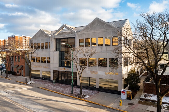
Property Record
260 E Brown St, Birmingham, MI 48009


Current Lease Availabilities
Property Detail
260 E Brown St
19-36-204-025
T2N, R10E, SEC 36 BROWN'S ADD E 49.90 FT OF LOT 10 & W 1/2 OF LOT 11, ALSO W 1/2 OF LOT 16 & ALL OF LOT 17 OF 'BROWN'S ADD NO 1' 11-12-85 FR019,020,022,023 & 024
Officebuilding
Oakland
BI
Michigan
B and X Area of moderate flood hazard, usually the area between the limits of the 100-year and 500-year floods.
10
2024
0.57 AC
2025
Birmingham
153200
Detroit
53,566 SF
Detroit-Warren-Dearborn, MI
NEARBY LISTINGS FOR SALE OR LEASE
DEMOGRAPHICS near 260 E Brown St
1 mile
3 mile
5 mile
2025 Total Population
16,581
91,192
234,380
2030 Population
17,029
93,039
238,863
Pop Growth 2025-2030
+ 2.70%
+ 2.03%
+ 1.91%
Average Age
43
42
42
2025 Total Households
7,485
39,813
99,756
HH Growth 2025-2030
+ 2.85%
+ 2.13%
+ 2.03%
Median Household Inc
$151,665
$113,101
$107,660
Avg Household Size
2.20
2.30
2.30
2025 Avg HH Vehicles
2.00
2.00
2.00
Median Home Value
$729,562
$436,212
$381,320
Median Year Built
1959
1963
1963
Nearby Places
Map Layers
Map Styles
 Street
 Aerial
Layers
 Traffic
 Biking
Places
Listings with unknown addresses are not visible on the map
- Restaurants
- Banks
- Shops
- Fitness
- Groceries
PUBLIC TRANSPORTATION
AIRPORT
Windsor International
Drive
Walk
Distance
Windsor International
51 min
28.4 mi
Detroit Metro Wayne County
Drive
Walk
Distance
Detroit Metro Wayne County
49 min
30.4 mi
Nearby Properties
Address
Land Use
TOTAL SIZE
Lot Size
Zoning
Address
Land Use
TOTAL SIZE
Lot Size
Zoning
399,735 SF
19.71 AC
B2
Address
Land Use
TOTAL SIZE
Lot Size
Zoning
224,766 SF
19.92 AC
B2
Address
Land Use
TOTAL SIZE
Lot Size
Zoning
512,471 SF
21 AC
Address
Land Use
TOTAL SIZE
Lot Size
Zoning
512,475 SF
20.02 AC
Address
Land Use
TOTAL SIZE
Lot Size
Zoning
15.32 AC
GEN BUS
Address
Land Use
TOTAL SIZE
Lot Size
Zoning
111,030 SF
0.97 AC
BI
Address
Land Use
TOTAL SIZE
Lot Size
Zoning
149,395 SF
1.02 AC
BI
Address
Land Use
TOTAL SIZE
Lot Size
Zoning
208,296 SF
8.16 AC
OSC
Address
Land Use
TOTAL SIZE
Lot Size
Zoning
143,160 SF
0.84 AC
BI
Address
Land Use
TOTAL SIZE
Lot Size
Zoning
236,140 SF
1.67 AC
BI
Address
Land Use
TOTAL SIZE
Lot Size
Zoning
99,661 SF
0.62 AC
Address
Land Use
TOTAL SIZE
Lot Size
Zoning
427,945 SF
18.26 AC
OSC
Address
Land Use
TOTAL SIZE
Lot Size
Zoning
160,796 SF
1.84 AC
Address
Land Use
TOTAL SIZE
Lot Size
Zoning
365,104 SF
2.03 AC
Address
Land Use
TOTAL SIZE
Lot Size
Zoning
301,728 SF
2.83 AC
B2
Address
Land Use
TOTAL SIZE
Lot Size
Zoning
119,732 SF
3.77 AC
Address
Land Use
TOTAL SIZE
Lot Size
Zoning
83,244 SF
0.38 AC
Address
Land Use
TOTAL SIZE
Lot Size
Zoning
72,457 SF
5.60 AC
OFFICE SVC
Address
Land Use
TOTAL SIZE
Lot Size
Zoning
206,913 SF
16.99 AC
O1
Address
Land Use
TOTAL SIZE
Lot Size
Zoning
154,370 SF
8.80 AC
BI
Address
Land Use
TOTAL SIZE
Lot Size
Zoning
4.21 AC
Address
Land Use
TOTAL SIZE
Lot Size
Zoning
84,711 SF
5.05 AC
BI
Address
Land Use
TOTAL SIZE
Lot Size
Zoning
301,276 SF
13.58 AC
AI
Address
Land Use
TOTAL SIZE
Lot Size
Zoning
279,360 SF
14.34 AC
RM1
Address
Land Use
TOTAL SIZE
Lot Size
Zoning
76,260 SF
8.09 AC
Address
Land Use
TOTAL SIZE
Lot Size
Zoning
8,914 SF
5 AC
Address
Land Use
TOTAL SIZE
Lot Size
Zoning
212 SF
16.59 AC
RM
Address
Land Use
TOTAL SIZE
Lot Size
Zoning
225,890 SF
10.10 AC
OM
Address
Land Use
TOTAL SIZE
Lot Size
Zoning
80,334 SF
0.57 AC
BI
Address
Land Use
TOTAL SIZE
Lot Size
Zoning
79,935 SF
1.02 AC
BI
The World's #1 Commercial Real Estate Marketplace
Connect with us
© 2026 CoStar Group
The information above has been obtained from sources believed reliable. While we do not doubt its accuracy we have not verified it and make no guarantee, warranty or representation about it. It is your responsibility to independently confirm its accuracy and completeness. Any projections, opinions, assumptions, or estimates used are for example only and do not represent the current or future performance of the property. The value of this transaction to you depends on tax and other factors which should be evaluated by your tax, financial, and legal advisors. You and your advisors should conduct a careful, independent investigation of the property to determine to your satisfaction the suitability of the property for your needs.