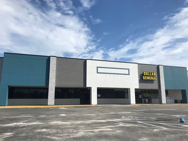
Property Record
260 E State Road 434, Winter Springs, FL 32708


NEARBY LISTINGS FOR SALE OR LEASE
Property Detail
260 E State Road 434
Orlando-Kissimmee-Sanford, FL
D R Mitchells Survey Of The Levy Grant
26-20-30-5AR-0D00-0120
PT OF LOTS 12 & 52 BLK D DESC AS BEG 317 FT N & 575.71 FT E OF SW COR OF SE 1/4 RUN N 83 DEG 2 MIN 40 SEC E 351.54 N 72 DEG 23 SEC E 115.86 FT N 27 DEG 51 MIN 19 SEC W 191.62 FT N 64 DEG 48 MIN 1 SEC E 66.50 FT N 8 DEG 26 MIN 48 SEC W 134.53 FT N 85
Storebuilding
Seminole
X
Florida
12117C0160F
12,52
2025
8.31 AC
2025
Longwood
021401
Orlando
7,800 SF
DEMOGRAPHICS near 260 E State Road 434
1 Mile
3 Mile
5 Mile
2024 Total Population
10,185
62,435
182,932
2029 Population
10,543
64,944
189,961
Pop Growth 2024-2029
+ 3.51%
+ 4.02%
+ 3.84%
Average Age
41
41
42
2024 Total Households
4,080
24,345
71,663
HH Growth 2024-2029
+ 3.70%
+ 4.13%
+ 3.97%
Median Household Inc
$56,976
$67,440
$69,278
Avg Household Size
2.50
2.50
2.50
2024 Avg HH Vehicles
2.00
2.00
2.00
Median Home Value
$226,379
$289,970
$301,881
Median Year Built
1980
1984
1984
Nearby Places
Map Layers
Map Styles
 Street
 Aerial
- Restaurants
- Banks
- Shops
- Fitness
- Groceries
PUBLIC TRANSPORTATION
COMMUTER RAIL
Longwood (SunRail - Florida Department of Transportation)
DRIVE
WALK
Distance
Longwood (SunRail - Florida Department of Transportation)
6 min
3.0 mi
Altamonte Springs (SunRail - Florida Department of Transportation)
DRIVE
WALK
Distance
Altamonte Springs (SunRail - Florida Department of Transportation)
10 min
5.3 mi
AIRPORT
Orlando Sanford International
DRIVE
WALK
Distance
Orlando Sanford International
17 min
9.1 mi
Orlando International
DRIVE
WALK
Distance
Orlando International
37 min
21.1 mi
Freight Ports
Port Canaveral
DRIVE
WALK
Distance
Port Canaveral
76 min
62.6 mi
SALE & LEASE HISTORY
LISTING DATE
SALE/LEASE

Oct 21, 2016
For Lease
Nov 18, 2016
For Lease
Nearby Properties
Address
Land Use
TOTAL SIZE
Lot Size
Zoning
Address
Land Use
TOTAL SIZE
Lot Size
Zoning
21.25 AC
GC
Address
Land Use
TOTAL SIZE
Lot Size
Zoning
629,182 SF
1.81 AC
R1A
Address
Land Use
TOTAL SIZE
Lot Size
Zoning
540 SF
7.72 AC
GC
Address
Land Use
TOTAL SIZE
Lot Size
Zoning
350,767 SF
11.12 AC
PUD
Address
Land Use
TOTAL SIZE
Lot Size
Zoning
351,501 SF
4.45 AC
TC
Address
Land Use
TOTAL SIZE
Lot Size
Zoning
456 SF
9.56 AC
Address
Land Use
TOTAL SIZE
Lot Size
Zoning
97,888 SF
3.72 AC
IND
Address
Land Use
TOTAL SIZE
Lot Size
Zoning
387,705 SF
61.24 AC
TC
Address
Land Use
TOTAL SIZE
Lot Size
Zoning
10,757 SF
70.59 AC
C2
Address
Land Use
TOTAL SIZE
Lot Size
Zoning
390,293 SF
47.33 AC
PI
Address
Land Use
TOTAL SIZE
Lot Size
Zoning
365,430 SF
2.70 AC
RMF13
Address
Land Use
TOTAL SIZE
Lot Size
Zoning
1,518 SF
12.08 AC
PUD
Address
Land Use
TOTAL SIZE
Lot Size
Zoning
141,356 SF
5.07 AC
Address
Land Use
TOTAL SIZE
Lot Size
Zoning
25,488 SF
2.54 AC
Address
Land Use
TOTAL SIZE
Lot Size
Zoning
1,696 SF
0.16 AC
A1
Address
Land Use
TOTAL SIZE
Lot Size
Zoning
30,627 SF
1.89 AC
Address
Land Use
TOTAL SIZE
Lot Size
Zoning
55,542 SF
9.72 AC
TC
Address
Land Use
TOTAL SIZE
Lot Size
Zoning
25,488 SF
2.19 AC
Address
Land Use
TOTAL SIZE
Lot Size
Zoning
178,855 SF
34.08 AC
PUD
Address
Land Use
TOTAL SIZE
Lot Size
Zoning
140,456 SF
8.45 AC
R1
Address
Land Use
TOTAL SIZE
Lot Size
Zoning
183,225 SF
31.62 AC
PS
Address
Land Use
TOTAL SIZE
Lot Size
Zoning
113,556 SF
74.69 AC
A1
Address
Land Use
TOTAL SIZE
Lot Size
Zoning
109,610 SF
6.52 AC
Address
Land Use
TOTAL SIZE
Lot Size
Zoning
155,639 SF
18.55 AC
A1
Address
Land Use
TOTAL SIZE
Lot Size
Zoning
111,921 SF
5.22 AC
M1
Address
Land Use
TOTAL SIZE
Lot Size
Zoning
98,202 SF
9.03 AC
CG
Address
Land Use
TOTAL SIZE
Lot Size
Zoning
35.82 AC
Address
Land Use
TOTAL SIZE
Lot Size
Zoning
96,858 SF
4.88 AC
M1
Address
Land Use
TOTAL SIZE
Lot Size
Zoning
91,706 SF
4.38 AC
GC
Address
Land Use
TOTAL SIZE
Lot Size
Zoning
110,103 SF
23.89 AC
PUD
The World's #1 Commercial Real Estate Marketplace
Connect with us
© 2026 CoStar Group
The information above has been obtained from sources believed reliable. While we do not doubt its accuracy we have not verified it and make no guarantee, warranty or representation about it. It is your responsibility to independently confirm its accuracy and completeness. Any projections, opinions, assumptions, or estimates used are for example only and do not represent the current or future performance of the property. The value of this transaction to you depends on tax and other factors which should be evaluated by your tax, financial, and legal advisors. You and your advisors should conduct a careful, independent investigation of the property to determine to your satisfaction the suitability of the property for your needs.