Property Record
260 Highway 35 N, Batesville, MS 38606

NEARBY LISTINGS FOR SALE OR LEASE
-
-
View all Batesville listings for sale on LoopNet.com
Property Detail
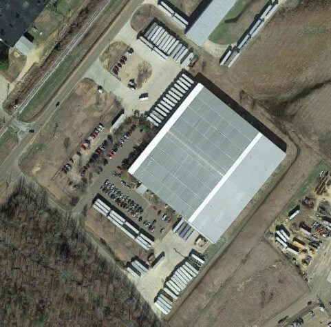
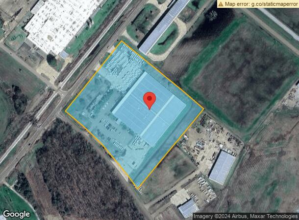
260 Highway 35 N
Industrialgeneral
10.3AC PT E1/2 NE1/4 E OF HWY 35 & N OF RD
X
Panola
28107C0308D
Mississippi
2024
10.30 AC
2024
Other Market Areas
950601
3182-0005000-10000202
88,114 SF
DEMOGRAPHICS near 260 Highway 35 N
1 Mile
3 Mile
5 Mile
2024 Total Population
604
6,997
10,672
2029 Population
583
6,817
10,447
Pop Growth 2024-2029
(3.48%)
(2.57%)
(2.11%)
Average Age
39
38
38
2024 Total Households
237
2,610
3,965
HH Growth 2024-2029
(3.38%)
(2.57%)
(2.09%)
Median Household Inc
$60,234
$34,925
$46,040
Avg Household Size
2.50
2.60
2.60
2024 Avg HH Vehicles
2.00
2.00
2.00
Median Home Value
$150,000
$143,846
$134,873
Median Year Built
1983
1983
1984
Nearby Places
Map Layers
Map Styles
 Street
 Aerial
- Restaurants
- Banks
- Shops
- Fitness
- Groceries
SALE & LEASE HISTORY
LISTING DATE
SALE/LEASE

Feb 13, 2019
For Sale
Nearby Properties
Address
Land Use
TOTAL SIZE
Lot Size
Zoning
Address
Land Use
TOTAL SIZE
Lot Size
Zoning
138,838 SF
14.30 AC
Address
Land Use
TOTAL SIZE
Lot Size
Zoning
10,000 SF
90.70 AC
Address
Land Use
TOTAL SIZE
Lot Size
Zoning
119,834 SF
23.70 AC
Address
Land Use
TOTAL SIZE
Lot Size
Zoning
9,911 SF
9.80 AC
Address
Land Use
TOTAL SIZE
Lot Size
Zoning
5,802 SF
11.50 AC
Address
Land Use
TOTAL SIZE
Lot Size
Zoning
4,120 SF
39 AC
Address
Land Use
TOTAL SIZE
Lot Size
Zoning
108,001 SF
13.10 AC
Address
Land Use
TOTAL SIZE
Lot Size
Zoning
Address
Land Use
TOTAL SIZE
Lot Size
Zoning
97,155 SF
14.20 AC
Address
Land Use
TOTAL SIZE
Lot Size
Zoning
5,901 SF
7 AC
Address
Land Use
TOTAL SIZE
Lot Size
Zoning
7,492 SF
45.50 AC
Address
Land Use
TOTAL SIZE
Lot Size
Zoning
2.20 AC
Address
Land Use
TOTAL SIZE
Lot Size
Zoning
10,000 SF
26.50 AC
Address
Land Use
TOTAL SIZE
Lot Size
Zoning
49,248 SF
2.40 AC
Address
Land Use
TOTAL SIZE
Lot Size
Zoning
10,530 SF
12 AC
Address
Land Use
TOTAL SIZE
Lot Size
Zoning
41,413 SF
2.80 AC
Address
Land Use
TOTAL SIZE
Lot Size
Zoning
20,172 SF
2.10 AC
Address
Land Use
TOTAL SIZE
Lot Size
Zoning
50,486 SF
3 AC
Address
Land Use
TOTAL SIZE
Lot Size
Zoning
29,333 SF
1.80 AC
Address
Land Use
TOTAL SIZE
Lot Size
Zoning
42,389 SF
12.70 AC
Address
Land Use
TOTAL SIZE
Lot Size
Zoning
5,725 SF
0.57 AC
Address
Land Use
TOTAL SIZE
Lot Size
Zoning
15,086 SF
1.80 AC
The World's #1 Commercial Real Estate Marketplace
Connect with us
© 2025 CoStar Group
The information above has been obtained from sources believed reliable. While we do not doubt its accuracy we have not verified it and make no guarantee, warranty or representation about it. It is your responsibility to independently confirm its accuracy and completeness. Any projections, opinions, assumptions, or estimates used are for example only and do not represent the current or future performance of the property. The value of this transaction to you depends on tax and other factors which should be evaluated by your tax, financial, and legal advisors. You and your advisors should conduct a careful, independent investigation of the property to determine to your satisfaction the suitability of the property for your needs.