Property Record
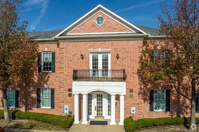
260 N Denton Tap Rd, Coppell, TX 75019


NEARBY LISTINGS FOR SALE OR LEASE
Property Detail
260 N Denton Tap Rd
Dallas-Fort Worth-Arlington, TX
Princeton Park
18006100010010000
PRINCETON PARK BLK 1 LT 1 ACS 1.6562 INT201500217139 DD08132015 CO-DC 0061000100100 1CO00610001
Officebuilding
Dallas
X
Texas
48113C0155K
1
2024
1.66 AC
2025
DFW Freeport/Coppell
014135
Dallas/Ft Worth
24,360 SF
DEMOGRAPHICS near 260 N Denton Tap Rd
1 Mile
3 Mile
5 Mile
2024 Total Population
11,677
91,764
210,545
2029 Population
11,464
99,804
232,921
Pop Growth 2024-2029
(1.82%)
+ 8.76%
+ 10.63%
Average Age
38
37
37
2024 Total Households
3,821
37,199
81,392
HH Growth 2024-2029
(1.75%)
+ 9.68%
+ 10.74%
Median Household Inc
$146,760
$92,729
$93,401
Avg Household Size
3.00
2.40
2.50
2024 Avg HH Vehicles
2.00
2.00
2.00
Median Home Value
$453,654
$403,945
$373,911
Median Year Built
1993
1996
1994
Nearby Places
Map Layers
Map Styles
 Street
 Aerial
- Restaurants
- Banks
- Shops
- Fitness
- Groceries
PUBLIC TRANSPORTATION
AIRPORT
Dallas-Fort Worth International
DRIVE
WALK
Distance
Dallas-Fort Worth International
14 min
9.4 mi
Dallas Love Field
DRIVE
WALK
Distance
Dallas Love Field
29 min
17.9 mi
SALE & LEASE HISTORY
LISTING DATE
SALE/LEASE

Nov 04, 2016
For Lease
Feb 20, 2018
For Lease
Nearby Properties
Address
Land Use
TOTAL SIZE
Lot Size
Zoning
Address
Land Use
TOTAL SIZE
Lot Size
Zoning
2,545,604 SF
123.01 AC
Z402
Address
Land Use
TOTAL SIZE
Lot Size
Zoning
1,325,709 SF
124.50 AC
Address
Land Use
TOTAL SIZE
Lot Size
Zoning
444,824 SF
19.08 AC
Address
Land Use
TOTAL SIZE
Lot Size
Zoning
527,463 SF
42.25 AC
Address
Land Use
TOTAL SIZE
Lot Size
Zoning
768,494 SF
10.42 AC
Address
Land Use
TOTAL SIZE
Lot Size
Zoning
1,581,742 SF
53.48 AC
Z123
Address
Land Use
TOTAL SIZE
Lot Size
Zoning
190,223 SF
0.03 AC
Z392
Address
Land Use
TOTAL SIZE
Lot Size
Zoning
481,511 SF
34.76 AC
Z172
Address
Land Use
TOTAL SIZE
Lot Size
Zoning
808,352 SF
7.87 AC
Address
Land Use
TOTAL SIZE
Lot Size
Zoning
1,065,080 SF
49.57 AC
Z123
Address
Land Use
TOTAL SIZE
Lot Size
Zoning
835,344 SF
143.50 AC
Address
Land Use
TOTAL SIZE
Lot Size
Zoning
452,167 SF
5.80 AC
Address
Land Use
TOTAL SIZE
Lot Size
Zoning
1,076,400 SF
48.83 AC
Z01
Address
Land Use
TOTAL SIZE
Lot Size
Zoning
457,738 SF
28.49 AC
Address
Land Use
TOTAL SIZE
Lot Size
Zoning
313,369 SF
55.25 AC
Address
Land Use
TOTAL SIZE
Lot Size
Zoning
242,707 SF
27.63 AC
Z343
Address
Land Use
TOTAL SIZE
Lot Size
Zoning
352,209 SF
17.54 AC
Z172
Address
Land Use
TOTAL SIZE
Lot Size
Zoning
950,000 SF
45.32 AC
Z123
Address
Land Use
TOTAL SIZE
Lot Size
Zoning
394,048 SF
16.36 AC
Address
Land Use
TOTAL SIZE
Lot Size
Zoning
544,650 SF
26.03 AC
Z177
Address
Land Use
TOTAL SIZE
Lot Size
Zoning
379,940 SF
63.48 AC
Z31
Address
Land Use
TOTAL SIZE
Lot Size
Zoning
382,330 SF
21.43 AC
3B
Address
Land Use
TOTAL SIZE
Lot Size
Zoning
284,952 SF
26.18 AC
Address
Land Use
TOTAL SIZE
Lot Size
Zoning
184,186 SF
34.74 AC
Z31
Address
Land Use
TOTAL SIZE
Lot Size
Zoning
581,211 SF
9 AC
Z239
Address
Land Use
TOTAL SIZE
Lot Size
Zoning
329,666 SF
19.76 AC
Address
Land Use
TOTAL SIZE
Lot Size
Zoning
385,247 SF
22.59 AC
3B
Address
Land Use
TOTAL SIZE
Lot Size
Zoning
344,868 SF
19.44 AC
Address
Land Use
TOTAL SIZE
Lot Size
Zoning
514,192 SF
21.56 AC
3B
Address
Land Use
TOTAL SIZE
Lot Size
Zoning
412,389 SF
16.69 AC
3B
The World's #1 Commercial Real Estate Marketplace
Connect with us
© 2025 CoStar Group
The information above has been obtained from sources believed reliable. While we do not doubt its accuracy we have not verified it and make no guarantee, warranty or representation about it. It is your responsibility to independently confirm its accuracy and completeness. Any projections, opinions, assumptions, or estimates used are for example only and do not represent the current or future performance of the property. The value of this transaction to you depends on tax and other factors which should be evaluated by your tax, financial, and legal advisors. You and your advisors should conduct a careful, independent investigation of the property to determine to your satisfaction the suitability of the property for your needs.