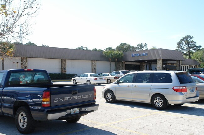
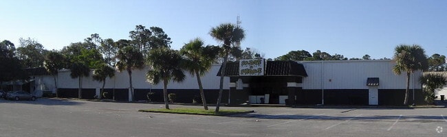
Property Record
260 N Us Highway 1, Ormond Beach, FL 32174

Property Detail
260 N Us Highway 1
4241-46-00-0010
UNIT 1 ROSEWOOD COMMERCIAL CONDO OR 6304 PG 3221 PER OR 7176 PG 2507
Recreationalentertainmentgeneral
Volusia
AE The base floodplain where base flood elevations are provided. AE Zones are now used on new format FIRMs instead of A1-A30 Zones.
Florida
2025
7.19 AC
2026
Ormond Beach
080600
Deltona/Daytona Beach
40,311 SF
Deltona-Daytona Beach-Ormond Beach, FL
NEARBY LISTINGS FOR SALE OR LEASE
DEMOGRAPHICS near 260 N Us Highway 1
1 mile
3 mile
5 mile
2025 Total Population
5,798
49,595
100,235
2030 Population
6,189
53,540
108,515
Pop Growth 2025-2030
+ 6.74%
+ 7.95%
+ 8.26%
Average Age
46
48
47
2025 Total Households
2,646
22,807
45,382
HH Growth 2025-2030
+ 6.76%
+ 8.05%
+ 8.41%
Median Household Inc
$44,596
$56,881
$59,487
Avg Household Size
2.10
2.10
2.10
2025 Avg HH Vehicles
2.00
2.00
2.00
Median Home Value
$381,249
$344,991
$340,558
Median Year Built
1976
1978
1979
Nearby Places
Map Layers
Map Styles
 Street
 Aerial
Layers
 Traffic
 Biking
Places
Listings with unknown addresses are not visible on the map
- Restaurants
- Banks
- Shops
- Fitness
- Groceries
PUBLIC TRANSPORTATION
AIRPORT
Daytona Beach International
Drive
Walk
Distance
Daytona Beach International
23 min
11.2 mi
Nearby Properties
Address
Land Use
TOTAL SIZE
Lot Size
Zoning
Address
Land Use
TOTAL SIZE
Lot Size
Zoning
12,394 SF
139.59 AC
Address
Land Use
TOTAL SIZE
Lot Size
Zoning
300,760 SF
20.75 AC
Address
Land Use
TOTAL SIZE
Lot Size
Zoning
16.50 AC
Address
Land Use
TOTAL SIZE
Lot Size
Zoning
Address
Land Use
TOTAL SIZE
Lot Size
Zoning
Address
Land Use
TOTAL SIZE
Lot Size
Zoning
168,456 SF
15.74 AC
Address
Land Use
TOTAL SIZE
Lot Size
Zoning
4,182 SF
0.16 AC
MH1
Address
Land Use
TOTAL SIZE
Lot Size
Zoning
144,576 SF
11.19 AC
13R6
Address
Land Use
TOTAL SIZE
Lot Size
Zoning
149,872 SF
20 AC
09R6
Address
Land Use
TOTAL SIZE
Lot Size
Zoning
162,450 SF
1.42 AC
13B9
Address
Land Use
TOTAL SIZE
Lot Size
Zoning
179,868 SF
0.33 AC
Address
Land Use
TOTAL SIZE
Lot Size
Zoning
61,570 SF
23.04 AC
Address
Land Use
TOTAL SIZE
Lot Size
Zoning
148,966 SF
5.54 AC
13B10
Address
Land Use
TOTAL SIZE
Lot Size
Zoning
Address
Land Use
TOTAL SIZE
Lot Size
Zoning
135,886 SF
1.18 AC
Address
Land Use
TOTAL SIZE
Lot Size
Zoning
119,331 SF
9.09 AC
Address
Land Use
TOTAL SIZE
Lot Size
Zoning
96,309 SF
29.04 AC
Address
Land Use
TOTAL SIZE
Lot Size
Zoning
87,633 SF
568.97 AC
RR
Address
Land Use
TOTAL SIZE
Lot Size
Zoning
173,757 SF
11.64 AC
Address
Land Use
TOTAL SIZE
Lot Size
Zoning
125,088 SF
10.66 AC
B3
Address
Land Use
TOTAL SIZE
Lot Size
Zoning
94,926 SF
3.85 AC
Address
Land Use
TOTAL SIZE
Lot Size
Zoning
68,131 SF
5.53 AC
Address
Land Use
TOTAL SIZE
Lot Size
Zoning
102,345 SF
2.74 AC
Address
Land Use
TOTAL SIZE
Lot Size
Zoning
117,116 SF
18 AC
Address
Land Use
TOTAL SIZE
Lot Size
Zoning
57,875 SF
1.95 AC
13B6
Address
Land Use
TOTAL SIZE
Lot Size
Zoning
Address
Land Use
TOTAL SIZE
Lot Size
Zoning
98,646 SF
6.88 AC
13B4
Address
Land Use
TOTAL SIZE
Lot Size
Zoning
Address
Land Use
TOTAL SIZE
Lot Size
Zoning
85,950 SF
8.24 AC
Address
Land Use
TOTAL SIZE
Lot Size
Zoning
66,896 SF
7.65 AC
B4
The World's #1 Commercial Real Estate Marketplace
Connect with us
© 2026 CoStar Group
The information above has been obtained from sources believed reliable. While we do not doubt its accuracy we have not verified it and make no guarantee, warranty or representation about it. It is your responsibility to independently confirm its accuracy and completeness. Any projections, opinions, assumptions, or estimates used are for example only and do not represent the current or future performance of the property. The value of this transaction to you depends on tax and other factors which should be evaluated by your tax, financial, and legal advisors. You and your advisors should conduct a careful, independent investigation of the property to determine to your satisfaction the suitability of the property for your needs.